- Home
- :
- All Communities
- :
- Products
- :
- Data Management
- :
- Data Management Blog
- :
- A Toolbar for Splitting Address Ranges and Managin...
A Toolbar for Splitting Address Ranges and Managing Address Ranges
- Subscribe to RSS Feed
- Mark as New
- Mark as Read
- Bookmark
- Subscribe
- Printer Friendly Page
I have developed a tool for splitting address ranges and have attached it. Below is a description of how it works.
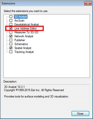
The toolbar is tied to an Editor Extension that must be enabled in order for the tools to work. It is using the Python Editor extension which can slow performance when doing edit selections, so you generally should leave the extension off and only turn it on when you need to do address range splits or manipulations. To turn the extension on or off click on the Customize menu->Extensions… submenu and when the extension dialog opens check or uncheck the item outlined in red shown below:
The tools on the toolbar only become enabled when you begin an Editor session. You need to select the polyline layer you want the tools to act on in the table of contents window (the layer name must be highlighted)

The toolbar is shown below and has five groups of tools.
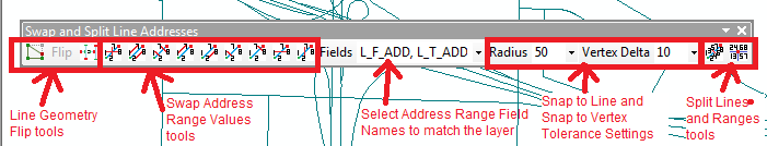
The first tools flip line geometry without affecting address range values. The first two tools are the same as the Edit Vertices tool and the Flip tool for a single selected line you are familiar with in ArcMap. The third button uses the Flip Line tool which will flip all selected lines, but it requires an Advanced license to use it.
The second set of tools swap address values between the different address range fields. The first 3 buttons swap dual address pairs. The six other buttons swap single address pairs. With these 9 buttons all swap combinations can be done either by a single button or combining two or three buttons.
The next drop down is a list of field names that match the address range fields in your polylines. The tool should detect this if your layer uses one of the listed set of field names and select the one that matches. If it does not match you field names tell me what they are and I will add you address range field names to the list. You can manually type the names in, but I prefer to make the list cover all user configurations.
The next two drop downs control the snap tolerance affecting whether or not a line will split and whether that split will occur on a vertex or just on a line edge, respectively. The units are in the native units of your layer.
The last two tools split lines and address ranges. It is critical that your line geometry and ranges are aligned together properly before you use these tools. The first button is like the ArcMap Split tool where you must select a single line from the highlighted layer and click on the map to split the geometry and address ranges proportionally. The second button is like the Planarize tool and requires that you select two or more intersecting lines from the highlighted layer that will split the geometry and proportional ranges where they intersect each other.
Let me know if this works for you or if you have any problems. There are some known limitations, particularly if you are editing SDE data.
You must be a registered user to add a comment. If you've already registered, sign in. Otherwise, register and sign in.