- Home
- :
- All Communities
- :
- User Groups
- :
- Coordinate Reference Systems
- :
- Questions
- :
- Re: Using the Raster calculator to determine slope...
- Subscribe to RSS Feed
- Mark Topic as New
- Mark Topic as Read
- Float this Topic for Current User
- Bookmark
- Subscribe
- Mute
- Printer Friendly Page
Using the Raster calculator to determine slope length
- Mark as New
- Bookmark
- Subscribe
- Mute
- Subscribe to RSS Feed
- Permalink
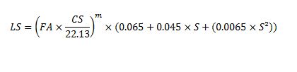
Hallo All, I am trying to use the raster calculator to calculate Slope length SL for my RUSLE model. All the necessary layers as inputs have been prepare including flow accumulation, slope in percentage. But when iinput the formula (see attached) and run the map algebra tool i receive an error message. Any ideas where i may be missing it?
- Mark as New
- Bookmark
- Subscribe
- Mute
- Subscribe to RSS Feed
- Permalink
drop the LS == that is checking for equality, your output will be named as given in the output line
use sqrt ... not sure if ^0.5 works in all places... but be safe.
why don't you split stuff and do the calculations in baby steps to ensure that each component works?
you can then delete the intermediate steps or combine them into one smokin' one-liner if the pieces work.
PS move this to Spatial Analyst it has nothing to do with coordinate reference systems
- Mark as New
- Bookmark
- Subscribe
- Mute
- Subscribe to RSS Feed
- Permalink
What is LS == supposed to mean?
Also, I suspect you're going to want to change ^ to ** (Map Algebra operators).
- Mark as New
- Bookmark
- Subscribe
- Mute
- Subscribe to RSS Feed
- Permalink
@Darren LS represent Slope length and is one important input in the RUSLE model
- Mark as New
- Bookmark
- Subscribe
- Mute
- Subscribe to RSS Feed
- Permalink
There many links on this site, albeit, 3-5 years old on LS ... search using ... usle ... as a search key, for more background and links
- Mark as New
- Bookmark
- Subscribe
- Mute
- Subscribe to RSS Feed
- Permalink
checked but found only one, and that was on model building, but thanks. Will follow your earlier suggestion to do it peace meal and see what happens.
- Mark as New
- Bookmark
- Subscribe
- Mute
- Subscribe to RSS Feed
- Permalink
Considering the output of the expression in Raster Calculator is Slope Length (LS), you need to do following two steps
1) Delete LS== from the expression. (You do not mention the LHS in the expression here in Raster Calculator)
2) Replace ^ with ** for square operation.
Think Location
- Mark as New
- Bookmark
- Subscribe
- Mute
- Subscribe to RSS Feed
- Permalink
covered way above... and sqrt would be better
- Mark as New
- Bookmark
- Subscribe
- Mute
- Subscribe to RSS Feed
- Permalink
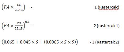
@Dan, i have done it in bits as you suggested and it worked, but i am confused with "sqrt" suggested. below is the equation i am using and m is 0.5, so in fact i used the boolean sign, hope i was right
- Mark as New
- Bookmark
- Subscribe
- Mute
- Subscribe to RSS Feed
- Permalink
This was how the whole thing was run; the final ourput SL was the product of rastercalc1 and rastercalc 2