- Home
- :
- All Communities
- :
- User Groups
- :
- Coordinate Reference Systems
- :
- Questions
- :
- Same coordinate system, but look differently in ma...
- Subscribe to RSS Feed
- Mark Topic as New
- Mark Topic as Read
- Float this Topic for Current User
- Bookmark
- Subscribe
- Mute
- Printer Friendly Page
Same coordinate system, but look differently in map
- Mark as New
- Bookmark
- Subscribe
- Mute
- Subscribe to RSS Feed
- Permalink
Dear All,
I am new to ArcGis family and writing to ask a basic question here.
I have added two layers of data (also see the attached picture):
- One is an Africa map which has a self-defined coordinate system (WGS 1984)
- The other one is imported from an excel which has long and lat coordinates.
Therefore, I created an feature data by creating from XY table and defined its coordinate system as WGS 1984.
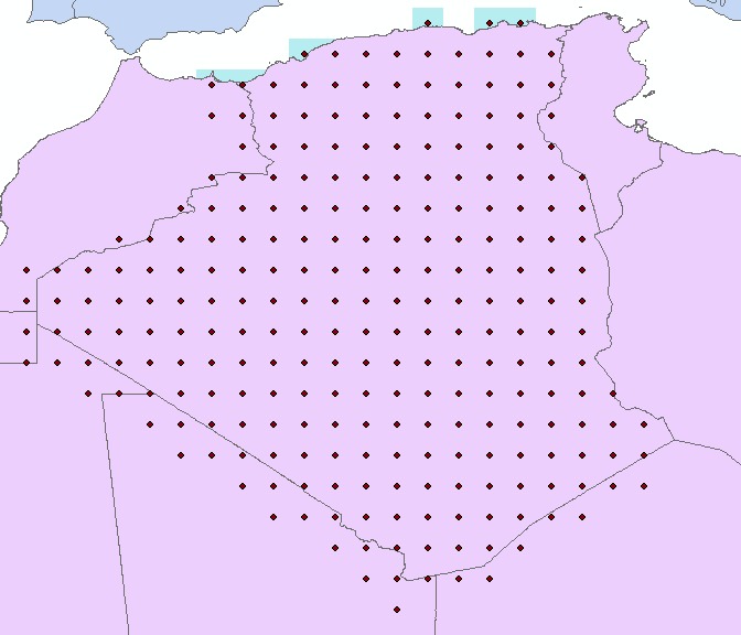
In the attached picture, I have used one country, Algeria, for example.
Apparently, the point layer of Algeria does not fit the country boundaries.
It seems that the point layer should be shifted a bit left to fit its country.This situation happens for all the other countries.
Did I make a mistake in defining the coordinate system or some other issues are ignored by me?
I look forward to hearing from you. Thank you in advance for your kind help!
Best regards
Long
- Mark as New
- Bookmark
- Subscribe
- Mute
- Subscribe to RSS Feed
- Permalink
confirm that both should have a GCS WGS84. In other words, both have coordinates in decimal degrees and have a defined datum of WGS84. Another thought, the number of decimal points will affect the precision and hence placement of the points
How were the points created? It could be that some of the point may be within the extent of the country but not within its bounds... they are two separate things. You can always perform a select by location to only select the points within the bounds and remove all others if that is your intent.
- Mark as New
- Bookmark
- Subscribe
- Mute
- Subscribe to RSS Feed
- Permalink
Dear Dan,
Thank you very much for your answer!
I have checked in both layers' properties and it shows that they both have WGS84. The points are created by 1 degree of latitude X 1 degree of longitude in integer values within a certain country (in my case, Algeria). So there may not be any problem of decimal points issues and there is not any select for within country in its attribute table.
I am very new to GIS, so I am not very sure if this kind of inconsistency happens occasionally or it is not common in ArcGis.
Best regards
Long
- Mark as New
- Bookmark
- Subscribe
- Mute
- Subscribe to RSS Feed
- Permalink
make the values decimals... ie 45. or 45.0 . It is the extent thing I am interested in. If you do a
Select Layer By Location—Help | ArcGIS for Desktop you will get the points that are definitely within the bounds of the country