- Home
- :
- All Communities
- :
- User Groups
- :
- Coordinate Reference Systems
- :
- Questions
- :
- Raster file missing spatial reference information
- Subscribe to RSS Feed
- Mark Topic as New
- Mark Topic as Read
- Float this Topic for Current User
- Bookmark
- Subscribe
- Mute
- Printer Friendly Page
Raster file missing spatial reference information
- Mark as New
- Bookmark
- Subscribe
- Mute
- Subscribe to RSS Feed
- Permalink
Hi all,
Please bear with me, I'm relearning ArcMap after using mapinfo exclusively for the last two years.
I'm trying to work with a raster data set (attached in zip file) sourced from the USGS and having issues working with it as it is missing it's spatial reference information. The raster's metadata includes the following information:
- Map Projection Name: Lambert Azimuthal Equal Area
- longitude of projection center: -100.000000
- latitude of projection center: 45.000000
- false easting: 0.000000
- false northing: 0.000000
- Planar Coordinate Encoding Method: row and column
- coordinate representation:
- abscissa resolution: 1000.000000
- ordinate resolution: 1000.000000
- planar distance units: meters
- coordinate representation:
- geodetic model:
- horizontal datum name: D Shpere ARC INFO
- ellipsoid name: Sphere ARC INFO
- semi major axis: 6370997.000000
- denominator of flattering ration: infinity
I've attempted to manually input the projection centers when setting the raster spacial reference but don't see any change when it runs. I've also attempted to find a complementary projection as Arc only has a polar Lambert Azimuthal Equal Area which does not work in this circumstance.
I've also tried uploading a vector layer (basic US states layer, WGS 1984) with known spatial reference before uploading the raster. That also has no effect on the raster.
Does anyone have any ideas or could help me out?
Solved! Go to Solution.
Accepted Solutions
- Mark as New
- Bookmark
- Subscribe
- Mute
- Subscribe to RSS Feed
- Permalink
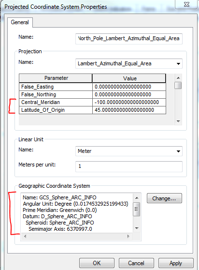
You would have to define a custom projected coordinate system in ArcGIS, but it's certainly do-able. Lambert azimuthal equal area has always supported non-polar cases in ArcGIS for Desktop, and did in Workstation too.
Anyway, here's the well-known text string for the definition:
PROJCS["raster_laz",GEOGCS["GCS_Sphere_ARC_INFO",DATUM["D_Sphere_ARC_INFO",SPHEROID["Sphere_ARC_INFO",6370997.0,0.0]],PRIMEM["Greenwich",0.0],UNIT["Degree",0.0174532925199433]],PROJECTION["Lambert_Azimuthal_Equal_Area"],PARAMETER["False_Easting",0.0],PARAMETER["False_Northing",0.0],PARAMETER["Central_Meridian",-100.0],PARAMETER["Latitude_Of_Origin",45.0],UNIT["Meter",1.0]]
Copy it as a single line to a text file, change the text file's extension to .prj, then you can import it through the raster's property page in ArcCatalog or the Define Projection tool.
Your next question may be on what geographic/datum transformation should be used to convert to NAD83 or WGS84-based coordinate system (or to overlay it with that type of data). There's no predefined transformations between a sphere-based GCS and a geodetic GCS (AKA one based on a true geodetic datum). Try just adding the raster with your other data, ignore any transformation warnings. Does it appear to overlay? Then you're good to go. If it appears to be offset north-south, try adding a custom geographic transformation (there's a tool) between its GCS and NAD83 or WGS84 whatever you're using. Set the method to Geocentric Translation and leave the parameter values set to zeroes.
Melita
- Mark as New
- Bookmark
- Subscribe
- Mute
- Subscribe to RSS Feed
- Permalink
open a blank dataframe
add the raster
right-click on it, select properties, and find the extent area
if the numbers are big-ish, then you have projected data
if you go to the spatial reference/coordinate system area and it says undefined, then it is undefined and needs to be
chances are, that the data are in the lambert azimuthal equal area projection... or they were lying
use the Define projection tool, and define it as such...you will have to crawl around to find it, or search by name
once it is defined, you can do anything with it, like project
- Mark as New
- Bookmark
- Subscribe
- Mute
- Subscribe to RSS Feed
- Permalink
You would have to define a custom projected coordinate system in ArcGIS, but it's certainly do-able. Lambert azimuthal equal area has always supported non-polar cases in ArcGIS for Desktop, and did in Workstation too.
Anyway, here's the well-known text string for the definition:
PROJCS["raster_laz",GEOGCS["GCS_Sphere_ARC_INFO",DATUM["D_Sphere_ARC_INFO",SPHEROID["Sphere_ARC_INFO",6370997.0,0.0]],PRIMEM["Greenwich",0.0],UNIT["Degree",0.0174532925199433]],PROJECTION["Lambert_Azimuthal_Equal_Area"],PARAMETER["False_Easting",0.0],PARAMETER["False_Northing",0.0],PARAMETER["Central_Meridian",-100.0],PARAMETER["Latitude_Of_Origin",45.0],UNIT["Meter",1.0]]
Copy it as a single line to a text file, change the text file's extension to .prj, then you can import it through the raster's property page in ArcCatalog or the Define Projection tool.
Your next question may be on what geographic/datum transformation should be used to convert to NAD83 or WGS84-based coordinate system (or to overlay it with that type of data). There's no predefined transformations between a sphere-based GCS and a geodetic GCS (AKA one based on a true geodetic datum). Try just adding the raster with your other data, ignore any transformation warnings. Does it appear to overlay? Then you're good to go. If it appears to be offset north-south, try adding a custom geographic transformation (there's a tool) between its GCS and NAD83 or WGS84 whatever you're using. Set the method to Geocentric Translation and leave the parameter values set to zeroes.
Melita
- Mark as New
- Bookmark
- Subscribe
- Mute
- Subscribe to RSS Feed
- Permalink
Thank you for the projection text string! Using your suggestion I was able to get my raster to overlay correctly on my states layer after many hours of frustration!
- Mark as New
- Bookmark
- Subscribe
- Mute
- Subscribe to RSS Feed
- Permalink
There's no attachment.
Have you tried this as a custom CRS?
- Mark as New
- Bookmark
- Subscribe
- Mute
- Subscribe to RSS Feed
- Permalink
Whoops 
Thanks for the image, between you and Melita, I was able to get get my raster defined and overlayed onto my states layer correctly!