- Home
- :
- All Communities
- :
- User Groups
- :
- Coordinate Reference Systems
- :
- Questions
- :
- Re: Offset Coordinates
- Subscribe to RSS Feed
- Mark Topic as New
- Mark Topic as Read
- Float this Topic for Current User
- Bookmark
- Subscribe
- Mute
- Printer Friendly Page
Offset Coordinates
- Mark as New
- Bookmark
- Subscribe
- Mute
- Subscribe to RSS Feed
- Permalink
I have an excel file that has XY data in state plane format. The coordinates were taken from a survey plat and each coordinate has its own offset value. Is there an easy way or a tool that I can use that will shift the coordinates to their actual location after the offset is applied?
Thank you!
- Mark as New
- Bookmark
- Subscribe
- Mute
- Subscribe to RSS Feed
- Permalink
Can you provide a simple example of your data? I'm imagining you could add two new columns to your Excel file, calculate the new coordinates into the new columns using x,y offset values from other columns, and plot your plots using those coordinates, but that seems too easy...
- Mark as New
- Bookmark
- Subscribe
- Mute
- Subscribe to RSS Feed
- Permalink
The data has been attached to the post. Thank you for taking a look at it.
- Mark as New
- Bookmark
- Subscribe
- Mute
- Subscribe to RSS Feed
- Permalink
That dataset only has one offset value. Do you have any more information? Simple situation that shows this doesn't work, as is: you're standing at (0,0). I tell you to "Move 10". Where do you go? You need more numbers, or more rules.
- Mark as New
- Bookmark
- Subscribe
- Mute
- Subscribe to RSS Feed
- Permalink
I do not have any more information. The table on the original survey plat only shows what I have provided and then a station value such as 1700+530.387.
- Mark as New
- Bookmark
- Subscribe
- Mute
- Subscribe to RSS Feed
- Permalink
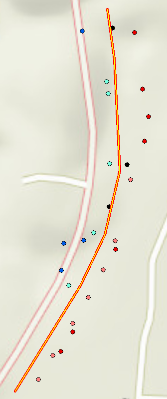
It appears as though your points are in reference to some other line (like I've guessed below, negative offsets blue, positive offsets red). Are you trying to move those points to their position on the line, or what is the objective?
- Mark as New
- Bookmark
- Subscribe
- Mute
- Subscribe to RSS Feed
- Permalink
Most of the locations are "found iron pins" along the roadway you see on the map to the west of the line you have drawn. Once I have the dots in the correct location I can georeference in an image from the survey plat so that I can get the location of easements and right of way boundaries.
- Mark as New
- Bookmark
- Subscribe
- Mute
- Subscribe to RSS Feed
- Permalink
If I understand correctly, your point coordinates are "correct" for some coordinate reference system slightly different from State Plane Meters, like there is an offset of 30m or so (as I've mapped above). The offset value in your spreadsheet corresponds to the offset from the road center, where zero would be the center of the road. Unfortunately, as they are, the coordinates don't correspond to the road in terms of regular State Plane Meters. Does your survey plan give any other hints about the coordinate reference system?
- Mark as New
- Bookmark
- Subscribe
- Mute
- Subscribe to RSS Feed
- Permalink
No it does not.
- Mark as New
- Bookmark
- Subscribe
- Mute
- Subscribe to RSS Feed
- Permalink
I think that link is discuss same your problem: