- Home
- :
- All Communities
- :
- User Groups
- :
- Coordinate Reference Systems
- :
- Questions
- :
- Re: importing survey data
- Subscribe to RSS Feed
- Mark Topic as New
- Mark Topic as Read
- Float this Topic for Current User
- Bookmark
- Subscribe
- Mute
- Printer Friendly Page
importing survey data
- Mark as New
- Bookmark
- Subscribe
- Mute
- Subscribe to RSS Feed
- Permalink
Hi all,
I have received an hardrive from a geophysical survey with the following data:
MBES- DTM : Density xyz xyz file
DTM xyz xyz file
Slope xyg xyz file
MAG : text file
SSS: Mosaic: .tif and .twf file
Raw data: xtf data
SBP: .sgy files
I do not know how to import them into ArcGIS 10.2 Desktop and I do not have 3D Spatial Analyst tool. (But I have QGIS which sometimes makes the job).
Can anyone help me?
Thanks a lot
F.
- Mark as New
- Bookmark
- Subscribe
- Mute
- Subscribe to RSS Feed
- Permalink
The xyz files will probably be text. So open them in something like Notepad++ and have a look.
tif is an image so that should be no problem.
No idea what a *.sgy file might be, but again, have a look at it in a text editor just to see what the contents are.
And, of most importance, you will need to know, up front, what the coord sys is for all this stuff.
- Mark as New
- Bookmark
- Subscribe
- Mute
- Subscribe to RSS Feed
- Permalink
Morning Neil,
thanks for your answer. I had a look at the data in a notepad as suggested.
Please see below the contents:
this is the kind of data into the DTM folder :
.jpg)
I was expecting a column with something as depth and I cannot see it.
This is the content of the SLOPE folder:
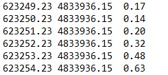
With this one I have another "issue". When I paste into the excel with the "Use Text Import Wizard" to keep the separation of the columns, I got a message "Text extends beyond worksheet. Some text will be lost".
I really do not know what to do as it doesn't paste all the data.
I hope you can help.
Thanks
F
- Mark as New
- Bookmark
- Subscribe
- Mute
- Subscribe to RSS Feed
- Permalink
That first table looks a bit odd. Where's the separator? Looks like they are just merging into each other.
Possibly the first row should look like :
625079.50 4835170.50 2.41But is that Z (3rd column) a realistic number for this area?
The second one seems to at least have a tab or space separating the columns.
Note that, for this snippet, the X is exactly spaced 1m(?) apart. Check the Y's as well.
Perhaps, the linefeeds / newlines are not being interpreted correctly when you import, and it is all coming across as one very long line, that's why you run out of columns.
- Mark as New
- Bookmark
- Subscribe
- Mute
- Subscribe to RSS Feed
- Permalink
Dear Neil,
thank you very much for your suggestions.
I have found out that other DTM xyz data are not merged as the example I sent to you. So probably it has been an issue for just one acquisition.(I will check with the Survey company).
As I have mentioned before I do not have the 3d Spatial Analyst tool. As already said when I paste all the data into excel I run out the rows because the data rows are more than what excel can handle. So I have tried to split all the data in different sheets for the same excel document (which requires lots of patient). When I try to save the document as Excel 97-2003 which is the excel version that GIS is able to open I get another message of not compatibility. So again I cannot import my excel into GIS. I do not have MS Access too. So do you have any suggestion to copy these data into GIS? (maybe with another version of excel?)
Thanks a lot for all your help.
F.
- Mark as New
- Bookmark
- Subscribe
- Mute
- Subscribe to RSS Feed
- Permalink
Probably the quickest is to use some python magic.
If you can post some example files here, then we can import them to points.
But, if you haven't got SA, then turning them back into images will be a problem.
Do you know what the coordinate system is yet?
- Mark as New
- Bookmark
- Subscribe
- Mute
- Subscribe to RSS Feed
- Permalink
Dear Neil,
thanks for coming back to me. I am in the process of asking to the survey company to deliver the data in a different format which is readable in GIS.
Before that, could you please confirm me that the GIS cannot read other excel versions rather than Excel 97-2003?
Is it true that even if I save the document into .csv I won't solve the problem of running out the excel's rows?
If I would have the 3d and spatial analyst tool. would be any difference? Will I be able to read the .xyz directly from GIS without importing in excel?
Thanks once more for your support.
F
- Mark as New
- Bookmark
- Subscribe
- Mute
- Subscribe to RSS Feed
- Permalink
Regarding the column thing.
I just suggested that, because of the spacing / tabs or whatever, the excel importer was not seeing the data correctly and was trying to import the whole file as a series of column (ie not row by row), that's why you ran out of columns.
Ask them to send you it in standard csv (comma separated) style. Then, hopefully excel would be able to interpret it correctly.
And, by the way, you should be able to import csv directly into Arc without going through excel.
When you get it into a point feature class, you will need spatial analyst to "rasterise" it.
And, because these points seem to be on a very regular grid, it looks to me as if this is a "text dump" of a raster anyway. Each row represents the cell centre coordinates and value.
Is this coming from Geosoft? If so, get them to send just the original geosoft "*.grd" files. This is Geosoft's own propriety raster format. You can download a plugin from geosoft for ArcGIS, which will enable you to read the raster, then save to an Arc format like file geodb or tiff.
And, don't forget about the coordinate system for this data.
- Mark as New
- Bookmark
- Subscribe
- Mute
- Subscribe to RSS Feed
- Permalink
Hi Neil,
thanks for your prompt reply.
I tried to paste into excel the data that in the .xyz file were looking separated rather than the one merged. But I still got the issue of running out rows (to me looked like the importing was alright) is just that they are millions of data and as far as I know excel run out rows at some point. That is why I tried to split the data in multiple sheets (but this is crazy enough) and afterwards I have the problem of saving in a compatibility mode which anyway doesn't allow me to do the job.
I will try to figure out if they can send the .csv files and hopefully I will be able to open directly from the ArcGIS.
My idea is to skip the problem of not having the 3d tool:
- importing the xyz into ArcGIS
- Create a feature
- Interpolate it via QGIS
I have used QGIs for interpolation once (but I managed to achieve that because I already had a points shapefile rather than a xyz file).
I do not know about Geosoft. I will try to find out that one as well.
Thanks a lot and have a nice day.
F.