- Home
- :
- All Communities
- :
- User Groups
- :
- Coordinate Reference Systems
- :
- Questions
- :
- Re: How to find the unknown coordinates reference ...
- Subscribe to RSS Feed
- Mark Topic as New
- Mark Topic as Read
- Float this Topic for Current User
- Bookmark
- Subscribe
- Mute
- Printer Friendly Page
How to find the unknown coordinates reference system for my map data
- Mark as New
- Bookmark
- Subscribe
- Mute
- Subscribe to RSS Feed
- Permalink
I have several shapesfiles which perfectly overlay but the coordinates reference system is unknown. I need to overly these with other data in a differetn coordinate system. The coordinate extent is quite unique. I tried initially to overlay with several projected and geographic coordinates systems associated with the area out of which two showed very close displacement (about 60m). Next i tried different datum with one of the 'promising' coordinates reference systems (a geographic coordinates system) and also change the units but same results. Attached is a clip of two of the coordinate extents. I am yet to try the second 'promising' CRS but decided to put it out just in case i am missing something
- Mark as New
- Bookmark
- Subscribe
- Mute
- Subscribe to RSS Feed
- Permalink
Rebecca, I am trying to project from the current defined CRS (Leigon_Transverse_mercator) to a new one (Ghana meter grid). There are only slight differences between the two, both uses the same Geographic coordinates system (GCS_ Leigon), projection (transverse mercator), datum (D_Leigon), but different units; one is in meters and the other mm, central meridian and latitude of origin are different. All others the same ie false northern and eastern, scale factor. So far the transformation comes with the error message 'transformation is invalid'. Any ideas where i need to improve?
- Mark as New
- Bookmark
- Subscribe
- Mute
- Subscribe to RSS Feed
- Permalink
Hi Kofi,
That message occurs when either the input or output geographic coordinate systems don't match the internal definitions. So the software sees them as "different" so thinks that there should be a geographic/datum transformation OR there's no transformations available between two "known" GCS.
A workaround if the input/output GCS are supposed to be the same is to add the data to ArcMap and set the data frame to the coordinate system you want to convert to.
Ignore any geographic/datum transformation warning message.
Right-click the data layer in the table of contents and choose data, export data. In the dialog, set it to use the data frame's coordinate system and export the data.
Melita
- Mark as New
- Bookmark
- Subscribe
- Mute
- Subscribe to RSS Feed
- Permalink
As Melita says, if both underlying GCS / datums are Leigon, then no transformation is necessary.
The WKID for Ghana_Metre_Grid is 25000.
EPSG has this definition, the units are metres (obviously). Why are you talking about mm?
And, quite what is the definition of your starting coord sys. Also the older "Accra" system was in Gold Coast feet.
- Mark as New
- Bookmark
- Subscribe
- Mute
- Subscribe to RSS Feed
- Permalink
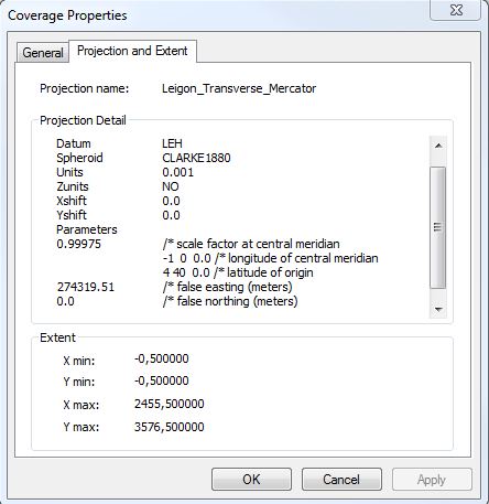
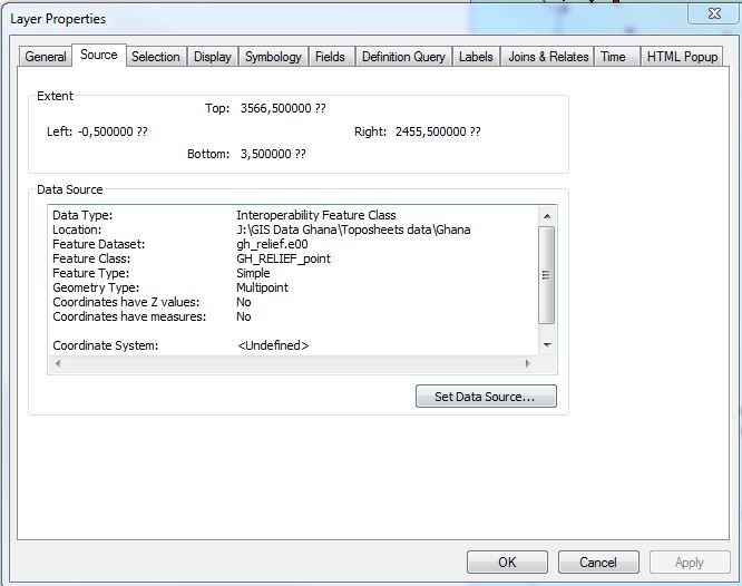
it was based on this that i developed the projection coordinates system and as you can see the units is 0.001 which when i checked was mm. I have tried Melita's suggestion, but when i tried to open or load in arcmap nothing showed up even when i zoomed to layer or the full extent. The attribute table however is fully populated.
- Mark as New
- Bookmark
- Subscribe
- Mute
- Subscribe to RSS Feed
- Permalink
You use a comma as a decimal separator.
the xmin to xmax is -0.5 to 2455.5 whatevers
the ymin to ymax is -0.5 to 3576.5 whatevers
the whatevers aren't millimeters... they aren't degrees, unless the study area is small ( is 2.455 ish km wide) then the units aren't meters...
perhaps 0.001 represents a fraction of a decimal degree?
this leads me to question again,.... are thes values representative of the number of cells in the x and y directions.
- Mark as New
- Bookmark
- Subscribe
- Mute
- Subscribe to RSS Feed
- Permalink
Dan, i get your drift, but this is a vector file so how do i get the number of cells in the x,y direction. Or maybe i should convert to raster? I called the source of the data and he was of very little help except to suggest that its possible the document has been corrupted.
- Mark as New
- Bookmark
- Subscribe
- Mute
- Subscribe to RSS Feed
- Permalink
It looks like the file you have might have been converted to vector from raster. I suppose that has been ruled out already
- Mark as New
- Bookmark
- Subscribe
- Mute
- Subscribe to RSS Feed
- Permalink
Kofi Lartey that extent really looks like it the vector data came from an unprojected raster dataset of size 2456 rows x 3577 columns. If you have no idea where this data came from and can identify some tie points, you may want to try the Transformation toolbar to warp your data to match some other dataset.
- Mark as New
- Bookmark
- Subscribe
- Mute
- Subscribe to RSS Feed
- Permalink
I had to go track down an ArcInfo workstation book to look up the "Units 0.001" definition. A custom unit's value is defined as units per metre. So that stands for kilometres, not millimetres. Even with that information, the coordinate extents still don't make sense unless the data covers Ghana plus a bunch of countries to the north and east.
If I very roughly check Ghana's extents against the 2455x3576 "cell sizes", I get around 5 meters per "cell". That's not too bad for a raster that might have represented soil or rainfall data.
I don't know if you're willing to send one of the files (shapefile, .e00, whatever) to me (mkennedy at esri dot com) so I can look at it.
Melita
- Mark as New
- Bookmark
- Subscribe
- Mute
- Subscribe to RSS Feed
- Permalink
Okay, thanks to Kofi Lartey, I got the e00 files. One, a country boundary file with at least level 1 administrative districts, is in a custom projected coordinate system, complete with a custom ellipsoid.
Projection TRANSVERSE
Datum USER_DEFINED 0.000 0.000 0.000 0.0000 0.0000 0.0000 0.0000
Zunits NO
Units FEET
Xshift 0.0000000000
Yshift 0.0000000000
Parameters 6378295.0000000000 6356746.0000000000
0.99975000 /* scale factor at central meridian
-1 0 0.000 /* longitude of central meridian
4 40 0.000 /* latitude of origin
274320.00000 /* false easting (meters)
0.00000 /* false northing (meters)
The projection parameters are the Ghana National Grid / Metric Grid (although the false easting differs by about 0.5 meter). The custom ellipsoid has a flattening around 1/295.9903. The custom ellipsoid is close the "War Office" so there may be a Gold Coast foot/metre conversion issue.
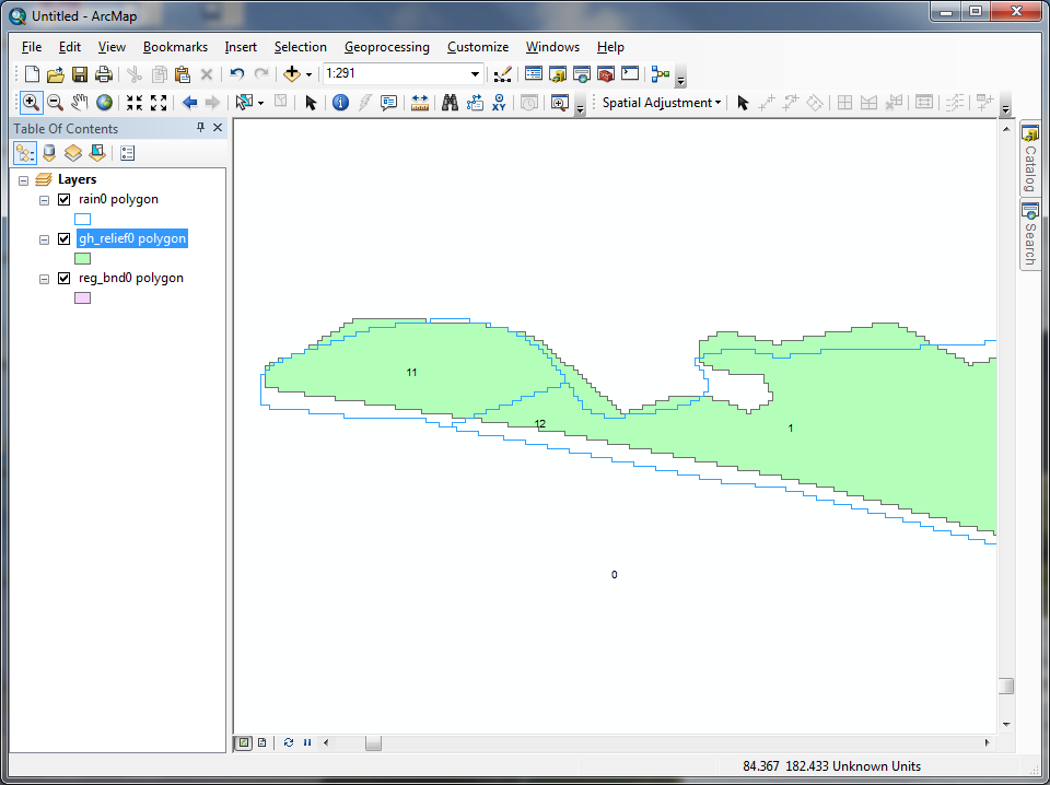
Anyway, the other two coverages are definitely converted from rasters. Here's a close-up:
Also complicating the issue is that these two files don't share the same country boundary. There could be a datum difference between them, but the offsets are not regular, so it's hard to say for certain.