- Home
- :
- All Communities
- :
- User Groups
- :
- Coordinate Reference Systems
- :
- Questions
- :
- Re: Displaying two reference grids in one map (Lay...
- Subscribe to RSS Feed
- Mark Topic as New
- Mark Topic as Read
- Float this Topic for Current User
- Bookmark
- Subscribe
- Mute
- Printer Friendly Page
Displaying two reference grids in one map (Layout view) - UTM reference grid is incorrect - Why?
- Mark as New
- Bookmark
- Subscribe
- Mute
- Subscribe to RSS Feed
- Permalink
- Report Inappropriate Content
Hello,
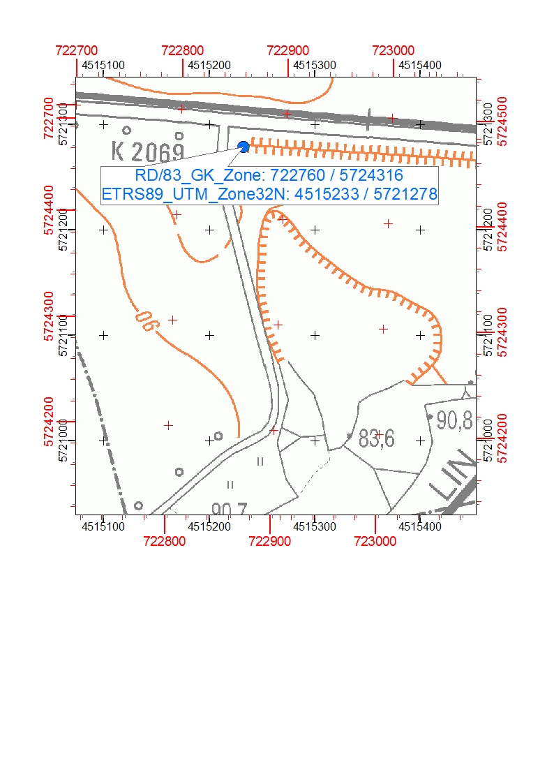
we need to display two coordinate systems as a reference grid in our maps: RD/83_GK_Zone4 and ETRS89_UTM_Zone32N. The layout is shown in the picture below also including a verification point. The GK grid is displayed correctly but the UTM grid is incorrect. There is a shifting as you can see comparing the coordinates of the verification point with the grid coordinates.
Does anyone has an idea how to solve that problem? It seems that just the displayed UTM reference grid is incorrect. The location is in Saxony-Anhalt.
Thanks for your help!
- Mark as New
- Bookmark
- Subscribe
- Mute
- Subscribe to RSS Feed
- Permalink
- Report Inappropriate Content
Have you confirmed the datum for each? A different datum or an improperly defined datum can account for a shift.
I don't know what datum options you have there, but I do know that UTM has a number of datum references
- Mark as New
- Bookmark
- Subscribe
- Mute
- Subscribe to RSS Feed
- Permalink
- Report Inappropriate Content
The datum for RD/83_GK_Zone_4 is defined as D_Rauenberg_1983 and for ETRS1989_UTM_Zone32 it is D_ETRS_1989. It is automatically defined after choosing the coordinate systems. do you think there is a transformation problem? but i'm actually not sure how the transformation works when displaying two different reference grids..
- Mark as New
- Bookmark
- Subscribe
- Mute
- Subscribe to RSS Feed
- Permalink
- Report Inappropriate Content
If you were in North America, I would have an answer  but if you were given an option of a datum transformation and were offered one, you should use it. I don't know what applies in your case. A datum essentially describes the shape of earth at a point in time meaning that if the parameters used to describe its shape globally or locally change, then the coordinate values for a location must change if the object doesn't move. You will have to investigate this further on your end, or I will flag MKennedy-esristaff for some definitive help.
- Mark as New
- Bookmark
- Subscribe
- Mute
- Subscribe to RSS Feed
- Permalink
- Report Inappropriate Content
Thanks you for your help. I suppose it's an ArcGIS problem. For my dataframe I defined the RD/83_GK_Zone_4 coordinate system - Displaying the RD/83 as a reference grid works fine. But when I display an additional reference grid (UTM) it is incorrect. So I supposed there is a transformation problem between RD/83 and UTM. But reffering to the reference grids I have no further possibilities of adjustement (as far as I think).
But maybe your friend Melita Kennedy has some further information!?
- Mark as New
- Bookmark
- Subscribe
- Mute
- Subscribe to RSS Feed
- Permalink
- Report Inappropriate Content
In ArcMap, yes, there's a bug/known limit that the grids and graticule wizard doesn't handle geographic/datum transformations. So a grid or a graticule in a 2nd GCS is not displayed properly. One thing to try is to use the tools instead (Makes Grids and Graticules layer tool in the cartography toolset). They create the grids and graticule differently.....although a Technical Support contact says that doesn't work either. She says you would have to create a second data frame in the other PCS/GCS create it there, then overlay it exactly in the layer frame.
Another possibility is to create the grid with Fishnet tool but then you have to label it yourself.
- Mark as New
- Bookmark
- Subscribe
- Mute
- Subscribe to RSS Feed
- Permalink
- Report Inappropriate Content
is there a bug number reported for this?
- Mark as New
- Bookmark
- Subscribe
- Mute
- Subscribe to RSS Feed
- Permalink
- Report Inappropriate Content
Ask me the hard questions, why doncha? I'm looking for it.
EDIT: Here's the bug: NIM004421
The low number means it was likely ported from the previous bug system, so it's existed for a long time...originally logged in 2005.
Melita
- Mark as New
- Bookmark
- Subscribe
- Mute
- Subscribe to RSS Feed
- Permalink
- Report Inappropriate Content
Melita, thanks for your information. That was quite helpful. At least, I finally know how to handle it and that it is not a user's mistake.
Karin