- Home
- :
- All Communities
- :
- User Groups
- :
- Coordinate Reference Systems
- :
- Questions
- :
- Re: Define projection problem
- Subscribe to RSS Feed
- Mark Topic as New
- Mark Topic as Read
- Float this Topic for Current User
- Bookmark
- Subscribe
- Mute
- Printer Friendly Page
Define projection problem
- Mark as New
- Bookmark
- Subscribe
- Mute
- Subscribe to RSS Feed
- Permalink
Hi,
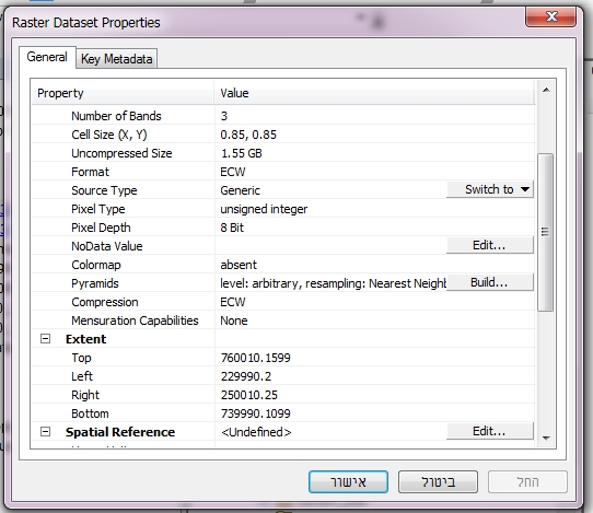
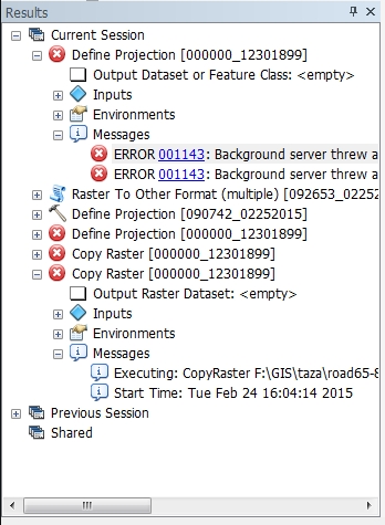
i have an ECW raster that have no spatial reference. when i try to use the tool "defined projection" to define it i get an errors num. 001143 . thanks for any help.
- Mark as New
- Bookmark
- Subscribe
- Mute
- Subscribe to RSS Feed
- Permalink
Did you ever find a solution to this? I have an ecw file and I cannot define the projection.
- Mark as New
- Bookmark
- Subscribe
- Mute
- Subscribe to RSS Feed
- Permalink
This problem still gets down to file permission problems on the system where the ecw exists.
Just check using the normal windows tools.
Also could try importing the ecw into a file geodatabase, and define the projection there using the properties page in ArcCatalog.
- Mark as New
- Bookmark
- Subscribe
- Mute
- Subscribe to RSS Feed
- Permalink
We are having the same problem with ECWs. It is a common problem that started with our switch to ArcGIS 10.3 from 10.2. We can define the projection fine in 10.2 and it shows up in the correct spot in 10.2 but will not show up in the same spot in 10.3 with the same data frame parameters. This is a bug imo.
- Mark as New
- Bookmark
- Subscribe
- Mute
- Subscribe to RSS Feed
- Permalink
I can find three reported bugs for this problem for different software. The one for ArcGIS for Desktop is BUG-000091720 and there's a related one,BUG-000083374, which looks like has been fixed for 10.4.1. There's a similar one for ArcGIS Pro: BUG-000083375.
Melita
- Mark as New
- Bookmark
- Subscribe
- Mute
- Subscribe to RSS Feed
- Permalink
I checked on these bug numbers again. All three have both been marked as-designed (two in July 2016 and the other about a year ago) with this statement in the 2nd one: "The ECW sdk has been updated, to take the projection information in the dataset and use that. This was not being done in 10.2. Hence the prj file is not used but instead the projection info in the dataset is given precedence. This is as designed."
By SDK, I assume that they mean the code that handles ECW as a raster type. So if there was a discrepancy between the internal coordinate system/georeferencing information versus the external (prj file and world file?) that could be where the offsets are coming from. If you have ECW and you're sure this isn't the problem, contact techsupport again, reference the bug numbers and say you think there's a different problem.
Melita
- Mark as New
- Bookmark
- Subscribe
- Mute
- Subscribe to RSS Feed
- Permalink
This bug is not fixed in 10.4.1. My ECWs still show up shifted compared with using 10.2. The same image in .sid and tiff format stays the same between versions.
- Mark as New
- Bookmark
- Subscribe
- Mute
- Subscribe to RSS Feed
- Permalink
The bugs that made it to the fixed list are here http://downloads.esri.com/support/downloads/other_/1041-IssuesAddressedList.pdf
and it was surrounded in 10.4 http://downloads.esri.com/support/downloads/other_/104-IssuesAddressedList.pdf
So watch for the next release unless he lists are incomplete.
- Mark as New
- Bookmark
- Subscribe
- Mute
- Subscribe to RSS Feed
- Permalink
This bug is not fixed in 10.5 pre-release edition. My ECWs still show up shifted compared with using 10.2. The same image in .sid and tiff format stays the same between versions.
- Mark as New
- Bookmark
- Subscribe
- Mute
- Subscribe to RSS Feed
- Permalink
I had this problem in 10.4.1 as well but found that Define Projection worked in ArcGIS Pro 2.3.
In 10.4.1, neither the Define Projection tool or the Edit feature in the raster properties worked for setting the projection on an old .ecw file in ArcMap and ArcCatalog 10.4.1. There were no read/write or other permission problems and I tried copying/moving the file to different file locations to no avail.
- « Previous
-
- 1
- 2
- Next »
- « Previous
-
- 1
- 2
- Next »