- Home
- :
- All Communities
- :
- User Groups
- :
- Coordinate Reference Systems
- :
- Questions
- :
- Re: Custom Geographic Transformation Logic?
- Subscribe to RSS Feed
- Mark Topic as New
- Mark Topic as Read
- Float this Topic for Current User
- Bookmark
- Subscribe
- Mute
- Printer Friendly Page
Custom Geographic Transformation Logic?
- Mark as New
- Bookmark
- Subscribe
- Mute
- Subscribe to RSS Feed
- Permalink
Hi,
I need help on understanding the logic in setting up and using custom geographic transformations in ArcGIS Pro. I think I've read everything I was able to find online incl. several issues here on GeoNet. I would like to take advantage of a Custom Geographic Transformation in the "Project"-geoprocessing tool or as an alternative in the "Copy Feature"-tool (Environments-part) in Model Builder. If ESRI were to implement an "Epoch"-parameter when converting between WGS84 and ETRS89 making it possible to specify Year (WGS84 and ETRS89 are getting more and more different (I think it is around 60 centimeters currently) we would not have to set up our own custom transformations but I don't know if there are any plans on implementing this?
I've created a gtf-file using the "Create Custom Geographic Transformation"-tool (Position Vector containing 7 parameters) and the gtf-file gets created and is found in %appdata%\ESRI\ArcGISPro\ArcToolbox\CustomTransformations. I am able to find, apply and take advantage of the custom transformation in Map Properties (please refer to Map_Properties.jpg) and the transformation seems to work but when exporting data I am not able to apply the custom transfromation in order to get a dataset containing transformed coordinates. I noticed that in ArcMap the user is asked whether or not to use the coordinate system definition of the data frame when exporting and in this case the data gets transformed but unfortunately not in ArcGIS Pro.
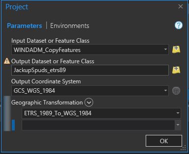
I am also able to find and specify the transformation in the Project-tool but for some reason it is saying that it is invalid (please refer to Project-error-message.jpg). Does the Project-tool compare type of custom transformations with coordinate systems in such a way that I am only allowed to apply e.g. a Geocentric Translation when converting between ETRS89 and WGS84 and not the Position Vector type of transformation? It seems to accept the "standard" custom transformation supplied with the software (please refer to Project-message.jpg). What is the difference between these two transformations? Is the ETRS_1989_To_WGS_1984 a .gsb-file?
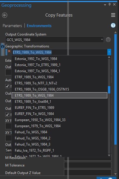
As an alternative I was thinking about specifying it in the Environments-part of the Copy/Copy Feature-tool but in this case the custom transformation for some reason doesn't show up in the drop down box (please refer to Copy_Environments.jpg.). What does it take for my custom transformation to show up in this drop down list? The "standard" ETRS_1989_To_WGS_1984 seems to also be included in this list. Is the ETRS_1989_To_WGS_1984 a .gsb-file and if that is the case how do I create a .gsb-file? I haven't been able to find out how by using google 🙂
A lot of questions; I know; In short I would just like to know how to take advantage of a custom transformation (Position Vector) in ArcGIS Pro when transforming data between WGS84 and ETRS89? 🙂
Kind regards,
Martin
- Mark as New
- Bookmark
- Subscribe
- Mute
- Subscribe to RSS Feed
- Permalink
We are planning on implementing time-based transformations. Mostly it's figuring out how to incorporate the epoch parameter, intraframe files, etc. into the software. I don't know which release it will be in.
If you want a transformation to show up in the geoprocessing environments, you have to update the core.xml file that's located in C:\Program Files\ArcGIS\Pro\Resources\Help\gp\Environments. It's a hard-coded list and doesn't pick up any custom transformations. An entry looks like:
<GPCodedValueDomainProperty xsi:type="typens:GPCodedValueDomainProperty">
<Name>Adindan_To_WGS_1984_1</Name>
<Value xsi:type="typens:GPString">
<Value>Adindan_To_WGS_1984_1</Value>
</Value>
</GPCodedValueDomainProperty>
so it's not difficult to add entries. Make sure you run Notepad (or another edit program) as an Administrator, and you'll have to restart ArcGIS Pro.
Is there more than one point in the feature class? We had a problem in the Project tools when there's only one point.
Melita
- Mark as New
- Bookmark
- Subscribe
- Mute
- Subscribe to RSS Feed
- Permalink
Hi Melita and Happy New Year.
Any updates on this problem/challenge? I now realize that I replied back to Lars and not to you so perhaps you did not see my updates below.....
It was me filing this question originally and not Lars but it turned out that on the same machine even though I overall was logged in using my ESRI Online the user session on GeoNet was still Lars' 😞
I still have to go back and forth to using ArcMap in order to workaround this issue and I would really like to avoid this and only use ArcGIS Pro.
Kind regards,
Martin
- Mark as New
- Bookmark
- Subscribe
- Mute
- Subscribe to RSS Feed
- Permalink
Thanks for the quick reply, Melita. So you would recommend performing the transformation using Copy Feature instead of trying to use Project, right?
I've now added an entry in the "C:\Program Files\ArcGIS\Pro\Resources\Help\gp\Environments\core.xml":
<GPCodedValueDomainProperty xsi:type="typens:GPCodedValueDomainProperty">
<Name>Zanderij_To_WGS_1984</Name>
<Value xsi:type="typens:GPString">
<Value>Zanderij_To_WGS_1984</Value>
</Value>
</GPCodedValueDomainProperty>
<GPCodedValueDomainProperty xsi:type="typens:GPCodedValueDomainProperty">
<Name>Yoff_To_WGS_1984_2</Name>
<Value xsi:type="typens:GPString">
<Value>Yoff_To_WGS_1984_2</Value>
</Value>
</GPCodedValueDomainProperty>
<GPCodedValueDomainProperty xsi:type="typens:GPCodedValueDomainProperty">
<Name>WGS84_to_ETRS89_2018</Name>
<Value xsi:type="typens:GPString">
<Value>WGS84_to_ETRS89_2018</Value>
</Value>
</GPCodedValueDomainProperty>
</GPDomainPropertiesArray>
</GPDomain>
</GPDomainArray>
</Domain>
And I've made sure to restart ArcGIS Pro(vers. 2.2) after making and saving the modifications but for some reason the new entry does not show up in the list. I've also tried to switch the last two original entries (Yoff_To_WGS_1984_2 <-> Zanderij_To_WGS_1984) around but this change does not "kick in" either. Do not know if the list is always shown sorted alphabeticly or following the order in the file. Is the list cached somewhere that I need to delete/clean out? Also if we figure out why the changes aren't reflected and the new entry eventually shows up in the list where does the software "go" to find the information needed in order to perform the referenced transformation; the %appdata%\ESRI\ArcGISPro\ArcToolbox\CustomTransformation-folder or do I need to add the .gtf-information somewhere else perhaps in a different format?
Kind regards,
Martin
- Mark as New
- Bookmark
- Subscribe
- Mute
- Subscribe to RSS Feed
- Permalink
Oh, and it sounds really good with regards to adding an Epoch-option:-)
And the feature class has several point features and not only one. I am just curios to what type of validation it is performing that makes it "decide and complain" about my custom Position Vector transformation being an "invalid geographic transformation".
- Mark as New
- Bookmark
- Subscribe
- Mute
- Subscribe to RSS Feed
- Permalink
Hello Martin,
I'm sorry for the delay in responding. It's very possible I left out a step when update the core.xml file. Try running this command in the arcpy window:
arcpy.gp.command("bootstrap xml environment")
Melita