- Home
- :
- All Communities
- :
- User Groups
- :
- Coordinate Reference Systems
- :
- Questions
- :
- Coordinates transformation accuracy
- Subscribe to RSS Feed
- Mark Topic as New
- Mark Topic as Read
- Float this Topic for Current User
- Bookmark
- Subscribe
- Mute
- Printer Friendly Page
Coordinates transformation accuracy
- Mark as New
- Bookmark
- Subscribe
- Mute
- Subscribe to RSS Feed
- Permalink
I need coordinates transformation for Point Feature Clases. Situation:
I have imported points in local projected coordinate system. Now I need to get points coordinates in geographic coodinate system. I need to have each point coordinates in attribute table. So, in attribute table I use calculate geometry function. It seems that after I calculate coodinates to geographic system (DMS), seconds parts become incorrect. Is it possible that an error accurs while making a transformation? Does anyone has any other comment on this question?
Coordinates example:
Local system: 6207549.78, 318656.45
WGS system after transformation: 21°5'41,58"E 55°58'4,13"N
Result using different calculator: 21°5'41,64"E 55°58'4,08"N
- Mark as New
- Bookmark
- Subscribe
- Mute
- Subscribe to RSS Feed
- Permalink
"Is it possible that an error occurs while making a transformation?" Yes, the positional accuracy of a transformation from one coordinate system to another will result in a positional error. This is the reason why using the correct transformation is important as the correct transformation method will minimise the positional error.
From my calculation the distance between the two latitude and longitude values is approximately 186 cm.
I think the next question is: Does your data require positions more accurate than that?
- Mark as New
- Bookmark
- Subscribe
- Mute
- Subscribe to RSS Feed
- Permalink
Yes, I need more accurate value.
Maybe you could suggest how to make correct transformation and minimise this error?
- Mark as New
- Bookmark
- Subscribe
- Mute
- Subscribe to RSS Feed
- Permalink
Can you provide the name and details of the local system and which system you are trying to transform to?
- Mark as New
- Bookmark
- Subscribe
- Mute
- Subscribe to RSS Feed
- Permalink
From LKS1994 Lithuania TM to WGS84
- Mark as New
- Bookmark
- Subscribe
- Mute
- Subscribe to RSS Feed
- Permalink
If you are working within this extent:
Max Latitude:53.8900
Min Latitude:19.0200
Max Longitude:56.4500
Min Longitude:26.8200
The LKS94 to WGS84 Transformation should be valid and because LKS94 is derived from ETRS89 and coincident to WGS 84 within 1 metre. This transformation has an accuracy within 1 meter.
See https://epsg.io/1283 for further detail on the transformation...
- Mark as New
- Bookmark
- Subscribe
- Mute
- Subscribe to RSS Feed
- Permalink
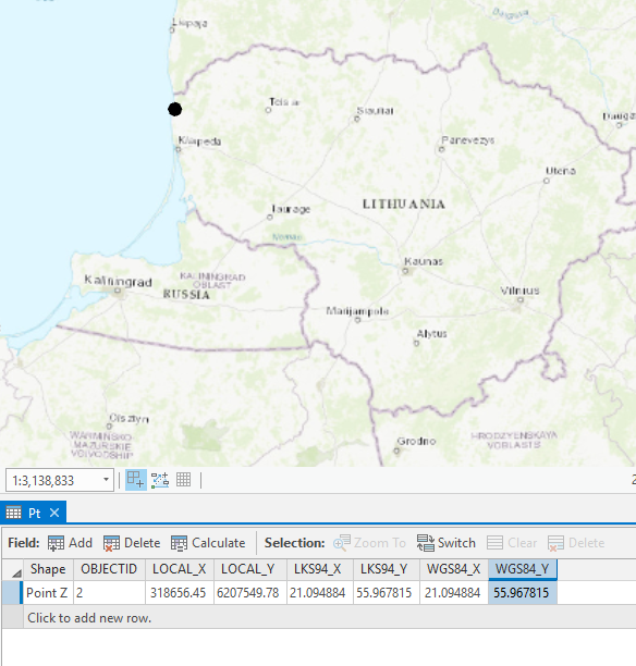
Iren Iren Thanks you for indicating this was helpful. For your information I have taken a screenshot of the calculations conducted using the LKS94 to WGS84 transformation as described above...the resulting decimal degree outputs for both LKS94 and WGS84 are the same to the 6th decimal point which is under 1m accuracy...
- Mark as New
- Bookmark
- Subscribe
- Mute
- Subscribe to RSS Feed
- Permalink
I am a bit suspicious because when I convert the "other converter's" values to decimal degrees I get:
21.0949
55.9678
I suspect there is a difference in precision in the two conversions. Can you post a link to the other converter?
Melita
- Mark as New
- Bookmark
- Subscribe
- Mute
- Subscribe to RSS Feed
- Permalink
It'll be interesting to see the other converted as the longitudinal (X) value is out by small amount: 21.094884 vs 21.0949. Like you say this could be a precision and/or rounding problem...
