- Home
- :
- All Communities
- :
- User Groups
- :
- Conservation GIS
- :
- Documents
- :
- Sabrina Costa da Silva, Brazil
- Subscribe to RSS Feed
- Mark as New
- Mark as Read
- Bookmark
- Subscribe
- Printer Friendly Page
Sabrina Costa da Silva, Brazil
Sabrina Costa da Silva, Brazil
Sabrina Costa da Silva, Instituto BioAtlântica, Brazil
 Organization Web site: www.bioatlantica.org.br Main email
2012 Publication: "SUSTAINABLE FOREST MOSAICS" report, “Writings of The Dialogue” Vol 3, 2012 Integrated biodiversity monitoring and forest restoration guidelines
2012 Scholar Profile:
How are you currently learning GIS? My first contact with geotechnologies was during the Biological Sciences graduation course in 2006, when I started an internship at the GIS lab at Santa Ursula University. At that time I knew nothing about GIS and I started to learn the tools from the basics, using Idrisi Kilimanjaro software. My advisor at the time, PhD Philip Conrad Scott, taught me beginning concepts of Geographic Information Systems and cartography, and eventually I learned to use the different software tools in self-taught ways, always doing a lot of tests and using the "help" tool. I also researched a lot at the internet and talked with the laboratory colleagues that helped me to resolve my questions in the use of GIS software.
When I started working at IBio in early 2008, I was finally able to attend a basic training in ArcGis at Imagem
During the years that followed I learned many other tools in ArcGis and knew a little about other software, also trying to learn by myself, using internet tutorials, and help from the following mentors and teachers:
Philip Conrad Scott – Laboratório de Aquicultura e SIG
Alexandre Uezo (2006 Scgis Scholar) Instituto de Pesquisas Ecológicas (IPE)
Clinton Jenkins (Current SCGIS Member)– Nicolas School of the Environment, Duke University
Such tools are very important to the refinement of the information that I use in my work, for example, to support the strategies concerning: the planning of watershed, the choice of the areas to restore from spatialization of the criteria related to the current legislation, determination of potential areas for the creation of ecological corridors, priority areas for the establishment of programs to payment for environmental services, identify potential regions to work on encouraging the creation of protected areas, among others.
Brazil is considered a megadiversity country, with at least four regions of global conservation importance: the Amazon, Pantanal, Cerrado and Atlantic Forest. The Atlantic Forest is one of the biomes of the greatest biodiversity of the planet, considered a hotspot for conservation, by its high degree of endemism and threat of species extinction. Successive cycles of soil use and natural resources, resulting to the population growth that transformed the Atlantic Forest in one extensively fragmented forest.
Over the past 150 years, Brazil has executed a pioneering role in the development of the politics for pro-active and effective environmental conservation and ecological restoration initiatives. The IBio has articulated a network of partnerships with various government institutions, NGOs, research centers and universities and with the business sector to leverage initiatives of conservation and restoration of biodiversity in the Atlantic Forest, besides incorporating into its strategies lines of action to encourage cultural deliverance. It also works for the creation of jobs and profit for rural and traditional communities through the sustainable use of natural resources and the incentive to create productive chains in this sense.
IBio have available GIS software (ArcGIS 10, ArcGis Server 9.3, ENVI EX, SPRING, Global Mapper, Idrisi, Marxan, Fragstats, etc), but its users have not mastered them. GIS is basically used for data automation and to generate maps. Advanced tools are not explored and more complex spatial analyses are mainly unexplored.
By attending the GIS courses offered by the SCGIS scholarship I hope to be able to increase my ArcGIS and ArcMap abilities in order to better visualize, automate and edit geographical data. I also hope to become familiar with a variety of geoprocessing tools that will allow me to contribute to the elaboration of a more precise and detailed digital database for the region of I work (States of Rio de Janeiro, Minas Gerais, Espírito Santo e Bahia). The training offered by SCGIS Scholarship will also allow me to learn to operate tools that can be used in complex spatial analyses and data modeling. Such operations are essential to evaluating the actual conservation status of protected areas, supporting their conservation, subsidizing their management plans, evaluating habitat vulnerability, modeling future scenarios.
The ESRI International User Conference and SCGIS Annual Conference will be a great opportunity to exchange experiences and to contact other professionals using tools that may be useful to my work. Their experiences with nature conservation around the world will be very enriching to me. Presenting my work at the SCGIS Annual Conference will be extremely important as I may be corrected and I may suggestions to my work, from qualified professionals and experts in my main area of interest.
HISTORY: I graduated Universidade Santa Úrsula (USU) in 2006. My first contact with GIS was in 2005 when I started an internship at Laboratory of Aquiculture and GIS (LAQUASIG). I expanded this internship with additional work at Laboratory of Chemical Oceanography at the State University of Rio de Janeiro.
At that time I was interested both in GIS and in the environmental assesment that I chose to do at an internship in two places simultaneously. This allowed me to do some studies on the environmental sensitivity of a bioindicator animal of pollution in the coastal region of Rio de Janeiro, and generate distribution maps of environmental parameters and sensitivity maps using multicriteria analysis. I presented such studies in conferences and contributed to an international scientific publication specializing in marine and ecotoxicology pollution. After completing my graduation, I did some consulting using GIS tools, mainly as support for environmental licensing and to generate diagnoses in areas of projects installation. I work for more than four years at the BioAtlântica Institute, initially as environmental analyst and two years as Coordinator of Territorial Intelligence. In this sector, I worked with two technicians to use GIS tools to support planning and the decision making in the Institute projects. These are projects in some regions of the brazilian atlantic forest, especially, in the states of Rio de Janeiro, Bahia, Minas Gerais and Espirito Santo. These areas include large efforts for the development of partnerships that include many actors, such as: the municipalities and environmental agencies, local leaders, communities associations, universities, businesses, among others. There are many initiatives whose lines of action need the full tools & support that GIS provides: Incentive projects for the formation of ecological corridors; the creation of protected areas, both public and private; forest restoration projects and adequacy of rural properties of existing forest code: formation of production chains with rural and traditional communities and; incentive to the creation of payments mechanisms for environmental services. For this, we work to support the processes of decision making since the prospecting phase of the project, planning till the administration and monitoring.
These mapping activities were accomplished with ArcView and ArcGIS softwares, ENVI EX e Idrisi. Most data we work comes from satellite and radar images interpretation (LandSat, Spot, ALOS, IKONOS) and also from the Shuttle Radar Topography Mission (SRTM) database.
At the IBio I'm also responsible for structuring and maintenance of an environmental database in a platform GIS-Web, the GeoAtlântica. To do this, I need to master ArcGIS Server, and found a lot of material at the internet that helped me, besides the handouts and the help system within the software.
I spent two years in the “Technical Group of Information and Knowledge” of the Pact for the Restoration of the Atlantic Forest. This movement encompasses more than 200 institutions of several sectors and aims to restore 15 million hectares by 2050. It is a voluntary initiative that works for mapping of priority areas and the creation of a database of potential areas for restoration, definition of technical protocols on the execution of the plantations and their monitoring, incentive to the production chain of forest restoration; articulation with the government to direct of the environmental compensations of undertaking in the potential areas, creation of a database that integrates all the initiatives, the executors, research centers, volunteers, etc.. http://www.pactomataatlantica.org.br.
The great challenge of restoring the Atlantic Forest, as recommended by the strategy of the Pact, is based on location and priorization of areas for restoration. Me and the other members of this group worked to establish methodologies for the identification and prioritization of potential areas for forest restoration and for the projects establishing payment for environmental services, based on maps created with geoprocessing tools and the knowledge applied to the spatial analysis in order to guide their actions.
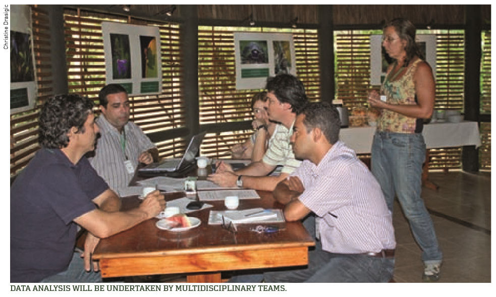
The GT contributes in the discussions and methodology calibration, but for the execution of these map projects a consultant was needed, considering the size of the effort, since the area to be mapped is the Atlantic forest boundaries, approximately 1.3 million square kilometers. Some maps have been concluded and others are under implementation phase. They are: potential areas for forest restoration, areas with high connectivity and resilience, map of potential areas for payment programs to environmental services related to water, eligible areas for forest carbon projects. (according criteria of Kyoto and Voluntary Market)
Please describe how you work in your local conservation and GIS community: Instituto BioAtlântica (IBio) has promoted communication and information exchange among government, several non-government organizations, universities, local communities and private sector for biodiversity conservation through our initiatives.
Several NGOs work in partnership with us (Instituto Terra, Conservation International – Brazil, The Nature Conservation - Brazil) in several areas and the exchange of information with them is of great importance. Our work involve environmental analysis for nature conservation in the Atlantic forest and in each initiative, we are always committed to articulate the strategies and the planning with different types of stakeholders, from local leaders and community associations until environmental agencies, municipalities and institutions that support rural entrepreneurship.
As such, to obtain good results, it is fundamental to keep strong exchange among different organizations that act more directly with these communities (Natureza Bela, Instituto Cidade, Associação Mico Leão Dourado, Organização para Conservação de Terras, among others) always considering local communities specificities and distribution in order to couple sustainable development and environmental conservation.
As Ibio has as its premise the incentive to participatory planning of the projects in local and regional scale, we often promote workshops allowing the meeting of the stakeholders and the discussion through thematic groups that are formed by individuals from different institutions and visions. Some workshops that we promoted:
- Workshop "Planning for Muriqui Ecological Corridor" Participatory formulation, by all stakeholders involved, of proposals for environmental conservation and income generation through sustainable productive chains, aiming to guarantee the supply of environmental services as clean water, recreation and ecotourism. Rio de janeiro, 2010.
- Workshop "Strategic Planning of the Central Fluminense. Mosaic". Participative development of the planning providing the financial sustainability of the mosaic of conservation units, definition concerning zoning, schedule and priorization of actions. Teresópolis, 2010.
- First round of forums Integrated Management of the Territory in the Complex Port of Acu, RJ. Participative planning from proposals of local leaders to soothe the interventions in the territory. Development o diagnosis, construction of future sceneries by prospective and human capital formation. Rio de Janeiro, 2011.
We also have partnerships with some institutions of research, in order to obtain wider knowledge and exchange of information, mainly relation on applied research and new technologies. We have a close collaboration with the Laboratory of Landscape Ecology of the University of São Paulo which has allowed us to explore concepts of functional connectivity of the landscape in some of our performance areas, as in the Atlantic Forest Central Corridor - study published recently in the magazine Nature and Conservation (http://www.abeco.org.br/publicacoes/natureza-e-conservacao/volume-9-numero-2/research-letters/anchor...). We have a partnership with the Center of Primatology of Rio de Janeiro in actions that we executed in the Ecological Muriqui Corridor, biodiversity corridor that we have established together with the state environmental agency in the north portion of the state of Rio de Janeiro. We are outlining the strategies for a study program in conservation biology and proposals of action to the populations of Muriqui do Sul. (brachyteles arachnoides), the largest primate of the Americas that is at risk of extinction.
Besides, we always try to closely follow the dissertations results and doctoral theses carried out in our areas of expertise and often we established frequent contact with these students.
Please describe how your work involves cooperation with any international groups: IBio’s work involves cooperation with several international groups that are mainly interested in increasing knowledge and improving biodiversity conservation at Atlantic Forest. Non- profit conservation organizations such as Conservation International and The Nature Conservation have promoted research and conservation projects with partnership with IBio. Our close work with these organizations allows us to exchange information and access databases that are fundamental for a better understanding Atlantic Forest biodiversity, your challenges and opportunities.
One of the projects in which we act in partnership with Conservation International and The Nature Conservancy seeks the unification of conservation strategies and the establishment of common protocols (biodiversity monitoring, forest restoration and creation of protected areas) for three forestry companies that operate in the same territory, the Central Corridor of the Atlantic Forest. Recognized as a biodiversity corridor and a region that has high biodiversity and large number of endemic and threatened by extinction species, comprises the state of Espirito Santo and the southern of Bahia state. The summary of this project is described in the next session and I intend to submit it to the Conference.
Other projects we are developing in partnership with these organizations, approach initiatives to forest restoration with potential of carbon credits, programs of payments for environmental services in some regions of the atlantic forest, mainly in the states of Bahia, Minas Gerais and Espirito Santo.
In addition to the international organizations mentioned, we work with some international companies for which we offer support of environmental planning and the development of proposals for action in the region of new enterpreunership or in some other region of your interest, such as: Kimberly Clark, DuPont e Anglo American.
We had already obtained support for the realization of projects through the resource of the United States Agency for International Development (USAID).
One of the great challenges of my work is to keep balance between economic interests and conservation issues, between surveillance capabilities and actual activities. In Atlantic Forest conservation is claimed to be an important factor of public politics, developing techniques and routines of use of advanced tools for spatial data analyses towards either conservation or sustainable exploration is a fundamental step to guarantee that environmental law is fully executed.
It is a great challenge nowadays to identify (both quantitative and qualitatively) present human pressures and alterations before they turn into serious threats to ecosystems, causing irreversible damages to the biodiversity at several areas in atlantic forest. Besides, many professionals (including myself) in IBio are still mainly incapable of applying more accurate techniques of image analysis and geoprocessing tools. GIS capacity building would greatly increase our ability to map the opportunities for working with payment for environmental services in several rural areas offering more accurate data for governmental and non-governmental conservation organizations to promote these programs.
Furthermore, the dynamics in the emergence of new technologies have become another very special challenge. Personally, I'm always searching the internet, attending courses, conferences and workshops and exchanging experiences with other users to keep ahead in this field.
2012 Scholar Conference Presentation:
“Sustainable Forest Mosaics: Integrated planning and establishment of common protocols for biodiversity conservation and forest restoration”
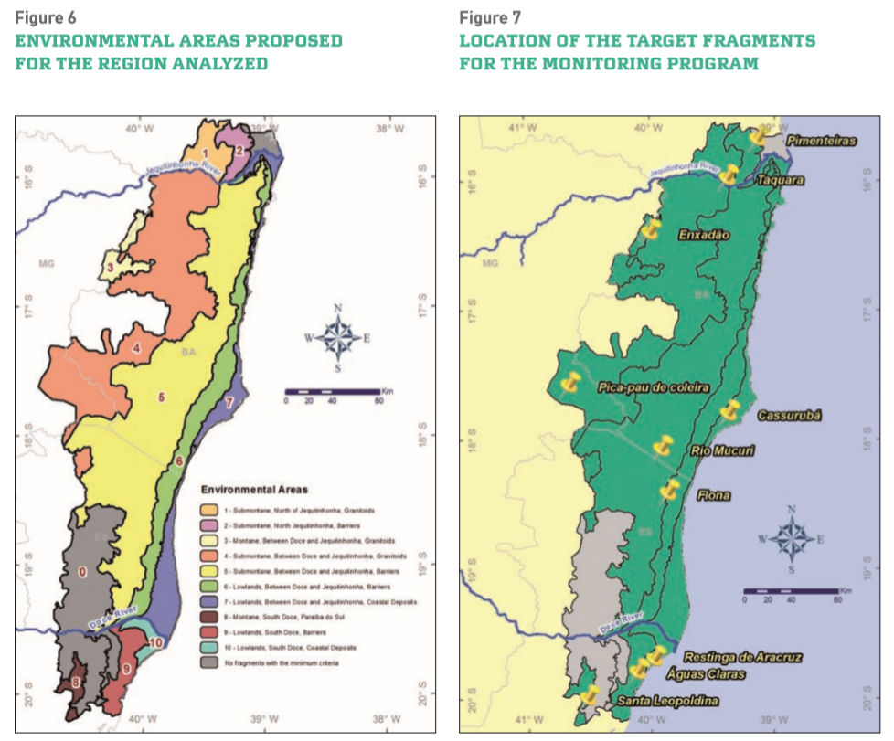
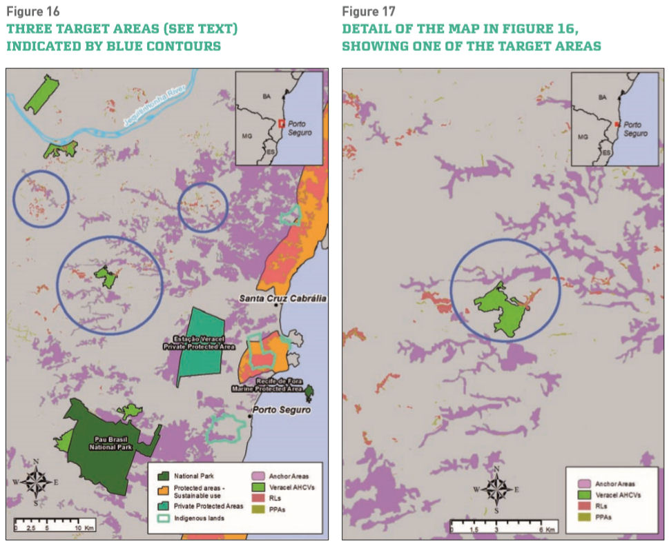
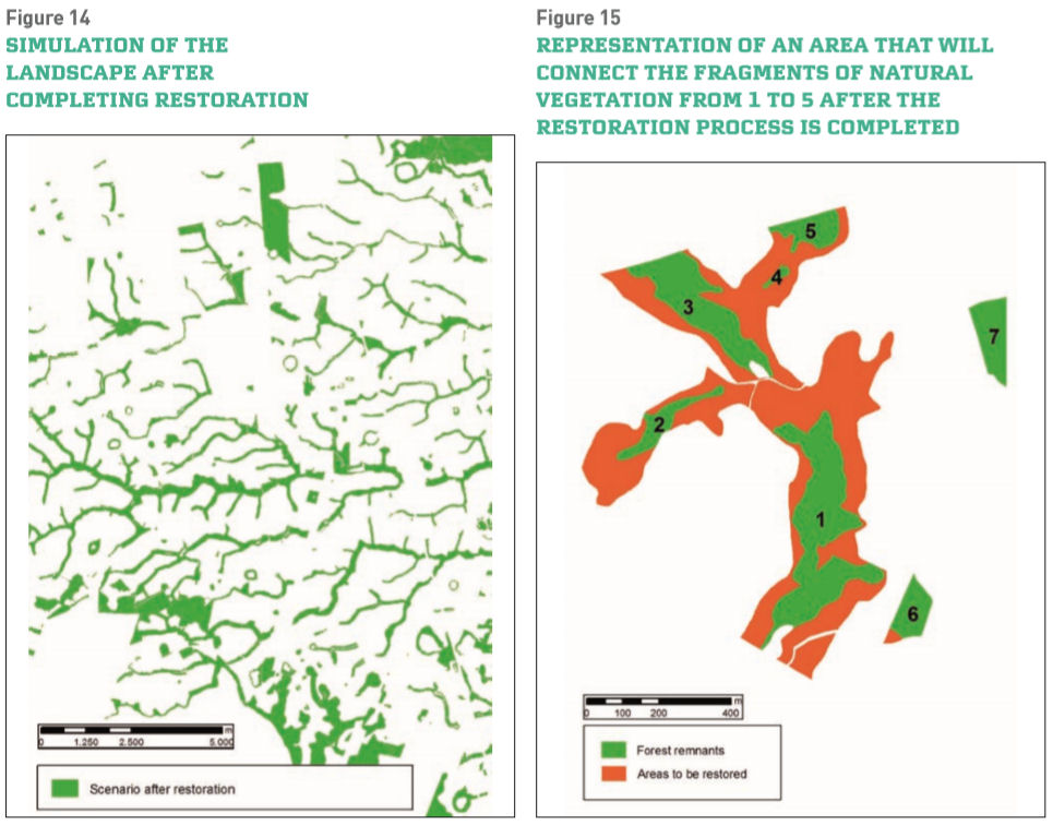
The sustainable forest mosaics (SFM) concept recognizes the multiple roles tropical forests serve around the world. Tropical forests are critical for the global climate, helping mitigate climate change by absorbing and storing CO2 while generating oxygen. They protect watersheds, prevent erosion and soil degradation, cycle water and nutrients, supply nontimber forest products, and serve as habitat for the majority of the world’s known species. Tropical forest areas are also home to substantial forest plantations, which supply an ever-growing portion of the world’s demand for paper, personal goods, and inexpensive wood products. The SMF concept views forests as a “puzzle” of different land uses, working at a landscape scale to plan productive activities while protecting the forest ecosystems and the services they provide. The Sustainable Forest Mosaics Initiative has the goal of increasing the effectiveness of conservation and biodiversity efforts in the forest mosaics that combine remaining native and planted forests. This unique Initiative encompasses three different scales, local, regional, and global. This design builds on ongoing work in one region of Brazil while seeking to expand this successful model to the rest of the Atlantic Forest and other regions of the world where plantation forests have a large footprint in landscapes. The Initiative takes a science-based landscape approach, seeking to guarantee results in an area large enough to benefit a range of species and ecosystems. The Forest Mosaics initiative was launched in 2007 by KimberlyClark, Conservation International, The Nature Conservancy and the Instituto BioAtlântica. Three leading pulp and paper companies soon joined the effort (Veracel Celulose, Aracruz Celulose, and Suzano Papel e Celulose), and several additional partners have since formally joined the Initiative and are working to achieve common objectives. A huge work was developed using GIS tools to assist in this challenge, first to define the places where the monitoring stations must be chosen and to set a timeline for areas prioritizing to restore at the regions that companies operate. A clear and unbiased view of biodiversity changes in the region covered by the monitoring stations was possible by choosing monitoring stations at locations that represent all the types of vegetation and topographies in the region. Also relevant was the establishment of stations along similar types of vegetation and topographies on opposite sides of the geographic barriers existing at the area. The restoration actions will be concentrated in carefully chosen locations, where a positive impact, as large as possible, is expected to restore the connections needed to maintain the gene flow and to promote biodiversity maintenance. Thereby, the prioritization strategies were delineated in the sense of enabling to choose the locations where the restoration and conservation actions will have the greatest positive impact on the landscape and biodiversity structure. In order to define a methodology to define the anchor areas for conservation and restoration, it considered the fact that it is very important to optimize the use of available resources–that will always be limited–in order to generate the greatest possible benefits to the natural ecosystems. This methodology proposes more refined criteria for prioritizing restoration actions in Permanent Preservation Areas (PPA), Legal Reserves (LR) and other types of areas and the criteria to prioritize the areas to restore were established, so that the actions are initiated by the areas that will connect more vegetation fragments when the restoration is complete and so that the greatest restoration benefits are achieved in the first phases of the projects.
x2012Scholar x2012Talk xScholar xTalk xEcology xBrazil xLatinAmerica xWomen xLatinx xLandscape xEcosystemServices xSustainableDevelopment xWatershed xPlan
-
 Anonymous User