- Home
- :
- All Communities
- :
- User Groups
- :
- Conservation GIS
- :
- Documents
- :
- Nelson Mwangi, Kenya
- Subscribe to RSS Feed
- Mark as New
- Mark as Read
- Bookmark
- Subscribe
- Printer Friendly Page
Nelson Mwangi, Kenya
Nelson Mwangi, Kenya
Navigation: 2018 Scholar Project ReferenceProject CommunitiesPage ConservationGIS Scgis.org
Nelson “Nellie” Mwangi, Research Assistant, GIS and Animal Tracking, Save the Elephants (STE), KENYA
 <-pdf 2018 SCGIS Presentation mp4->
“Using GIS to control and map invasive cactus along the Ewaso Nyiro River, Laikipia-Samburu Ecosystems, Kenya.” "In Kenya the spread of opuntia has increased, encroaching into over 500km2 of protected areas including Laikipia and Tsavo East National Park and surrounds. ...Elephants and baboons also eat the fruits of the prickly pear helping in their dispersal. It is therefore necessary to control this invasive species to stop dispersal and also minimize animal deaths from ingestion of the glochids/spines.
 <- 2018 Nelson Introduction
 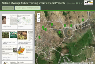 on his work with “Save the Elephants radiotracking & analyzing elephant movements
2018 Scholars Storymap -->
on the impact of Invasive Opuntia Cactus plants in Kenya and their control to help ensure a safe habitat for Elephants. (NOTE, this is a 2-tab storymap with one a left tab acessing Nelson's work creating a storymap about all of the other scholars, and a right tab accessing his SCGIS Conference presentation material on Opuntia vs. Elephants in storymap form)
Nelson “Nellie” Mwangi,
Research Assistant, GIS and Animal Tracking, Save the Elephants (STE), KENYA
Save the Elephants, Marula Manor, Marula Lane, Karen, Nairobi, Kenya
P.O. Box 54667, Nairobi – 00200, Kenya
*-Main email: [email protected] website www.savetheelephants.org
Skype etc:[email protected] (Google Hangout and Skype) [email protected]
GIS is an expanding and changing field with new technologies, tools and applications being invented constantly. One can never be content with the GIS skills they have and this necessitates the need for more education, more interactions with other GIS users and continued practice and application of GIS in solving real world issues. In Kenya, GIS is a relatively young field with many people not being familiar with the power and potential that GIS has in tackling real life daily issues. But, by teaching and involving more people in GIS training, awareness and making GIS interesting the trend has started to change. People are taking part time classes and online courses and applying GIS irrespective of their education background. ESRI has been on the forefront in this, visiting schools and hosting GIS workshops in Kenya and around Africa. I happen to be part of this group of young Kenyans who have shown a keen interest in using GIS in conservation and wildlife management and I cannot begin to explain how useful GIS has been as a conservation tool. Therefore, this opportunity is the best thing that any GIS user can ever have for interacting with different cultures, professions and leaders in the GIS world. Other than applying to learn new skills, my other great reason for applying is to interact with these people and learn what they have to offer and vice versa. In conclusion, I would greatly appreciate the opportunity to be able to participate and contribute to the SCGIS community, this scholarship and any future SCGIS interactions.
Save the Elephants is a Kenyan based NGO founded in 1998 with a mission to secure a future for elephants and to sustain the beauty and ecological integrity of the places they live; to promote man’s delight in their intelligence and the diversity of their world, and to develop a tolerant relationship between human beings and wildlife. With this in mind Save the Elephants has expanded from Samburu to other regions in Africa focusing on radio-tracking elephants and community conservation. STE has so far conducted numerous and comprehensive studies of elephants, including elephant collaring and more recently, sophisticated elephant tracking techniques. To ensure conservation of elephants and their natural habitats STE has done studies on elephant movements, ecology and behavior, and through community and education programs and also by looking at conservation from an elephant’s point of view which is ensured through various projects as outlined:
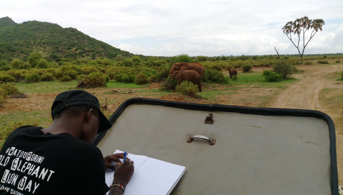
Long term monitoring of elephants (LTM). The Samburu elephant population is one of the best studied in the world. STE researchers collect LTM data daily. The elephants using Samburu and Buffalo Springs Reserves are habituated to our researchers and vehicles, enabling easy observation of behavior. Understanding these individual behaviors is important in devising ways and means of securing a future for elephants and promoting coexistence with human beings. This combined with parallel radio-tracking study allows STE to understand how elephants make choices, by studying their movements. This leads to the definition of vital corridors and dispersal areas outside protected areas. STE’s Elephant Crisis Fund is used to fund the best-conceived interventions in the most critical hotspots to stop the killing, stop the trafficking, and to stop the demand for ivory. The fund has helped train more community rangers across Africa, increased the number of collars deployed and also funded aerial patrols and quick response teams to incidents out in the field. (See attached pictures 1 and 2: collecting LTM data in Samburu National Reserve).
Human-wildlife conflict mitigation. By use of geo-fences and community beehive fences (Elephants and Bees Project with an 85% success rate) STE has managed to increase the peaceful co-existence between elephants and human beings.
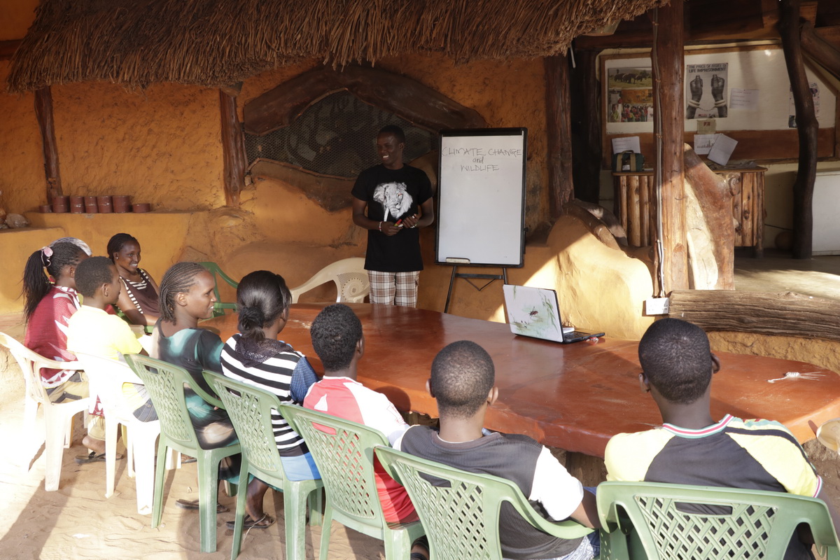
(photo: Teaching high school students during one of STE’s education sessions) Education. STE’s education program includes scholarships, conservation education, internships and infrastructure development. The program targets primary school minds exciting the children about elephants and their environment through films, games and school trips. After that STE also offers local and international scholarships internships in which interns study elephants, learn data entry and statistics after which they learn to plan lessons and teach at local schools, passing their knowledge to other students.
Local Community Work: On my 3rd year in university I was a part time statistics and GIS tutor to 1st and 2nd years. I was also leader of the environment club which involved going to school and giving talks on waste management, sustainable living and also participating in clean-ups in the various slums in Nairobi. While on internship with Elephants and Bees and STE interns are required to hold weekly lessons with primary and secondary school kids teaching topics of their interest such as ecology, tracking animals and conservation education. I was involved in these programs with sustainability and wildlife conservation as my focus topics. After I joined STE as a staff member I have taken an active role in mentoring interns in various GIS and monitoring projects. My role includes tutoring interns with no GIS background, helping them produce basic to advanced maps from existing data or data they have learnt to collect from the field using GPS units and ArcCollector. Upon completion of their internships they are supposed to produce reports with corresponding maps which are filed for reference by incoming interns. Recently I was involved in training local Samburu women how to collect wildlife field data using Garmin GPS units for the Corridor Matriarchs project mentioned earlier. At STE we also have field trips for Primary and Secondary school children teaching them how to appreciate wildlife, to conserve their environment and the relationships between elephants and the ecostsyem.
I have also taken part in a number of walks both in Samburu and Nairobi to promote the message of elephant poaching and its effect in the elephant families that we monitor. The walks include the Elephant and Rhino walks, Say No Ivory walks and End Poaching Now!
At STE I am responsible for compiling aerial patrols reports and producing Google Earth and ArcGIS online maps of the airplane tracks and elephant locations from these patrols collected using ArcGIS Collector and Garmin GPS devices. Aerial patrols are held once or twice a month or when something urgent happens and we have to fly to a remote area. From these we get positions of elephants and our airplane tracks and we can produce reports of our recce’s and how many animals were seen and also whether there were any livestock herds around and how close elephants are to anthropogenic factors.
Spatial database management and maintenance. Save the Elephants collects a diverse range of spatial data from all over Africa and we have a rich database of spatial features we have collected or digitized including Human-footprint data, cartographic features and elephant tracks covering a very long period of time. My role in this includes collecting and ingesting more data into the database, using ArcMap to clean this data and receiving data from our partners across Africa. I also assist in providing data that our partners might be lacking and performing analysis and everyday use maps from this data.
One of my main tasks includes using the Save the Elephants Vulcan-Powered app to track over 300 collared elephants across Africa and reporting interesting, strange or suspicious behaviors from our tagged elephants, responding to red alerts and alerts from crop raiding elephants. From the collars we can get various kinds of information such as by the hour location of the elephants, speed and acceleration, and also when an elephant has stopped moving or is getting into a farm. I also map these movements and sometime make animations about interesting behavior using Doarama such as this case of a collared elephant stuck on one side of a National Park fence: http://doarama.com/view/1715863. Another interesting movement is shown below using data from a tagged elephant.
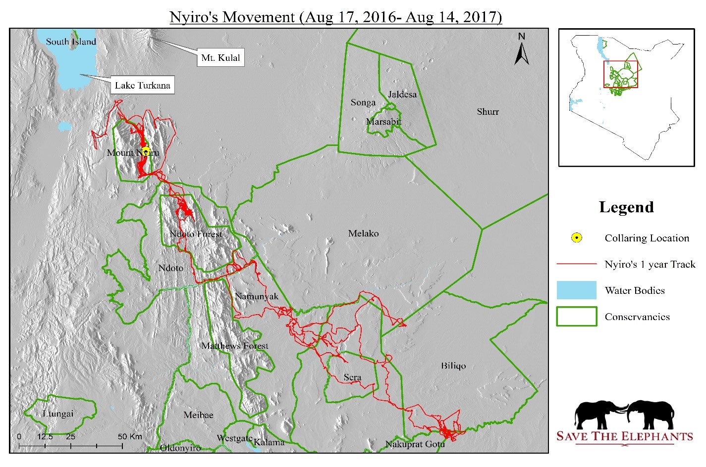
Figure 2: Tracking Nyiro, a collared elephant who moved into an area where elephants were last seen 30 years ago.
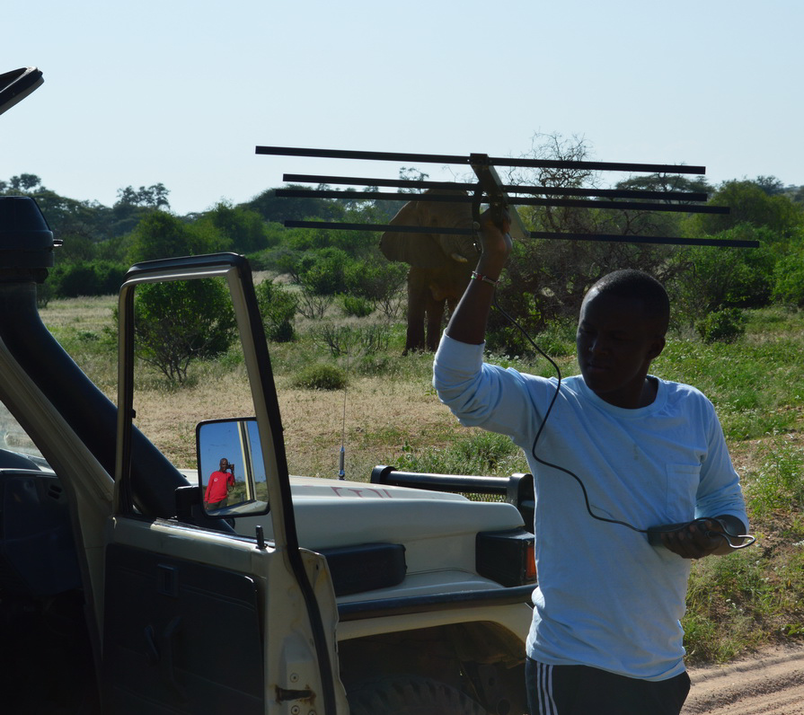
Coordinating with rangers on the ground. From our tracking system we can see the locations of elephants in relation to ranger vehicles and ranger posts. I also communicate with these ground teams in cases where an elephant has been injured, killed or has dropped its collar. This helps in quick response and we have managed to rescue elephants, treat injured elephants and also retrieve dropped collars in a very timely manner (See attached picture 3; listening for VHF signals from a dropped collar with STE’s head ranger)
Control and mapping of invasive species. I recently initiated a project to control an invasive species, the prickly pear (Opuntia ficus indica and Opuntia stricta) which has caused a lot of ecological damage and also killed a lot of livestock and a few elephant calves when they eat the plant. See proposed paper for more.
I also design data collection formats for most of our projects in ArcCollector and this has greatly reduced our reliance on paper and the time required to clean, analyze and present field data. From the Collector, I have also integrated ArcGIS for excel in most of our computers and this has provided a very fast way to and analyze data collected even by people with little or no GIS knowledge.

Figure 3: Analysis and presentation of mammal census data from the Collector using ArcGIS-Excel plugin
I also got a lead role in a citizen science project called the Corridor Matriarchs which involves employing local women who are responsible for looking after elephant corridors making sure they are free of any development and also counting the animals that are using these corridors using footprints and dung/scat. At the moment my role includes training these women how to identify various animal tracks, how to record GPS coordinates and how to store the data. I will later collect this data for future analysis of these corridors.
*-HISTORY: I got interested in GIS and remote sensing when I started my undergraduate studies in Environmental Resource management at the Technical University of Kenya. From the first GIS class I knew this was the path I wanted to take. I majored in Wildlife management and applied GIS to interpret phenomena in the ecosystem. I started off working with Save the Elephants (STE) as an intern in 2015 when I applied for an internship with the Elephants and Bees Project at the Kenyan Coast. While there I did my undergraduate research titled ‘Effectiveness of using Indigenous Knowledge in mitigating human-wildlife conflicts’ relying on ArcGIS and SPSS for most of my data analysis. While there, I observed a lot of things such as human - wildlife conflicts, impacts of infrastructure on the natural ecosystem and most of all habitat loss, this further sparked my interest in landscape ecology and remote sensing.
However, after my studies at the end of 2015, I realized my GIS skills were not up to par with the Kenyan GIS market and conservation world. So I took it upon myself to take online classes and also attended a 4-weeks GIS course in a private college in Nairobi. With this I rejoined STE for a 5-month second internship in August 2016 helping with various projects including daily mammal census, long term monitoring of elephants and digitizing the human footprint in the Northern part of Kenya. As an intern I did various projects including musth bulls and livestock numbers-NDVI analyses using ArcGIS, Excel and R.
Local SCGIS work: I met a former SCGIS scholar when we both interns at STE in 2016 and we remained in contact even after we went our different ways. We have since been sharing GIS contacts, helping each other solve GIS and ecological problems. One of my colleagues, Festus Ihwagi is also an official of the Kenyan SGIS Chapter and he has helped me advance my GIS since I joined Save the Elephants. I hope to join and contribute to the local SCGIS chapter as soon as possible and hopefully become an SCGIS volunteer after the scholarship.
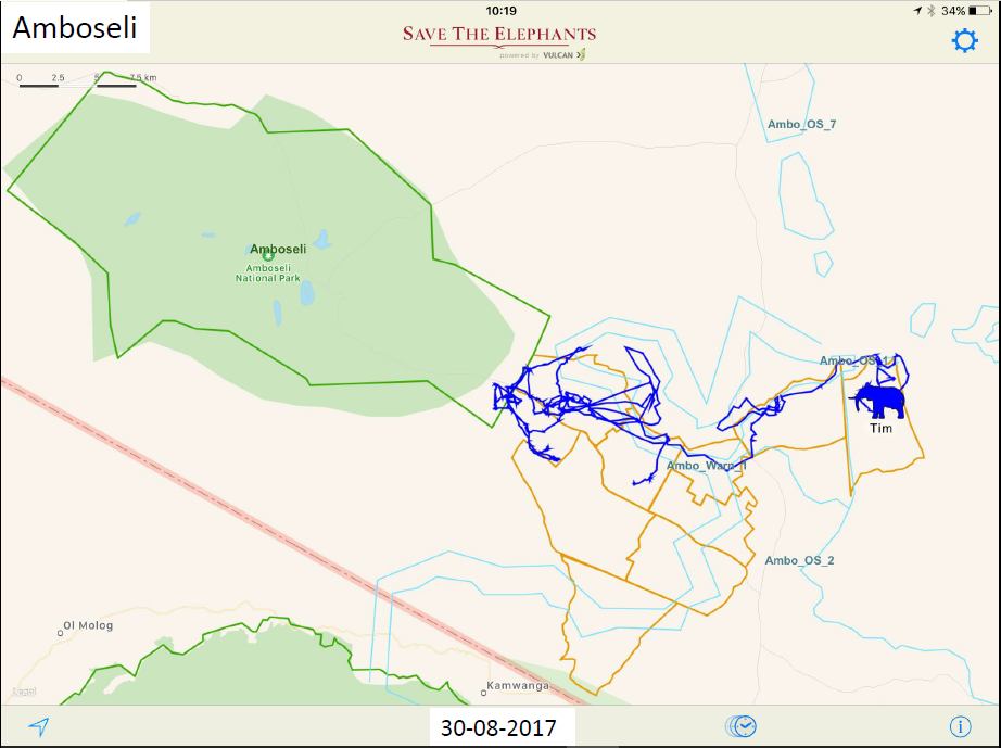
Figure 4: Tracking a crop raiding elephant using Geo-fences (light blue polygons). Blue lines represent the elephant’s 16-day movement.
What is most unique about your work? My work is unique in that we are using new, improving and cutting edge technologies (Save the Elephants Vulcan-Powered tracking app) to track elephants in real time and be able to respond to emergencies such as Human-wildlife conflicts and poaching incidents over a large geographical area (Africa and some parts of Asia). I am also able to tell interesting stories using our tracking system and by use of maps and animations which has helped create awareness and portray elephants as interesting animals in the Social Media platforms. Another unique aspect of my work is that we work with the local people recruiting them for our citizen science programs, empowering women and supporting rangers by providing real time elephant data and helping them respond to incidents on time. Poaching, death of rangers and loss of elephants to other factors is one of the greatest challenges to me personally and emotionally and also a challenge to my organization. Access to GIS workshops and training is also a challenge which has left me to heavily rely on online resources to expand my GIS knowledge and skills.
Plan for the next year: With all the skills I will acquire from this scholarship I hope to achieve the following targets:
The first thing I intend to do over the first few months after the scholarship is to pass on the things learned to other people. This will start with my colleagues in the GIS department and then with my capacity as interns’ supervisor I will pass on this knowledge to more interns. This will not only happen for 1-year but will be an ongoing task with every new group of interns we get.
I also intend to change how we collect data in the field including our daily monitoring of elephants around our core study areas including Samburu National Park, Buffalo Springs National Reserve and Shaba National Reserve using mobile data collecting application like Survey 123 and Collector for ArcGIS. This will effectively improve how we update our elephant database and mammal census database in that it’s all stored in our geo-database.
I also intend to start a land-use and vegetation study project which will cover the next 6-months after the scholarship. With the things learned from the scholarship I hope to produce better output than before. After the vegetation map is ready I will be able to compare vegetation from year to year, measure the level of vegetation loss and deforestation. Combined with STE’s Human-Footprint data (2001-2014 and 2014-2017) this land use data will be helpful in assessing the level of encroachment into protected areas, loss of habitat and how this has influenced the migration patterns of elephants and other animals.
Using the Spatial analysis and other GIS analyses knowledge learned from the scholarship I plan to be able to produce and predict paths/corridors using ArcGIS and later on compare the predicted corridors with corridors defined from collared elephant movements. This will take a short time (1-2 months) and it will help produce a clearer picture of the corridors and also aid in ensuring the corridors are protected from any human development. With ArcPy and ModelBuilder training from the program I plan to produce various workflows and python scripts for different STE projects. This will not only save time but will ensure uniformity in the type of output produced by different personnel in STE.
STE’s Collar tracking data not only involves location data but also human-wildlife conflicts and crop-raiding data by using geo-fences. This data has not yet been analyzed and I hope to gain adequate skills from the program to help in analyzing, map and hopefully predict crop raiding incidents across Africa.
I have always been interested in waste management and sustainable development and renewable energy use and I hope to apply all the GIS skills learned to solve these issues. This can be in the form of proper planning, helping in Environmental Impact Assessment, planning for waste disposal sites and green living awareness projects.
The program is also a great stepping stone for my future postgraduate studies. My long term plan is to enroll for a GIS master’s and this program will not only increase my chances for getting a GIS master’s scholarship but will also equip me with priceless GIS skills in preparation for this further education.
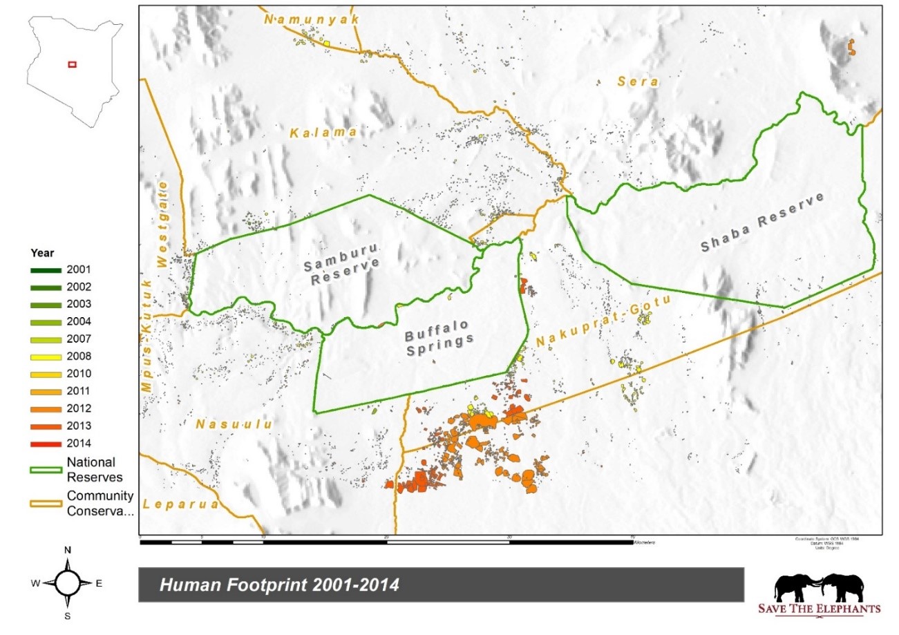
Figure 1: a preliminary view of human-footprint data digitized on Google Earth using aerial imagery (Map produced by Nelson Mwangi using ArcMap). Study area is Samburu (Coordinates: 1010’N 360N40’E), Northern Kenya.
GIS Work: Other than college education I have mostly learned a lot of GIS through self-taught and free online classes from sites like edX and Coursera. Also through GIS training and workshops within my organization taught by experienced researchers such STE’s Geospatial Science Advisor Dr. Jake Wall and Head GIS analyst Festus Ihwagi.
I have acquired adequate skills in GIS to move to the next level which moving on to ArcPro; in depth spatial analysis and the ability to show the relationship between wildlife and the landscape using various GIS analysis tools and workflows. I am also very keen to advance my remote sensing skills as this will help in landscape modelling and the ability to predict phenomena in the ecosystem using R and ArcGIS. I have encountered problems using ArcPy and ArcScene and I am really keen to learn about these two aspects of GIS. I have been able to take care of various databases but I am really interested in learning how to create databases and manage them for various personal and organizational projects. I have encountered problems with symbology and colors when producing final maps and I would like to understand the various needs of people such as color blindness, font preferences and styles to use various for maps meant for diverse purposes and different groups. I am also very interested in learning how to use mobile apps in collecting data in the field including Survey 123 and Collector for ArcGIS. With this I will able to revolutionize how we collect data in the field contrary to the pen and paper that we use now in our field work. I have been learning this on my own and have included an example screenshot. I am also very keen on learning how to use Story Maps as I am a passionate wildlife and conservation blogger. Using Story Maps I think I will be able to engage my audience more and bring them closer to where my work revolves around using interactive maps. I am also very keen to learn more about ArcGIS Pro and how to integrate it with ArcGIS online having been self-taught in this. We have been using ArcMap for a while and I would very much like to migrate our work into ArcGIS Pro and ArcGIS online.
2018 Conference Paper Title: “Using GIS to control and map invasive cactus along the Ewaso Nyiro River, Laikipia-Samburu Ecosystems, Kenya.”
"Opuntia stricta and Opuntia ficus indica also known as prickly pear are invasive cacti in Africa. In Kenya the spread of opuntia has increased, encroaching into over 500km2 of protected areas including Laikipia and Tsavo East National Park and surrounds. Livestock and wildlife have long been affected by the invasive cacti in the Laikipia-Samburu ecosystem with herders complaining about the plant killing their livestock especially during the dry seasons when they run out of grazing options. Elephants and baboons also eat the fruits of the prickly pear helping in their dispersal. It is therefore necessary to control this invasive species to stop dispersal and also minimize animal deaths from ingestion of the glochids/spines. This can be done mechanically or by use of the sap-sucking cochineal bug which is host-specific and the bug Dactylopius opuntiae is specific to O.stricta (stricta biotype) (Klein, 2002). The project objectives are to:
- stop the spread of opuntia by using mechanical and biological controls
- map the distribution of opuntia in Laikipia-Samburu
- create a database for the various species of opuntia
Preliminary field studies of the distribution of opuntia were conducted on 2nd-4th November 2017. Location data of the species along Ewaso Nyiro River was collected using Garmin GPS units and mapped using ArcMap and QGIS. Most of these sightings were rooting cladodes/leaf pads and a few mature plants, there were also sightings of rotting cladodes and one instance of a plant infested with the biological control agent. Dominant species observed was O.stricta with few O.ficus indica and thorn cactus sightings"
xInvasive xSpecies xVegetation xElephant xTracking xPark x2018Scholar x2018Talk xScholar xTalk xKenya xPOC xAfrica
Hello Nelson Mwangi,
Although decidedly slow, I found your post really exciting, especially for the details, and enjoyed following along.
I'm preparing to attend an ESRI MOOC - ‘Make an Impact with Modern Geo Apps’ in April, hoping to collaborate with Kenyan and US students to improve data availability to speed up SDG success stories in your country, especially rural areas like Bomet County. I hope we can collaborate going forward.
William Tarpai - Riverside, California US