- Home
- :
- All Communities
- :
- User Groups
- :
- Conservation GIS
- :
- Documents
- :
- Francoise Cabada Blanco, Venezuela
- Subscribe to RSS Feed
- Mark as New
- Mark as Read
- Bookmark
- Subscribe
- Printer Friendly Page
Francoise Cabada Blanco, Venezuela
Francoise Cabada Blanco, Venezuela
Navigation: 2016 Scholar Project 2016Conference ReferenceProject CommunitiesPage ConservationGIS Scgis.org
Francoise Cabada Blanco
Laboratorio de Conservación Marino-Costera, Departamento de Estudios Ambientales, Universidad Simón Bolívar, Venezuela.
Presentation -pdf (none )
2016 Scgis Conference Video -mp4 
*-Organization name: Laboratorio de Conservación Marino-Costera, Departamento de Estudios Ambientales, Universidad Simón Bolívar
Laboratorio de Conservación Marino-Costera, Pabellón 4, ofic. 4-013, Universidad Simón Bolívar, Carretera El Placer-Hoyo de la Puerta, , Valle de Sartenejas, Estado Miranda, Gran Caracas, Venezuela.
*-Main email:[email protected] Current Email:
My name is Francoise Cabada and I work in marine conservation. I have a master degree in biological sciences and I am currently finishing my doctorate at Universidad Simón Bolívar, Venezuela, where I also work as a junior lecturer, recently establishing the Coastal-Marine Conservation Lab. I started working directly in conservation in 2009, when I was hired by a NGO to coordinate a project on capacity building for indigenous communities. My formal training in conservation started with a Fellowship I was awarded by the ZSL´s EDGE of existence programme in 2013.
As part of this fellowship I received a grant to run a conservation project focused on a threatened Caribbean coral species in the most important coral reef marine protected area (MPA) of the country. Within this project, I started using GIS to map my conservation object´s distribution, as well as its habitat, threats and other resources use patterns, from data collected on the field through ecological and socio-economic surveys. The spatial analyses I have performed are basic and limited to vector layers; developing most of the skills used in these analyses through self-teaching and many hours of trial and error. However limited, these basic skills have been useful to answer relevant conservation questions, like the exposure risk to local threats of the species habitats and their complementarity and representativeness within the MPA zoning; proving the lack of compliance from key stakeholders. This is what I would like to present in the conference.
Please describe the work that your current organization does: My organization belongs to a public national university, located at the capital city of the country. The laboratory of Coastal-Marine Conservation, was recently established by myself (April, 2015) when I was hired as a junior lecturer. The lab´s work team vision is to ensure the delivery of the country´s coastal marine-ecosystem goods and services for future generations through the maintenance of their function and the sustainable use of their resources. Our mission is to provide decision makers at all levels with timely and pertinent scientific-based information for the management and conservation of coastal-marine biodiversity through interdisciplinary research and collaborative efforts.
For the past ten months the lab have been involved in various projects derived from my thesis and fellowship project. Specifically, a socio-ecological baseline for the conservation and management of the threaten pillar coral Dendrogyra cylindrus at Los Roques Archipelago National Park (LRANP). This project included a socio-economic and an ecologic survey to establish the population status of the species, its distribution health status, habitat characterization and distribution, identification of local threats, assessing the species and its habitat use patterns and local knowledge as well as estimating the dependence of stakeholders to the ecosystem services provided by the MPA coral reefs and assessing livelihood vulnerability to their degradation. This involved the use of an interdisciplinary approach by applying methodologies from various fields such as conservation biology, experimental ecology, social sciences, seascape ecology and environmental economics. Within the project we are now preparing an action plan for the conservation of this species, as well as the threatened Caribbean acroporids in LRANP, based on an experts workshop carried out in November 2015. Also, we have performed CEPA (Communication, Education and Public Awareness) activities with local lodges and fishermen associations.
From the budget granted to the project by ZSL´s EDGE fellowship programme, we were able to include the threatened Caribbean acroporid species in the sampling design to assessed its distribution and health status, providing a student with her bachelor´s research thesis focused on Acropora cervicornis. Working with the Mecatronica (mechanic-electronic engeneering) research group of the university, we are collaborating in developing a low-cost sampling method using video-transepts and 3D models for structural complexity estimations. This also provided a master student with his research thesis.
As the lab was established less than a year ago, it does not have formal international collaboration agreements, but my aim in the short term is to work in collaboration with other Caribbean research institutions and NGOs. The lab is currently informally involved with IUCN´s WCMC Connectivity Conservation database project, by building a database on marine connectivity conservation initiatives for Latin America and the Caribbean with the Landscape Ecology and Conservation Lab of the university. Also, I am receiving support from Professor Richard Preziosi at Manchester University, as I will perform the genetic analysis of Dendrogyra cylindrus samples for population genetics at his lab.
Please describe your personal role in the organization: Although the Coastal-Marine Conservation lab was recently established, I worked at my advisor´s lab as a research assistant for two years (2011-2013), which is in the same university. During this period, I worked in several environmental impact assessments for exploration and extraction projects of national and international oil companies and a citizen’s science rocky shore monitoring program. During this time I wrote several grant applications, two of which were granted by national organizations to strengthen the lab´s capacity. I wrote the lab´s annual report, was in charge of field logistics, equipment’s maintenance, biological oceanography sample analyses and projects data analysis and technical report writing.
When I successfully applied for the EDGE fellowship, I decided to start my doctorate at the university. The fellowship included a 10.000 sterling pound grant for a species-focused conservation project. So, from 2013 until present my main role has been as the project´s PI. I have designed the field surveys (both socio-economic assessment and ecological survey), process the sampling permits, planned field logistics, managed the budget, established relationships with national and local authorities, other national and community organizations and stakeholders, analyzed data and wrote monthly and semi-annual reports, articles addressed at the general public and the first research papers derived from the project.
Two months after I was hired as a junior lecturer at the university, in April 2015, I was granted a laboratory and I funded the Coastal-Marine Conservation lab. I still perform the same role with the project, but I also participate in other collaborative research projects, and manage the lab´s operations. In the academic field, I teach two undergraduate courses: Sustainable use and conservation of marine resources and Community ecology. I am a co-advisor of a bachelor´s thesis and I have also been advisor for a bachelor´s seminar (students have to perform a review on a specific subject) and coordinated the evaluation committee of a master research thesis proposal.
Please describe the history of your personal work in conservation and GIS: I started my career working with coral microbiology. I was interested in understanding the interactions between the coral and its microscopic partners, what mechanisms triggered coral diseases and how this knowledge could be applied to prevent coral cover lost. When I finished my master I felt that I needed to contribute more directly to conservation, and so, I started working with an NGO (Ius Naturae) in a project to build capacity in Pemon (indigenous ethnic group) communities, located in the border between Venezuela and Brazil. The aim of the project was to shift these communities’ from illegal gold mining to more sustainable livelihoods like ecotourism. During this period I learned -the hard way- three important lessons: 1) how important the interdisciplinary approach is to achieve conservation success, specially the ones pertaining to the human dimension of conservation, 2) how scarce is important science-based conservation-relevant information in my country and 3) how immense is the gap between scientists and decision makers at all levels (from local communities to national governments). From this experience I decided to work in conservation, I found my true passion. After one year, the NGO was unable to find funds for the project. I was able to continue working with the communities for another six months, supporting myself as a trekking guide.
As the NGO closed all field projects, I was hired at the university and, while working as a research assistant I started drafting a project on conservation and management of the most important coral reef MPA of the country, Los Roques National Park. For one year, I applied to various grants to find funds for the project, until 2013, when I was successfully selected as an EDGE fellow. During my fellowship I participated in several courses on conservation within the fellowship capacity building program. I also enrolled in various post-graduate and online courses to improve my knowledge and develop skills I need to apply to the project. One of these courses was an introductory course in landscape ecology at the university. It was on this course where I started using GIS as a research tool with my data (not merely to compose maps of study sites!) and I realized how powerful it could be, not only to answer ecological and conservation relevant questions, but also to aid understanding and communicating spatially explicit patterns and processes.
Please describe what is the most unique and the most challenging about the conservation/GIS work that you do: My work has many exciting things, from the extremely beautiful sceneries in the field to the candid and valuable local people I have the privilege to interact with at my study site. However, the things that excites me the most are: being able to continually learn and apply different skills to design conservation strategies within the highly complex socio-economic and political scenario of my country, work with colleagues from different disciplines, and decipher the live traits of my current conservation object, one of the most poorly-known threatened coral species of the Caribbean, the pillar coral. Currently, the most difficult part of my work is trying to figure out a way to establish a monitoring program so that the work we have done for the past two years in establishing the socio-ecological baseline does not go to waste due to “the shifting baseline syndrome” from lack of monitoring and evaluation. The difficulty in achieving this is the lack of financial, equipment and human resources due to the specific economic and political situation of the country. This leads me to the obstacles in running my GIS project and the reason why I am applying to the SCGIS scholarship. Remote sensing is an excellent cost-effective alternative to in situ data collection for monitoring and management, at least at the scale of the whole MPA. Concomitantly, I have gathered enough data on the field to explore species distribution models and larval dispersion as well as to validate habitat characterization using image analysis. However I have had trouble finding in-country guidance on GIS analytic tools in marine environments, which has lengthened the pace in my “trial and error GIS self-taught method”.
The uniqueness of my work resides in the fact that I am one of the few researches in the country working in marine conservation applying an approach beyond marine biology and ecology and doing this in a truly collaborative framework with other research groups, experts and local organizations.
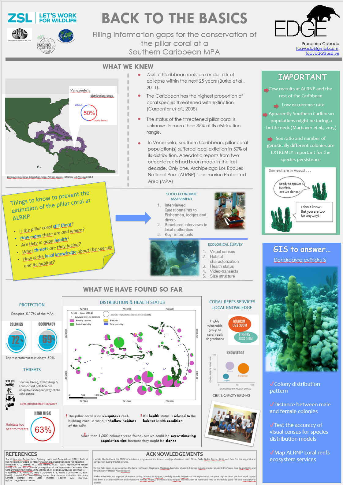
PAPER TITLE: Exposure of the threatened pillar coral´s habitat to local stressors at Los Roques National Park, South Caribbean: evidence of non-compliance.
2016 Abstract: (Session: "Marine Biodiversity") I evaluate the effectiveness of the current National Park use zoning to ensure the representativeness and protection of the pillar coral populations, and propose alternative spatial plans based on bio-ecological and socioeconomic data to ameliorate threats and increase coral reefs resilience. Spatial analyses between four information layers were performed. They included: 1) the National Park zoning, 2) species presence/absence and abundance 3) habitat characteristics and health status, and 4) a “threat-risk” index, developed from in-site bio-ecological data and current threats identified from questionnaires and interviews to key stakeholders. Sites with higher abundances of the pillar coral coincided with higher levels of protection among zones of the National Park. However, tourism-related stakeholders and fishermen don’t comply with the zonation. This reflects on the habitat health status and threat-risk index, highlighting the need of implementing new planning strategies under the real enforcement capacity of the Park´s authorities. These results are the first attempt to evaluate the “conservation effectiveness” of a MPA in Venezuela, focusing on coral reefs and threaten coral species, offering a baseline for more comprehensive planning strategies that include underwater habitats as priority ecosystems due to their prime importance for the maintenance of biodiversity.
xPark xMammal xFisheries xMarine xCoralReef X2016Scholar x2016Talk xTalk xScholar xWomen xLatinx xVenezuela xLatinAmerica
-
 Anonymous User