- Home
- :
- All Communities
- :
- User Groups
- :
- Conservation GIS
- :
- Documents
- :
- Fabrice Yengong Lamfu, Cameroon
- Subscribe to RSS Feed
- Mark as New
- Mark as Read
- Bookmark
- Subscribe
- Printer Friendly Page
Fabrice Yengong Lamfu, Cameroon
Fabrice Yengong Lamfu, Cameroon
Fabrice Yengong Lamfu, GREENPEACE Cameroon
201 Rue 6.043 Ntougou Golf, Derriere La Foire, Yaounde II. Yaounde, Cameroon
2013, Diploma in GIS/Remote sensing and Data Analysis
2017, CEO/President of BOOSTGREEN, Buea
2012 – 2015, University of Buea: BSc. Chemistry with Minor in Chemical Process Technology,
2015-2017, University of Buea: MSc. Natutal Resource and Environmental Management (NaREM)
2017-2020, University of Buea: Currently awaites PhD defence in NaREM,
University Activities and Societies: Simulation designed a Biogas plant
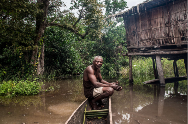
(Photo: Cameroon Indigenous person. Courtesy Sylvie Djacbou Deugoue / Greenpeace )
by Sylvie Djacbou Deugoue and Lamfu Yengong Fabrice 10 December 2019 |
“What happens in the rainforest doesn’t stay there. It affects all of us: Cameroonians and anyone who cares for human rights and for the planet. What can we do? We can raise awareness. We can get more politicians and donors behind the demand to reform land laws and policies. Finally, we can support better access for Indigenous people to the judicial system, where they can raise their just claim.”
Greenpeace is an international NGO with the head office in Amsterdam, But I am employed to work in the Congo Basin, our head office in Africa is based in South Africa.
(Photo: Greenpeace Cameroon. Courtesy Fabrice Lamfu)
Our vision as Greenpeace is to make an Africa where people live in harmony with nature in a peaceful state of environmental and social justice. Greenpeace has always been more than an organization. We have been, and are today, a movement. A diverse, multinational, multicultural movement of ordinary individuals determined to bring about extraordinary changes necessary to realize a greener, more peaceful future.
Greenpeace has 4 campaigns in in 5 countries in Africa which are; in Senegal, we do the Ocean campaigns, in South Africa, we do the Climate and energy campaign, in Kenya we do the Food for life Campaign and in DRC and Cameroon, we do the Forest campaign. I am employed to work in the Congo Basin (Cameroon and DRC), but I could jump into the Ocean campaign or food for life campaign or the energy campaign if need be in terms of maps to be produced. In the Congo Basin, we use Key influencers (Musicians, comedians…) to propagate our works, we do community based building in which the community are empowered to speak for themselves in media, we use our volunteers to run most of our petitions, we use maps (participatory and landcover change) as evidence to name and shame the illegalities in the community and we do a lot of investigations and research which I am in charge of in particulars case to expose the environmental injustice.
(Photo: Community Conservation in Cameroon. Courtesy Fabrice Lamfu)
So far in Cameroon, we succeeded to reduce the timeframe of Herakles farms operation from 99 years to 3 year renewable and the reduced the concession from 86000 Ha to 20000 Ha, we also have hampered the operation of SUDCAM, a subsidiary to Halcyon Agri based in Singapore by stopping some of the funders until some of our (Greenpeace) demands are met which are to; (1) Plant the 11,000 Ha of forest deforested and (2) To follow the FPIC procedure which was never followed. Late this year, Greenpeace was awarded the best online campaigning organization in Cameroon. In DRC, just to name a few, the Government granted a community land title to the community of Lokolama, we discovered a peatland in Lokolama and a moratorium was signed by the government to some logging concessions
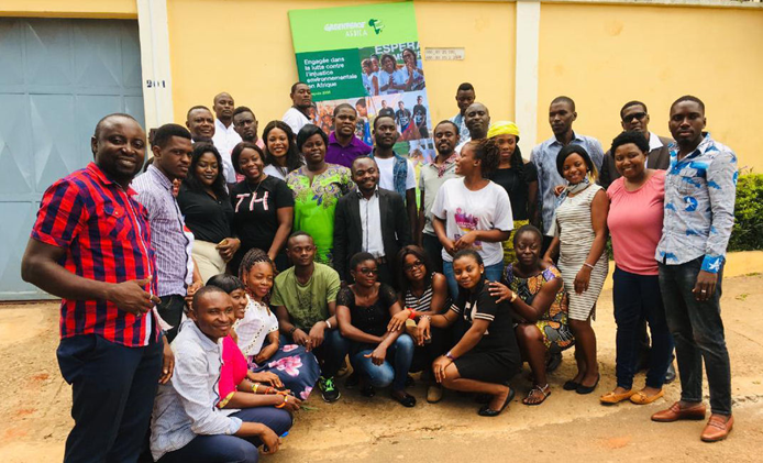
Greenpeace Africa solely works with partners organization and local communities as seen in most of our videos (I can make it available to you), Greenpeace Africa works in a broader geographical scale with its international partners and most of the results from our campaigns are propagated by our international colleagues.
(Photo: Fabrice (second from right in blue shirt) on a Greenpeace forest survey. Courtesy Fabrice Lamfu)
What is your personal role in the organization? I have been with Greenpeace Africa for the past 10 months and are fully into all the projects in the Congo Basin as a researcher. The projects within the Congo Basin include;
-Industrial Agriculture in Cameroon: I lead the field missions for investigations/research (both online and field), I have been involved with mapping of the community, I have contributed in report writing/editing and have writing some reports. Some of my successes in this project are; (1) Have published a report, (2) Produced a field investigation videos which was send to COPS 25 and have published and op ed and articles.
-Peatland in Congo Brazzaville: I did not start this project but so far, I have been able to review articles published about the peatland, have reviewed fact and figures about peatland which are used by campaigners in DRC and Cameroon,
-Community Forestry in Congo Brazzaville: I did not start the project but have contributed in finetuning the terms of reference of biodiversity and community mapping in the lokolama village.
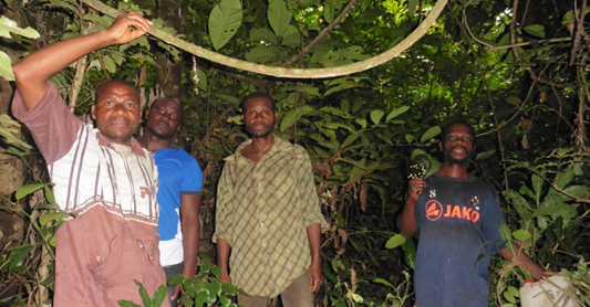
(Photo: Forest Survey in Cameroon. Courtesy Fabrice Lamfu)
Apart of the different project I am involved in, my role in the organizations are to:
--Identify strategic research needs and opportunities for Greenpeace’s Congo Basin forest campaign.
--Leads on specific campaign research and investigations works delegated. This includes preparing substantive reports, briefings and updates to inform the campaign team about research outcomes and provide recommendations. This should also be done in collaboration with international research teams.
--Build a network of institutional and individual informants. Develop alliances and maintain good relationships with various stakeholders (NGOs, administrations, companies, research institutes, communities, media …), in particular with regards to information acquisition.
--Independently plan and execute field investigations in Congo Basin countries. This might include multi-week trips to remote forest areas with very basic accommodation.
--Contribute to Greenpeace publications.
--Collaborate and maintain active working relationships with Greenpeace Africa’s security and investigation department and Greenpeace’s international Investigation and research community.
--Assume any other responsibility appropriate to the role, as directed by the International research Coordinator.
What is the history of your interest & work in conservation and GIS?
I will start by saying NO GIS, NO Conservation. The implication of this is, very little or no work can be done on conservation without the use of GIS. With the little experience I have, all presentations of biological survey, landscape survey and land change analysis are done with the use of either maps or by visualizing using google earth. In the past, I have worked with master students working on urban forestry and in National parks (some of which include the Mount Cameroon National park, The kimbi-Fundon, the Korup and many others) with the sole aim of providing proper conservation strategies, this could not be achieved without the use of GIS. In all I have done, the underlining principle is centered around biocentrism, anthropocentrism, ecocentrism and sentientism.
In addition to my work at Greenpeace, I been teaching for the past 3-4 years now in secondary schools, to professional schools and in universities within Cameroon. I have also worked with road construction companies during the execution of road projects in the Bafousam-Cameroon. Furthermore, have work as a consultant in conservation projects in national parks in Cameroon with national and grassroots organizations. Also, I have facilitated workshops/seminar in conservation in Cameroon, DRC and Nigeria.
In all of this, I have had the experience in working with community members, classrooms students and policy makers in effecting and changing the state of conservation in various projects. This work involved presenting statistic facts of a given forest, doing a power point presentation of land-use maps and biodiversity inventory maps.
Do you have any connections to your local SCGIS chapter?
I only know that there is a local SCGIS chapter in Cameroon lead by BUH WUNG GASTON, but I have not had the opportunity to communicate/met with him.
Notwithstanding, I have had discussion with SCGIS colleagues (Anya and Ilona) who belong to Greenpeace mapping hub. I have been able to learn from them even though not at length but they have been very enriching to me specially to open source data.
What is the most unique and challenging aspect about the conservation/GIS work that you do?
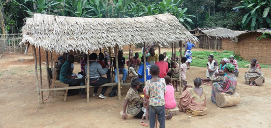
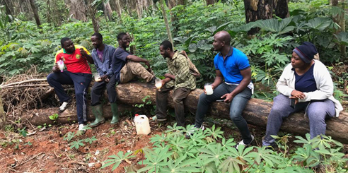
The most exciting activity within my project is GPS points collection with the community members. With this approach, we allow the community to fully participate in the project and gain our trust for information sharing. Since most of our projects are in rural communities, I face lots of problems some of which includes:
- Poor road access: This could lead to road accidents and delays (passing a night or two travelling).
- Poor internet connection and local network: In most of this communities, we do not have internet communication and local networks for call.
- Lack of electricity: most of the community operate using a generator as their source of electricity, making communication difficult.
All the community related problems reflect the context in which we carry out our work. I must confess this is the beauty of Africa where research becomes very difficult.
What are your Conservation & GIS capabilities & Expertise?:
Growing up as a child, I developed interest in GIS. While at the university, with the help of Dr. Wantim Mable, who taught me the basics of GIS, I was able to study on my own using you-tube and exploring different software’s like;
--ENVI 4.4 With this software, I have been able to remotely sensed different areas within Cameroon and DRC and doing a landcover change analysis/maps by doing supervised classification with images of different years interval after which, used the results from the analysis for modeling using MINITAB or R.
--Mapsource and dnrgps (with this software’s, converting GPX points to shapefile has been very easy for me),
--ArcGIS 10.2.1 has been the most used software’s for the past years in which I have been able to produce topo maps with and without DEM, Visualization of points, produced participatory maps, land-use maps for policy implication,
--Google earth pro has been very instrumental to me when it comes to visualization of vegetation, location and investigative studies in the ports of DRC and Cameroon and also
--TCX converter which helps me to convert KMZ file format from Google earth pro to produce DEM in ArcGIS.
I have been able to train students at the university on the production of topographic maps, interpretation of Settlelite images and basic analysis (change detection), use of GPS in participatory mapping. All this has been done with beginner knowledge.
In 2015, I passed through the hands of Dr. Wantim Mabel, who thought me some basics (georeferencing, digitizing and classification). I was also opportune in 2016 to have been taught by Akenji Lesly who gave me some basic on the use of GPS, Mapsource and dnrgps (these are tools which help in creating/manipulating on different file format type). For the past 3 years, I have been visiting YouTube when I am faced with challenges. This has greatly increased my scope and ability on GIS. In July 2019, I attended a skill share in Philippine organized by Greenpeace investigation team in which I learned from the open data source presentation presented by Ilona. Finally, in December 2019, I organized a geomatic training in Cameroon Yaounde with trainers from Russia (Anya Komarova) and France (Adrien CORVISY). In this training, I was able to learn basic introduction into QGIS (uploading, georeferencing and production of maps).
My past experience has been so enriching and looking forward to expert who will increase my scope in ArcGIS pro which I use it almost on a daily basis in our campaign in the Congo Basin.
What are your current Conservation GIS interests & challenges?
Given that my priority which is the forest and also the fact that my GIS lessons have not be chronological (most of my learning process are done online), I shall list my difficulties encountered in my projects;
Deforestation: this has been a nightmare in the Congo Basin, but I have not been able to have with figures on all the drivers of deforestation and their percentage of contribution over the past years. In addition to that I also faced the problem with modelling, this is also an integral part of my project which help me to give more information to the campaigners and communication about facts and trends of deforestation and its drivers.
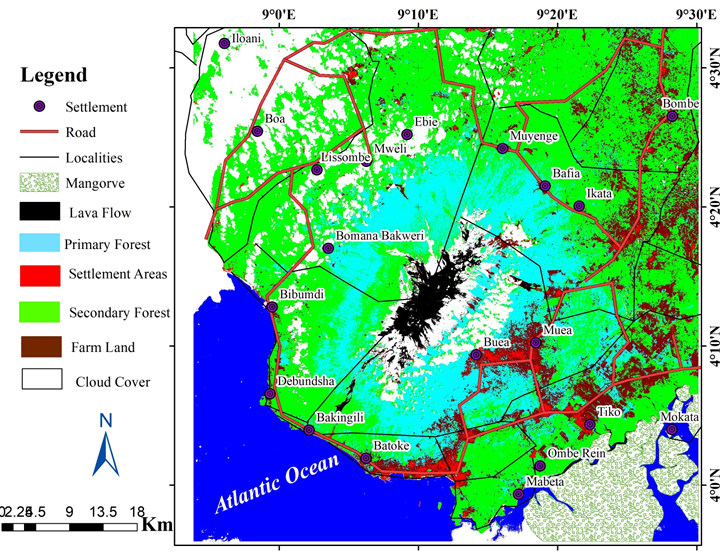
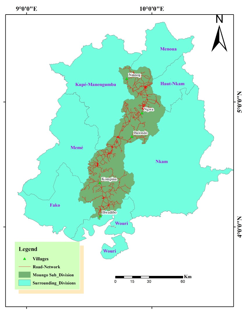
(Map: Forest Survey in Cameroon. Courtesy Fabrice Lamfu)
Forest Inventory: This is also a difficult for me because I have very little information relating to monitoring, planning, research and evaluation. All this monitoring information are related to biodiversity (flora and fauna) which is very important to our specific campaigns and projects in the Congo Basin. Having a better understanding on the qualitative and quantitative information/analysis about the forest in our specific campaign region will help me in plaining better for the biodiversity therein.
Illegal logging: Requesting for any technique that can be used to monitor illegal logging in the specific area where we carry out our campaigns. I know in the developed world, this is pretty easy but, in our context, I would be very happy if that technique could be shared. This will be a very big plus to the Congo Basin where illegal logging is very rampant.
Forest Carbon Reserves: This is one of the most important study which I have to undertake in the 3-year strategy plan of Greenpeace Africa but I do not have an idea of how to remotely sense our specific area of campaign. Here, I am talking of above ground carbon (ABG) stock.
2020 Paper you will present: Worried about biodiversity? End Industrial Activity in the Rainforest
2020 Abstract/summary of the paper you will present: Biodiversity loss is a global crisis. In May this year, the UN warned that over 1,000,000 species are threatened worldwide. The details are grim: tropical rainforests are estimated to harbour more than half of the world’s plant and animal species. They are also essential for access to water, regulating temperature, and preventing soil erosion. In Cameroon, they are being degraded by industrial logging and cleared to create oil palm and rubber plantations in the south region of Cameroon. This paper seeks to address the present happenings in the South Region of Cameroon leading to the question on Biodiversity. Results shows that, The Dja Faunal Reserve, a UNESCO world heritage site in the South of Cameroon, is home to more than 100 species of mammals, including at least 14 primates, such as the endangered western lowland gorilla, chimpanzee, and white-collared mangabey, as well as species such as the endangered forest elephant, and the nearly extinct African gray parrot, bongo and leopard [1]. It is also adjacent to the Sudcam rubber plantation, mainly owned by rubber giant Halcyon Agri. The plantation has rattled the lives of several indigenous communities,
x2020 x2020Scholar x2020Talk xAfrica xCameroon xClimate xFire xForest xRemote xSustainable xMonitoring xBiodiversity xStatistics xAgriculture xCommunity xIndigenous xPlan xPOC
-
 Anonymous User