- Home
- :
- All Communities
- :
- User Groups
- :
- CAD/GIS Data Integration
- :
- Questions
- :
- Re: Pull up Scanned Maps in the Field
- Subscribe to RSS Feed
- Mark Topic as New
- Mark Topic as Read
- Float this Topic for Current User
- Bookmark
- Subscribe
- Mute
- Printer Friendly Page
- Mark as New
- Bookmark
- Subscribe
- Mute
- Subscribe to RSS Feed
- Permalink
I work for a small utility company and I am in the process of scanning hundreds of old construction plans and as-builts from around the area. My plan is to georeference some of these maps and have them available for crews working in the field. I currently have it where some hand drawings can be accessed by links in the attribute tables but these are for single features. The drawings that I am scanning cover large areas and I am wondering what the best way would be so that if they are in an area, they could click on that area in the Collector App and the scanned map would show up. I have thought about making a Polygon layer that would outline the area covered by the maps, and adding links in the attributes for those polygons. The only issue there would be that many of these features may overlap or even encompass others (Smaller scale Overview drawings with multiple larger scale drawings within them). Does anyone have any suggestions on a good way to have these maps available to field workers so that they could click on a location and a scanned map pops up?
Solved! Go to Solution.
Accepted Solutions
- Mark as New
- Bookmark
- Subscribe
- Mute
- Subscribe to RSS Feed
- Permalink
Yes, that sounds about right. According to the documentation the storage costs for attachments is 1.2 credits per 1 GB per month.
Understand credits—ArcGIS Online Help | ArcGIS
Leon
- Mark as New
- Bookmark
- Subscribe
- Mute
- Subscribe to RSS Feed
- Permalink
Have you looked and the Plans and Drawings solution? Plans and Drawings | ArcGIS Solutions for Local Government
We started implementing it a year ago and its been very helpful. You basically create polygons for plan extents and add the plans as an attachment to the feature.
Leon
- Mark as New
- Bookmark
- Subscribe
- Mute
- Subscribe to RSS Feed
- Permalink
Thanks Leon! I'll check it out.
- Mark as New
- Bookmark
- Subscribe
- Mute
- Subscribe to RSS Feed
- Permalink
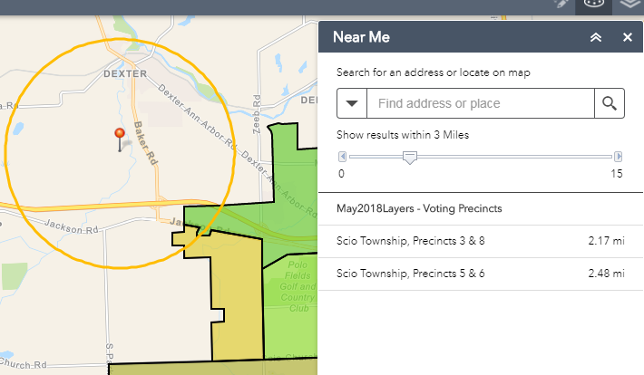
It looks like that Plans and Drawings solution is built with Web App Builder. You could add a Near Me widget to help users select all plans near the area they will be, even if the polygons overlap. Works well on mobile devices too.
- Mark as New
- Bookmark
- Subscribe
- Mute
- Subscribe to RSS Feed
- Permalink
The Plans and Drawings solution seems to be working great. Just to be clear, the attachments to the features would only use 1.2 credits a month per GB correct?
- Mark as New
- Bookmark
- Subscribe
- Mute
- Subscribe to RSS Feed
- Permalink
Is that price based on the size of images being stored? If so, could it get expensive if you have color images that are much larger in size than b/w images?
- Mark as New
- Bookmark
- Subscribe
- Mute
- Subscribe to RSS Feed
- Permalink
I have scanned about 60% of our drawings and I'm at around 1500 files totaling 1.6 GB. The majority of the maps are B/W but there are some color. I am anticipating that once all is said and done I will have around 2.5 GB of scanned documents. I don't anticipate having to attach every single document though. So if I am understanding the credit consumption, if i have around 2 GB of attachments that should only run me about 2.4 credits a month. Does this seem right?
- Mark as New
- Bookmark
- Subscribe
- Mute
- Subscribe to RSS Feed
- Permalink
Yes, that sounds about right. According to the documentation the storage costs for attachments is 1.2 credits per 1 GB per month.
Understand credits—ArcGIS Online Help | ArcGIS
Leon
- Mark as New
- Bookmark
- Subscribe
- Mute
- Subscribe to RSS Feed
- Permalink
Alex,
Will your current annual-credit-allotment allow you to sustain this large amount of data on your AGOL account? And is everything else working out ok?
- Mark as New
- Bookmark
- Subscribe
- Mute
- Subscribe to RSS Feed
- Permalink
2.4 credits a month shouldn't have much of an effect for us. Everything is working great. I will post updates as I make more progress.