Turn on suggestions
Auto-suggest helps you quickly narrow down your search results by suggesting possible matches as you type.
Cancel
- Home
- :
- All Communities
- :
- Products
- :
- ArcPad
- :
- ArcPad Questions
- :
- The meaning of the PDOP, kph in the ArcPad,
Options
- Subscribe to RSS Feed
- Mark Topic as New
- Mark Topic as Read
- Float this Topic for Current User
- Bookmark
- Subscribe
- Mute
- Printer Friendly Page
01-12-2014
11:56 AM
- Mark as New
- Bookmark
- Subscribe
- Mute
- Subscribe to RSS Feed
- Permalink
The meaning of the PDOP, kph in the ArcPad,
I couldn???t figure out how to read the information provided in the screenshots below
[ATTACH=CONFIG]30436[/ATTACH], [ATTACH=CONFIG]30437[/ATTACH]
Thank you
Best
Jamal
I couldn???t figure out how to read the information provided in the screenshots below
[ATTACH=CONFIG]30436[/ATTACH], [ATTACH=CONFIG]30437[/ATTACH]
Thank you
Best
Jamal
----------------------------------------
Jamal Numan
Geomolg Geoportal for Spatial Information
Ramallah, West Bank, Palestine
Jamal Numan
Geomolg Geoportal for Spatial Information
Ramallah, West Bank, Palestine
Solved! Go to Solution.
1 Solution
Accepted Solutions
by
Anonymous User
Not applicable
01-12-2014
04:43 PM
- Mark as New
- Bookmark
- Subscribe
- Mute
- Subscribe to RSS Feed
- Permalink
Original User: HannahFerrier
Hello,
The GPS Status Bar contains a lot of useful information.
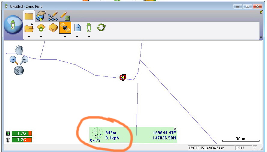
The values you have indicated in your question are the altitude (m) and speed (kmph) of your GPS position.
[ATTACH=CONFIG]30438[/ATTACH]
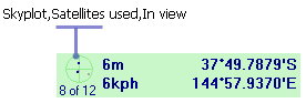
The GPS Status Bar also indicates the number of satellites that are being used as well as the number of satellites in view with the GPS skyplot.
[ATTACH=CONFIG]30439[/ATTACH]
You can also see the signal strength of the satellites and the PDOP value. PDOP stands for Positional Dilution of Precision and is a value between 0-99 to indicate positional accuracy (the lower the number, the more accurate the position). Mapping grade projects usually require a PDOP of 6.0 or less, with survey grade projects requiring a PDOP of 4.0 or less.
[ATTACH=CONFIG]30440[/ATTACH]
See here for more information on GPS dilution of precision, including how PDOP is calculated.
Hope this helps,
Hannah 🙂
Hello,
The GPS Status Bar contains a lot of useful information.
The values you have indicated in your question are the altitude (m) and speed (kmph) of your GPS position.
[ATTACH=CONFIG]30438[/ATTACH]
The GPS Status Bar also indicates the number of satellites that are being used as well as the number of satellites in view with the GPS skyplot.
[ATTACH=CONFIG]30439[/ATTACH]
You can also see the signal strength of the satellites and the PDOP value. PDOP stands for Positional Dilution of Precision and is a value between 0-99 to indicate positional accuracy (the lower the number, the more accurate the position). Mapping grade projects usually require a PDOP of 6.0 or less, with survey grade projects requiring a PDOP of 4.0 or less.
[ATTACH=CONFIG]30440[/ATTACH]
See here for more information on GPS dilution of precision, including how PDOP is calculated.
Hope this helps,
Hannah 🙂
2 Replies
by
Anonymous User
Not applicable
01-12-2014
04:43 PM
- Mark as New
- Bookmark
- Subscribe
- Mute
- Subscribe to RSS Feed
- Permalink
Original User: HannahFerrier
Hello,
The GPS Status Bar contains a lot of useful information.
The values you have indicated in your question are the altitude (m) and speed (kmph) of your GPS position.
[ATTACH=CONFIG]30438[/ATTACH]
The GPS Status Bar also indicates the number of satellites that are being used as well as the number of satellites in view with the GPS skyplot.
[ATTACH=CONFIG]30439[/ATTACH]
You can also see the signal strength of the satellites and the PDOP value. PDOP stands for Positional Dilution of Precision and is a value between 0-99 to indicate positional accuracy (the lower the number, the more accurate the position). Mapping grade projects usually require a PDOP of 6.0 or less, with survey grade projects requiring a PDOP of 4.0 or less.
[ATTACH=CONFIG]30440[/ATTACH]
See here for more information on GPS dilution of precision, including how PDOP is calculated.
Hope this helps,
Hannah 🙂
01-16-2014
10:46 AM
- Mark as New
- Bookmark
- Subscribe
- Mute
- Subscribe to RSS Feed
- Permalink
Hello,
The GPS Status Bar contains a lot of useful information.
The values you have indicated in your question are the altitude (m) and speed (kmph) of your GPS position.
[ATTACH=CONFIG]30438[/ATTACH]
The GPS Status Bar also indicates the number of satellites that are being used as well as the number of satellites in view with the GPS skyplot.
[ATTACH=CONFIG]30439[/ATTACH]
You can also see the signal strength of the satellites and the PDOP value. PDOP stands for Positional Dilution of Precision and is a value between 0-99 to indicate positional accuracy (the lower the number, the more accurate the position). Mapping grade projects usually require a PDOP of 6.0 or less, with survey grade projects requiring a PDOP of 4.0 or less.
[ATTACH=CONFIG]30440[/ATTACH]
See here for more information on GPS dilution of precision, including how PDOP is calculated.
Hope this helps,
Hannah 🙂
Many thanks Hannah for the help. This is very useful.
Our GPS machine (Leica CS25) is supposed to provide an accuracy of +/- 1 cm when it works with RTK. Then how to interpret the values of PDOP in cm?
In other works, if the value of PDOP is 4 when what is its equivalent value in cm?
----------------------------------------
Jamal Numan
Geomolg Geoportal for Spatial Information
Ramallah, West Bank, Palestine
Jamal Numan
Geomolg Geoportal for Spatial Information
Ramallah, West Bank, Palestine