Turn on suggestions
Auto-suggest helps you quickly narrow down your search results by suggesting possible matches as you type.
Cancel
- Home
- :
- All Communities
- :
- Products
- :
- ArcPad
- :
- ArcPad Questions
- :
- Re: The Antenna is kept as the same point while ca...
Options
- Subscribe to RSS Feed
- Mark Topic as New
- Mark Topic as Read
- Float this Topic for Current User
- Bookmark
- Subscribe
- Mute
- Printer Friendly Page
The Antenna is kept as the same point while captured coordinates keep changing!
Subscribe
2466
5
01-12-2014 11:28 AM
01-12-2014
11:28 AM
- Mark as New
- Bookmark
- Subscribe
- Mute
- Subscribe to RSS Feed
- Permalink
- Report Inappropriate Content
The Antenna is kept as the same point while captured coordinates keep changing!
I�??m using Leica CS25 GPS (GG03 Antenna + Zeno Field software + RTK), nevertheless, the captured point keeps changing despite the fact that the antenna is kept at the same point
[ATTACH=CONFIG]30426[/ATTACH], [ATTACH=CONFIG]30427[/ATTACH]
My understanding that the differential GPS (Leica CS25) has -/+ 2cm as accuracy
What might be the issue here?
Thank you
Best
Jamal
----------------------------------------
Jamal Numan
Geomolg Geoportal for Spatial Information
Ramallah, West Bank, Palestine
Jamal Numan
Geomolg Geoportal for Spatial Information
Ramallah, West Bank, Palestine
5 Replies
01-13-2014
05:11 AM
- Mark as New
- Bookmark
- Subscribe
- Mute
- Subscribe to RSS Feed
- Permalink
- Report Inappropriate Content
What was your estimated positional accuracy? I would assume you did not have a RTK fixed solution at the time so that is why the coordinate values varied.
by
Anonymous User
Not applicable
01-16-2014
10:12 AM
- Mark as New
- Bookmark
- Subscribe
- Mute
- Subscribe to RSS Feed
- Permalink
- Report Inappropriate Content
Original User: Jamal432@gmail.com
Many thanks Brett for the help.
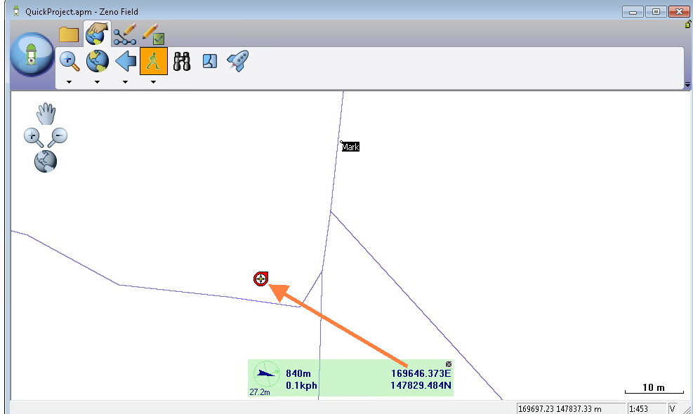
Yes I do use the RTK as shown in the screenshot below.
[ATTACH=CONFIG]30580[/ATTACH]
Then how come values do vary?
What was your estimated positional accuracy? I would assume you did not have a RTK fixed solution at the time so that is why the coordinate values varied.
Many thanks Brett for the help.
Yes I do use the RTK as shown in the screenshot below.
[ATTACH=CONFIG]30580[/ATTACH]
Then how come values do vary?
01-16-2014
11:36 AM
- Mark as New
- Bookmark
- Subscribe
- Mute
- Subscribe to RSS Feed
- Permalink
- Report Inappropriate Content
If receiving RTK corrections and my estimated positional error is at 1 cm then my coordinate values are all well within specification. You should compare your X, Y, Z values.
by
Anonymous User
Not applicable
01-16-2014
12:08 PM
- Mark as New
- Bookmark
- Subscribe
- Mute
- Subscribe to RSS Feed
- Permalink
- Report Inappropriate Content
Original User: Jamal432@gmail.com
Thanks Brett.
This is the issue.
How come while I�??m having RTK corrections and still the value captured at a particular point varies with a difference that exceeds the accuracy (1 cm)?
Why the captured XYZ varies while the antenna is fixed on the same point?
If receiving RTK corrections and my estimated positional error is at 1 cm then my coordinate values are all well within specification. You should compare your X, Y, Z values.
Thanks Brett.
This is the issue.
How come while I�??m having RTK corrections and still the value captured at a particular point varies with a difference that exceeds the accuracy (1 cm)?
Why the captured XYZ varies while the antenna is fixed on the same point?
01-17-2014
04:37 AM
- Mark as New
- Bookmark
- Subscribe
- Mute
- Subscribe to RSS Feed
- Permalink
- Report Inappropriate Content
Jamal,
There are a lot of unknowns about your network, how you are configuring your project, ArcPad/Zeno Field, etc. You had mentioned prior that you are modifying the GPS datum in Zeno Field, which is not recommended as all transformations are handled by Zeno Office/Zeno Office on ArcGIS. Also, what coordinate system is your GPS reference network sending the corrections in?
I would highly recommend some level of training (on-site or web-based) as I do not experience any of the difficulties that you have to date. When I connect to a local real-time network (RTCM3_IMAX mountpoint), receive RTK corrections to 1 cm and check into a control monument with established coordinates I check well within the GNSS accuracy stated by the GG03.
If you set the GG03 up on a known point, are receiving RTK corrections to a phase-fixed 1 cm solution and are not moving while storing 3 separate points, all three of the X, Y, Z values of these survey points in Zeno Office/Zeno Office on ArcGIS should be in the centimeter range. If not, you have a configuration issue.