- Home
- :
- All Communities
- :
- Products
- :
- ArcPad
- :
- ArcPad Questions
- :
- Re: Arcpad Projection Issue
- Subscribe to RSS Feed
- Mark Topic as New
- Mark Topic as Read
- Float this Topic for Current User
- Bookmark
- Subscribe
- Mute
- Printer Friendly Page
Arcpad Projection Issue
- Mark as New
- Bookmark
- Subscribe
- Mute
- Subscribe to RSS Feed
- Permalink
- Report Inappropriate Content
Arcpad Projection Issue
Hello,
I am having a devil of a time with projection issues getting an image into Arcpad. I am using Arcgis 10.3 and Acpad 10.2.2. I have done the following:
Since there are two overlapping images, in Arcmap I have exported the area of interest as a tif with the tfw option checked. I added it to Arcmap and it displayed properly.
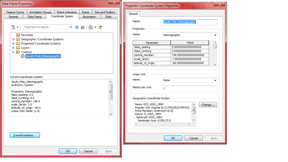
I then used Project Raster tool to project the image in the South Pole Stereographic Projection with a central meridian of 156 (156 E) (which also matches the Data Frame Properties)
I brought the image into Arcmap to see if it displayed properly, and it did, with the Properties showing the proper projection parameters.
I then used the Arcpad Data Manage to assemble the image and the feature class files. The feature class shapefile .prjs all show the proper projections.
When I start the Arcpad map, the message that “The projection for layer ****** doesn’t match the current map projection”. The image displays, BUT the longitude shows as in the 0 degrees range and the Map Projection Properties in Arcpad shows the Central Meridian to be 0! So it seems like Arcpad is not recognizing the central meridian. (When I bring the image into a new Arcmap session the central meridian of 156 is recognized, so the projection information is there somewhere)
In Arcpad I then selected the Choose Map Projection Definition File and chose one of the feature .prj. The longitude shown on the status bar now shows the proper longitude range. I then added the feature layers and, low and behold, everything displays as it should. I saved the file. When re-opening the .apm I am back to the beginning again and have to go through this whole process again. (Note: I even took one of the feature .prjs, copied it and renamed it with the image file name. Didn’t seem to help).
Sheesh, is it supposed to be this hard? What am I doing wrong? Any thoughts are appreciated.
Thanks much,
John
- Mark as New
- Bookmark
- Subscribe
- Mute
- Subscribe to RSS Feed
- Permalink
- Report Inappropriate Content
Just a quick question... When you are trying to confirm that the projected file is correct in ArcMap are you doing it in a new dataframe, and it is the only file added, or at least added first? Just want to confirm because the first file added sets the coordinate system of the dataframe. Also, what utm zone are you in? Does it defining the W(est) equivalent change things? since you are close to +/- 180
- Mark as New
- Bookmark
- Subscribe
- Mute
- Subscribe to RSS Feed
- Permalink
- Report Inappropriate Content
Dan,
Thank you for your response. I usually try and define the data frame projection before populating it with layers, but sometimes forget that step. But I have checked both the data frame projection and the layer projection and they are the same. Because we are at 83 South I am using Polar Stereographic projection with a central meridian of 156 E. Shouldn’t be an issue with being close to 180.
I should also note that in Arcpad when I load the feature shapefiles first and then add the image layer, I get the “The projection for layer ****** doesn’t match the current map projection” message and the image layer fails to load.
Thanks,
John
- Mark as New
- Bookmark
- Subscribe
- Mute
- Subscribe to RSS Feed
- Permalink
- Report Inappropriate Content
John,
have you read thru these two help topics?
the he first link talks about how ArcPad would automatically select a projection. The second talks about how to manually set the projection for the project. I would suggest trying the second option....but my guess is the raster isn't really the projection you think it is, or doesn't have the info set, and ArcPad doesnt know how to deal with it (and will not project rasters on the fly....if never used to anyway)
- Mark as New
- Bookmark
- Subscribe
- Mute
- Subscribe to RSS Feed
- Permalink
- Report Inappropriate Content
Hello,
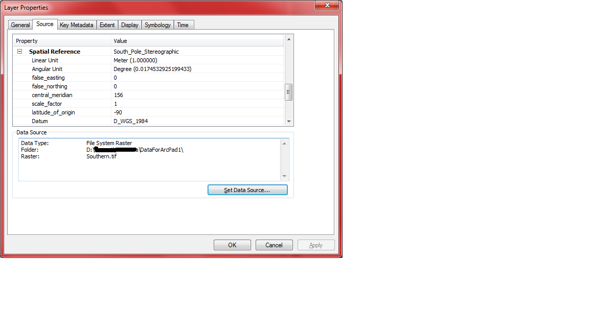
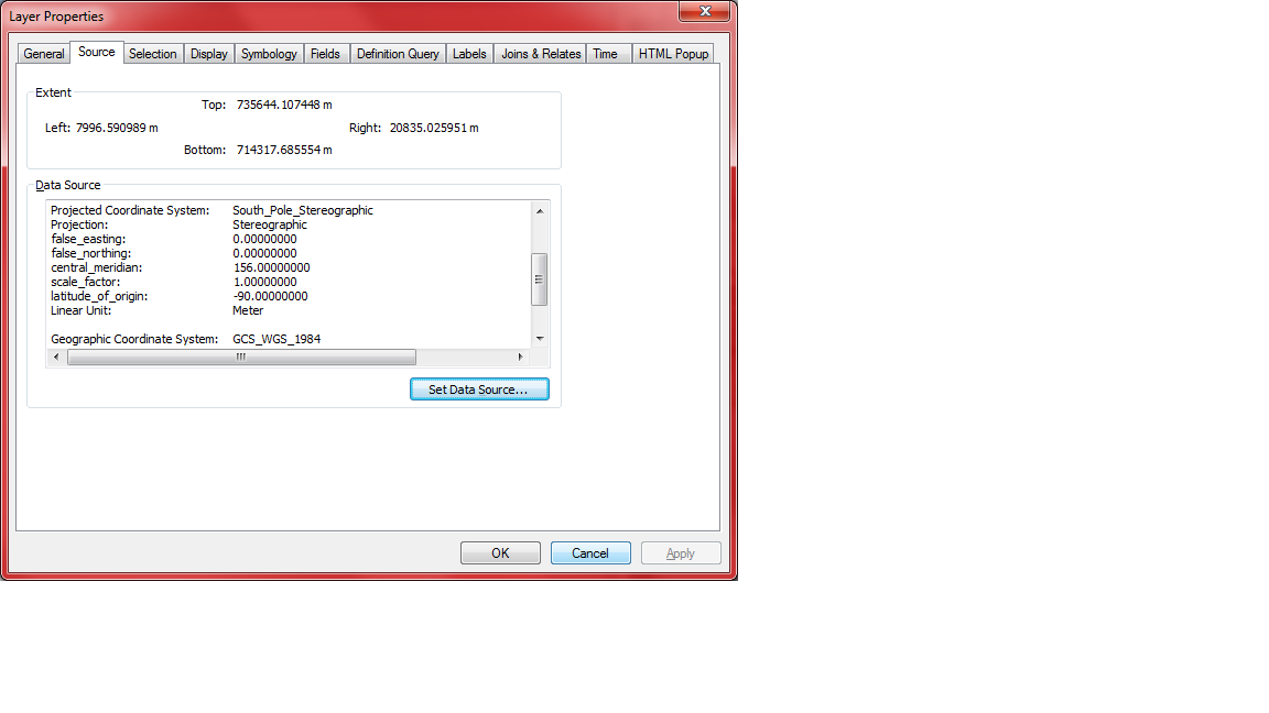
Thanks Rebecca and Dan for your comments. I had previously perused the help files and other posts found online and believe I understand the requirements, which is the reason I am really bugged about this issue. Please see the attached images which show that the image and the feature layers all have the same projection in Arcmap. Yet when they are brought into Arcpad by using the Arcpad Data Manager in Arcmap the projection of the image seems to be reset to a central meridian of 0 degrees instead of 156 I had specified for the South Polar Stereographic Projection. The issue is not resolved even if I create a new Arcpad map and manually add in the image and feature files. I have used the method 2 as you had suggested to manually set the map projection and then add the feature layers to get a usable map, but on saving the map the manual change is not preserved.
Cheers,
John

- Mark as New
- Bookmark
- Subscribe
- Mute
- Subscribe to RSS Feed
- Permalink
- Report Inappropriate Content
Just a thought....
"South Pole Stereographic" is a standard projection in the system.
When you redefined it to a central meridian of 156, you didn't rename it to "South Pole Stereographic My version" or something.
Perhaps ArcPad is looking up the original version somehow and ignoring the change.
- Mark as New
- Bookmark
- Subscribe
- Mute
- Subscribe to RSS Feed
- Permalink
- Report Inappropriate Content
John, if this still isn't resolved you should file an incident with tech support
- Mark as New
- Bookmark
- Subscribe
- Mute
- Subscribe to RSS Feed
- Permalink
- Report Inappropriate Content
Hola John,
Here is a really good technical article that might assist in what you are attempting to do with the raster for use in ArcPad. If this does not resolve the issue, as Dan suggested, just log a support case with us in Support Services. Good Luck, John!
HowTo: Prepare raster data for use within the ArcPad disconnected environment
41322 - Prepare raster data for use within the ArcPad disconnected environment
Juan