Turn on suggestions
Auto-suggest helps you quickly narrow down your search results by suggesting possible matches as you type.
Cancel
- Home
- :
- All Communities
- :
- Developers
- :
- ArcObjects SDK (Retired)
- :
- ArcObjects SDK Questions
- :
- Incomplete Polyline
Options
- Subscribe to RSS Feed
- Mark Topic as New
- Mark Topic as Read
- Float this Topic for Current User
- Bookmark
- Subscribe
- Mute
- Printer Friendly Page
06-19-2012
03:51 AM
- Mark as New
- Bookmark
- Subscribe
- Mute
- Subscribe to RSS Feed
- Permalink
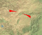
I am trying to draw a polyline in a custom tool (BaseTool) on a AxGlobeControl (from 3DAnalyst) but I am not getting a continuous line. Instead I get an arch with the center missing.
The process I am using is from the examples. I am creating a new GlobeGraphicsLayer and adding it to the scene I get from the GlobeHookHelperClass provided in the overridden BaseTool.OnCreate(). I am also creating a Polyline by defining the start and end Points. I set a LineElement's geometry to the polyline and add it to the layer and this is what I get (the width is 10 so that more of the line displays).
[ATTACH=CONFIG]15312[/ATTACH]
Any ideas what I am missing? Could there be an issue with the zoom level or camera position?
Solved! Go to Solution.
1 Solution
Accepted Solutions
06-20-2012
04:26 AM
- Mark as New
- Bookmark
- Subscribe
- Mute
- Subscribe to RSS Feed
- Permalink
The key was to use the MeasurementTool from DefenseSolutions.
private void DrawRhumbLine(IPoint fromPoint, IPoint toPoint)
{
if (fromPoint == null || toPoint == null)
return;
try
{
IColor rgbColor = new RgbColorClass();
rgbColor.RGB = 255;
IPolyline polyline = CreateGeoPolyline(fromPoint, toPoint);
ISimpleLineSymbol simpleLineSymbol = new SimpleLineSymbolClass();
simpleLineSymbol.Color = rgbColor;
simpleLineSymbol.Style = esriSimpleLineStyle.esriSLSSolid;
simpleLineSymbol.Width = 2;
ILineElement lineElement = new LineElementClass();
lineElement.Symbol = simpleLineSymbol;
IElement element = (IElement)lineElement; // Explicit Cast
element.Geometry = polyline;
m_globeGraphicsLayer.AddElement(element, 1);
}
catch (Exception ex)
{
logger.Error("Draw Rhumb Line encountered and error. {0}", ex.Message);
}
}
private IPolyline CreateGeoPolyline(IPoint startPoint, IPoint endPoint)
{
try
{
// Set the measurement tool and the GeoPolyline. The measurement tool
// will be used to calculate the distance and azimuth of the GeoPolyline
// based on the start and end point coordinates of the line
GeoPolyline geoPolyline = new ESRI.ArcGIS.DefenseSolutions.GeoPolyline();
IMeasurementTool measurementTool = new ESRI.ArcGIS.DefenseSolutions.MeasurementTool();
// Get the GeoPolyline type from the Type dropdown list and set it as
// the type for both the measurement tool and the GeoPolyline. The options
// are Geodesic, Great Circle, and Rhumb Line.
measurementTool.SpecialGeolineType = ESRI.ArcGIS.DefenseSolutions.cjmtkSGType.cjmtkSGTRhumbLine;
geoPolyline.SpecialGeolineType = ESRI.ArcGIS.DefenseSolutions.cjmtkSGType.cjmtkSGTRhumbLine;
// Define the spatial reference of the rhumb line.
// Define the spatial reference to be used for geopolylines,
// geoellipses, and geopolygons.
ESRI.ArcGIS.Geometry.ISpatialReferenceFactory2 pSpatRefFact = (ISpatialReferenceFactory2) new ESRI.ArcGIS.Geometry.SpatialReferenceEnvironment();
ISpatialReference2 spatialReference2 = (ISpatialReference2) pSpatRefFact.CreateSpatialReference((int) ESRI.ArcGIS.Geometry.esriSRGeoCSType.esriSRGeoCS_WGS1984);
// Initialize the MeasurementTool and define the properties of the line.
// These properties include the line type, which is a rhumb line in this case, and the
// spatial reference of the line.
measurementTool.SpecialGeolineType = cjmtkSGType.cjmtkSGTRhumbLine;
measurementTool.SpecialSpatialReference = spatialReference2;
// Determine the distance and azimuth of the rhumb line based on the start and end point coordinates.
measurementTool.ConstructByPoints(startPoint, endPoint);
geoPolyline.MaxPercent = 0.01;
geoPolyline.UsePercent = true;
IPolyline polyline = measurementTool.get_Polyline(1000);
return measurementTool.get_Polyline(1000);
}
catch (Exception error)
{
logger.Error("There was a problem creating the rhumb line. {0}", error.Message);
}
return null;
}
1 Reply
06-20-2012
04:26 AM
- Mark as New
- Bookmark
- Subscribe
- Mute
- Subscribe to RSS Feed
- Permalink
The key was to use the MeasurementTool from DefenseSolutions.
private void DrawRhumbLine(IPoint fromPoint, IPoint toPoint)
{
if (fromPoint == null || toPoint == null)
return;
try
{
IColor rgbColor = new RgbColorClass();
rgbColor.RGB = 255;
IPolyline polyline = CreateGeoPolyline(fromPoint, toPoint);
ISimpleLineSymbol simpleLineSymbol = new SimpleLineSymbolClass();
simpleLineSymbol.Color = rgbColor;
simpleLineSymbol.Style = esriSimpleLineStyle.esriSLSSolid;
simpleLineSymbol.Width = 2;
ILineElement lineElement = new LineElementClass();
lineElement.Symbol = simpleLineSymbol;
IElement element = (IElement)lineElement; // Explicit Cast
element.Geometry = polyline;
m_globeGraphicsLayer.AddElement(element, 1);
}
catch (Exception ex)
{
logger.Error("Draw Rhumb Line encountered and error. {0}", ex.Message);
}
}
private IPolyline CreateGeoPolyline(IPoint startPoint, IPoint endPoint)
{
try
{
// Set the measurement tool and the GeoPolyline. The measurement tool
// will be used to calculate the distance and azimuth of the GeoPolyline
// based on the start and end point coordinates of the line
GeoPolyline geoPolyline = new ESRI.ArcGIS.DefenseSolutions.GeoPolyline();
IMeasurementTool measurementTool = new ESRI.ArcGIS.DefenseSolutions.MeasurementTool();
// Get the GeoPolyline type from the Type dropdown list and set it as
// the type for both the measurement tool and the GeoPolyline. The options
// are Geodesic, Great Circle, and Rhumb Line.
measurementTool.SpecialGeolineType = ESRI.ArcGIS.DefenseSolutions.cjmtkSGType.cjmtkSGTRhumbLine;
geoPolyline.SpecialGeolineType = ESRI.ArcGIS.DefenseSolutions.cjmtkSGType.cjmtkSGTRhumbLine;
// Define the spatial reference of the rhumb line.
// Define the spatial reference to be used for geopolylines,
// geoellipses, and geopolygons.
ESRI.ArcGIS.Geometry.ISpatialReferenceFactory2 pSpatRefFact = (ISpatialReferenceFactory2) new ESRI.ArcGIS.Geometry.SpatialReferenceEnvironment();
ISpatialReference2 spatialReference2 = (ISpatialReference2) pSpatRefFact.CreateSpatialReference((int) ESRI.ArcGIS.Geometry.esriSRGeoCSType.esriSRGeoCS_WGS1984);
// Initialize the MeasurementTool and define the properties of the line.
// These properties include the line type, which is a rhumb line in this case, and the
// spatial reference of the line.
measurementTool.SpecialGeolineType = cjmtkSGType.cjmtkSGTRhumbLine;
measurementTool.SpecialSpatialReference = spatialReference2;
// Determine the distance and azimuth of the rhumb line based on the start and end point coordinates.
measurementTool.ConstructByPoints(startPoint, endPoint);
geoPolyline.MaxPercent = 0.01;
geoPolyline.UsePercent = true;
IPolyline polyline = measurementTool.get_Polyline(1000);
return measurementTool.get_Polyline(1000);
}
catch (Exception error)
{
logger.Error("There was a problem creating the rhumb line. {0}", error.Message);
}
return null;
}