- Home
- :
- All Communities
- :
- Products
- :
- ArcMap (Retired)
- :
- ArcMap Questions
- :
- Why do my point features from geocoding long/lat e...
- Subscribe to RSS Feed
- Mark Topic as New
- Mark Topic as Read
- Float this Topic for Current User
- Bookmark
- Subscribe
- Mute
- Printer Friendly Page
Why do my point features from geocoding long/lat end up in the wrong place?
- Mark as New
- Bookmark
- Subscribe
- Mute
- Subscribe to RSS Feed
- Permalink
Hi there,
I have a set of addresses in a csv file for London, UK, I have used an online geocoder to get long/lat for these addresses.
I then added this csv file to ArcMap 10.7.1 successfully as a table.
I then used 'Display XY data' by right clicking on the table in the layers panel. When I do this I successful create point features for all these locations but they are clearly in the incorrect projected coordinate system as they are placed in the south Atlantic Ocean, rather than London, UK.
I have tried the 'Project' tool from my ArcToolbox to try and re-project in a different coordinate system but continue to have the same issue.
I am sure this has something to do with how I am inputting the longitude and latitude and it not being compatible with the coordinate system that I am putting this data into, but have been struggling all day with this. I'm quite new to this so would really appreciate any advice or help.
Many thanks
Katy
Solved! Go to Solution.
Accepted Solutions
- Mark as New
- Bookmark
- Subscribe
- Mute
- Subscribe to RSS Feed
- Permalink
@Anonymous User
Open a blank ArcMap session, set your coordinate system to "Geographic"> "World"> WGS84 before you start doing anything.
Then add your csv and display xy, picking x as longitude and y as latitude, all just on WGS84
Once they are plotted you can export them as a WGS84 feature class and then worry about re-projecting them
- Mark as New
- Bookmark
- Subscribe
- Mute
- Subscribe to RSS Feed
- Permalink
You can change the projection of your map window without re-projecting your data. As long as the data has coordinate information attached to it, it can be projected to other coordinate systems on-the-fly. If the data doesn't have coordinate system, you'll want to use the Define Projection tool.
Have you read this information on projections? https://desktop.arcgis.com/en/arcmap/latest/map/projections/what-are-map-projections.htm
- Mark as New
- Bookmark
- Subscribe
- Mute
- Subscribe to RSS Feed
- Permalink
What are you defining as your starting coordinate (e.g. geographic)?
What projected coordinate system are you trying to get the data into?
- Mark as New
- Bookmark
- Subscribe
- Mute
- Subscribe to RSS Feed
- Permalink
Hi there,
Thanks so much for replying.
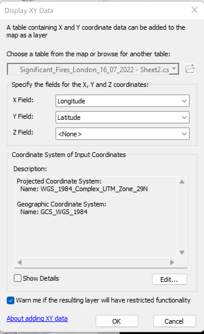
I'm not entirely sure which GCS I am starting with. I open ArcMap, added data from Sentinel (GeoTIFF files) and light grey basemap. I realise that in order for different data sources to be seen together they need to be on same projected coordinate system - is this correct?
I have been doing an online course and reviewing. My understanding is that this table of data has long/lat (which come from a GCS- in degrees) but to put this into ArcMap (2D) I need them to be in a PCS. In order for data to be viewed together from different sources they must be in same PCS and be on one Datum. I can transform projections using the Project tool.
But what I don't know if what PCS I am trying to use!! I think I have got myself in a quite a muddle so any help in best practices are very welcome!
Screenshot is of the Display XY Data when I try and put table of data into the map if that helps?
- Mark as New
- Bookmark
- Subscribe
- Mute
- Subscribe to RSS Feed
- Permalink
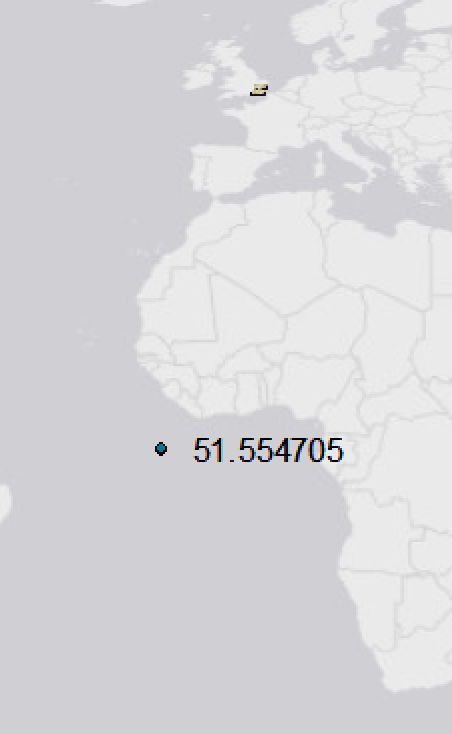
You have the latitudes and longitudes reversed in your table (latitude should be 51°) and what I'm guessing is an incorrect coordinate system. Here's an example of using the first coordinate with your naming convention (test.csv) and with the column names reversed (test1.csv). Your improper coordinate system is probably putting it on the other side of Africa.

- Mark as New
- Bookmark
- Subscribe
- Mute
- Subscribe to RSS Feed
- Permalink
Hi there,
This makes so much sense on getting long/lat the wrong way around. I have tried this and still end up with the same issue but I think it is down to the Projected coordinate system. I am relatively new to arcmap. I have been doing a course online and understand conceptually the difference between Geographic coordinate system (location defined on a 3D surface in degrees - long/lat) and Projected coordinate system (location defined on a 2D surface, which is based off a GCS, measured in coordinates XY) but I haven't yet developed a best practice for how to assess this when bringing in data and where to troubleshoot.
Any help is greatly appreciated as I am very keen to learn this as a foundational practice going forward.
Screenshot is of the Display XY Data when I try and put table of data into the map if that helps?
- Mark as New
- Bookmark
- Subscribe
- Mute
- Subscribe to RSS Feed
- Permalink
You're setting the coordinate system to be UTM, but the coordinates in your file are in lat/long. What happens when you use a geographic projection (WGS84, for example)?
- Mark as New
- Bookmark
- Subscribe
- Mute
- Subscribe to RSS Feed
- Permalink
I tried using different PCS and GCS and nothing was working so I started from scratch as per @RichardHowe suggestion and I am finally making progress!! I feel so stupid as I'm sure these are all obvious to seasoned pros, but I guess we have to start somewhere.
- Mark as New
- Bookmark
- Subscribe
- Mute
- Subscribe to RSS Feed
- Permalink
@Anonymous User
Open a blank ArcMap session, set your coordinate system to "Geographic"> "World"> WGS84 before you start doing anything.
Then add your csv and display xy, picking x as longitude and y as latitude, all just on WGS84
Once they are plotted you can export them as a WGS84 feature class and then worry about re-projecting them
- Mark as New
- Bookmark
- Subscribe
- Mute
- Subscribe to RSS Feed
- Permalink
Hi Richard,
Thank you so much for this as I now finally seem to have these point features in London, UK, rather than Atlantic Ocean!!! Amazing 🙂 This has been two days of experimenting and now I finally feel like I've made some progress. THANK YOU!
What I now have are point features on a basemap in the correct part of the world (screenshot attached)
The map seems kind of squished, which I understand to be due to the type or PCS, is this correct? This would be resolved by using the Project Tool??
What I want to teach myself and understand is best practice for setting up ArcMap when starting a new project. Would you recommend alway starting by setting the Data Frame Properties with "Geographic"> "World"> WGS84?
I fully understand the concept that by using Projected Coordinate Systems eg UTM zones gives better accuracy for a smaller region/country and my understanding is that one can use the Project Tool to change the Projected Coordinate systems of different data layers when working with data after adding the data, but all data needs to be in the same GCS and PCS....Is this correct??
It seems as though by setting the GCS at the start is like I am setting up an invisible XY axis on my screen - is this correct and then once I start putting layers on they sit on top of this invisible axis. Therefore, the invisible (Data Frame Properties) axis must match the same GCS of the data you input otherwise they won't align.
Do I also understand correctly that when adding a csv file with long/lat (done through some geocoding) I need to Display these as XY coordinates in a GCS so they become features/vector data rather than just a table of data (in this case point features) and exist in ArcMap. Or do I need to Export as well as Display XY to turn csv files into actual features/vector data?
Sorry so many questions! But I really want to get my head around this so I have it straight as I know it is the foundation to working in ArcGIS!
Thanks a million in advance
Katy
- Mark as New
- Bookmark
- Subscribe
- Mute
- Subscribe to RSS Feed
- Permalink
You can change the projection of your map window without re-projecting your data. As long as the data has coordinate information attached to it, it can be projected to other coordinate systems on-the-fly. If the data doesn't have coordinate system, you'll want to use the Define Projection tool.
Have you read this information on projections? https://desktop.arcgis.com/en/arcmap/latest/map/projections/what-are-map-projections.htm