- Home
- :
- All Communities
- :
- Products
- :
- ArcMap
- :
- ArcMap Questions
- :
- Shading/hatching a polygon
- Subscribe to RSS Feed
- Mark Topic as New
- Mark Topic as Read
- Float this Topic for Current User
- Bookmark
- Subscribe
- Mute
- Printer Friendly Page
Shading/hatching a polygon
- Mark as New
- Bookmark
- Subscribe
- Mute
- Subscribe to RSS Feed
- Permalink
- Report Inappropriate Content
Hi all, I'm a relatively inexperienced user of ArcMap 10.8.2.
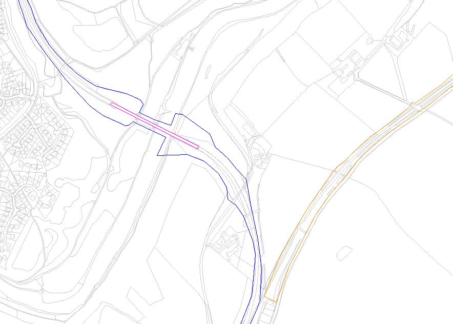
I have created a layer with various polygons drawn on it, and assigned values to different polygons, so the polygons' boundary lines will show in different colours. (See attached)
How do I make these polygons have a 'shading' or 'hatching' inside them, instead of a simple boundary line with no fill? I've looked at all the 'symbols' available, but they only change the boundary lines, there is nothing that provides a 'fill' that I can see?
Thanks for any help!
Solved! Go to Solution.
Accepted Solutions
- Mark as New
- Bookmark
- Subscribe
- Mute
- Subscribe to RSS Feed
- Permalink
- Report Inappropriate Content
Is this for sure a polygon dataset? In the image, it almost looks like lines in which case, symbology would not show a fill option.
R_
- Mark as New
- Bookmark
- Subscribe
- Mute
- Subscribe to RSS Feed
- Permalink
- Report Inappropriate Content
Hello Stephen,
In the Table of Contents, go to the properties of the given layer, and change symbology from "features - Single Symbol" to "Categories". In "Categories", you can change the outline and fill properties. I hope that helps
~ Jeff
- Mark as New
- Bookmark
- Subscribe
- Mute
- Subscribe to RSS Feed
- Permalink
- Report Inappropriate Content
Is this for sure a polygon dataset? In the image, it almost looks like lines in which case, symbology would not show a fill option.
R_
- Mark as New
- Bookmark
- Subscribe
- Mute
- Subscribe to RSS Feed
- Permalink
- Report Inappropriate Content
Thanks for your reply. I created the boundaries as Lines, but then joined the start and end points. I assumed that these would then be Polygons, but it seems not! I've done a little trial and can see that I should have created a Polygon shapefile, that seems to work for having shading and hatching styles available.... I'm now going to have to retrace all my shapes as polygons, unless you know of a way of 'converting' line shapes (or line layers) to Polygon?? Thanks again, Steve
- Mark as New
- Bookmark
- Subscribe
- Mute
- Subscribe to RSS Feed
- Permalink
- Report Inappropriate Content
I assume you have a basic level and not a standard or advanced ArcMap license, as they have tools to do this. A basic level license does not have access to those tools. There is a third party tool called "ETGeowizards" that will do this in their free version. It is a very useful tool, providing access to functionality that is unavailable within ArcMap with a basic level license.
- Jim