- Home
- :
- All Communities
- :
- Products
- :
- ArcMap
- :
- ArcMap Questions
- :
- How do I add points from a shapefile to an already...
- Subscribe to RSS Feed
- Mark Topic as New
- Mark Topic as Read
- Float this Topic for Current User
- Bookmark
- Subscribe
- Mute
- Printer Friendly Page
How do I add points from a shapefile to an already made feature class?
- Mark as New
- Bookmark
- Subscribe
- Mute
- Subscribe to RSS Feed
- Permalink
- Report Inappropriate Content
I am trying to make my job WAAAAY more simple than it is. Hopefully.
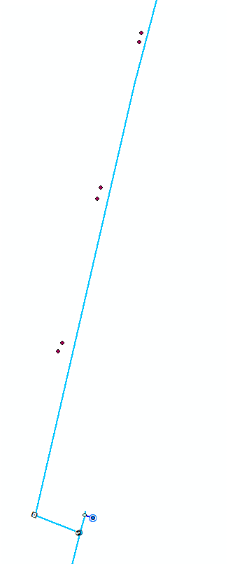
This photo is an example of the situation:

I have a shapefile with many different water meters from out in the field in a subdivision being developed. Near the bottom of the photo, you will see a water meter that has already been added to the database. In the past, I have had to manually make the water meter, then one at a time type in all of the information from the shapefile to the attributes of the new meter I've created.
What I'm hoping for is the ability to basically insert these points inside the shapefile to the water meter feature class inside of the database, automatically moving all of the attributes and stuff so that I don't have to manually type them in. I don't mean a spatial join, because I don't want to make something new. I want to create features without having to create a new feature, just use the points from the shapefile.
If anyone needs me to explain this better, I can. I'm trying my best to not go crazy figuring this one out on my one.
Thanks, y'all!
Solved! Go to Solution.
Accepted Solutions
- Mark as New
- Bookmark
- Subscribe
- Mute
- Subscribe to RSS Feed
- Permalink
- Report Inappropriate Content
Hi @TimG_OWWSB,
You can use the append tool and then set the field map to the following:

It may or may not require editing, but it is recommended to have an edit session open just in case.
- Mark as New
- Bookmark
- Subscribe
- Mute
- Subscribe to RSS Feed
- Permalink
- Report Inappropriate Content
Hi @TimG_OWWSB,
You can use the append tool and then set the field map to the following:
It may or may not require editing, but it is recommended to have an edit session open just in case.
- Mark as New
- Bookmark
- Subscribe
- Mute
- Subscribe to RSS Feed
- Permalink
- Report Inappropriate Content
Thank you so much! You just saved me hours of work.