- Home
- :
- All Communities
- :
- Products
- :
- ArcGIS Web AppBuilder
- :
- ArcGIS Web AppBuilder Questions
- :
- Extent question for Web AppBuilder (Beta) . . .
- Subscribe to RSS Feed
- Mark Topic as New
- Mark Topic as Read
- Float this Topic for Current User
- Bookmark
- Subscribe
- Mute
- Printer Friendly Page
Extent question for Web AppBuilder (Beta) . . .
- Mark as New
- Bookmark
- Subscribe
- Mute
- Subscribe to RSS Feed
- Permalink
I have a .mxd with an extent defined in it.
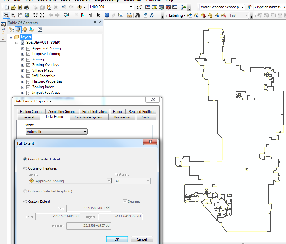
I've published my service. If I use the "Use Web Maps Default Extent" it ignores what I've defined?
I need my focus to be the City of Phoenix only and minimal surrounding cities. How do I achieve this?
Solved! Go to Solution.
Accepted Solutions
- Mark as New
- Bookmark
- Subscribe
- Mute
- Subscribe to RSS Feed
- Permalink
Venus,
It sounds like you are dealing with the standard cached Map LODs limitation. When you use esri basemaps like you are they are restricted to the Levels of Display (LODs) that the map was cached at. So if your desired extent is not the same as one of the LOD scales then the map will automatically zoom to the closest LOD.
- Mark as New
- Bookmark
- Subscribe
- Mute
- Subscribe to RSS Feed
- Permalink
Hello,
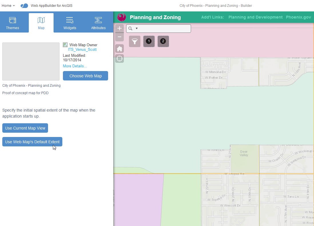
The button "Use Web Map's Default Extent" is designed to use the default extent of the web map that is specified. In the screen shot that you added above it looks like you defined the web map as "City of Phoenix - Planning and Zoning". If you press the button, it should zoom to the default extent for that web map which may not necessarily be the same as the default extent of the service that you published.
At this stage you really would have 2 choices:
1) Update the extent of the web map and then use the "Use Web Map's Default Extent" button.
2) Zoom to your desired area for the default extent of the web app and press the "Use Current Map View" button to make that your apps default extent.
I hope this helps!
Jared G.
- Mark as New
- Bookmark
- Subscribe
- Mute
- Subscribe to RSS Feed
- Permalink
When I try either option, it seems to "force" zoom levels and I either end up with the map cutting off the top and bottom of our city:

The zoom out forces it to an extent that the users says is too far out.
Even when I try the "shift + click and drag" for a more accurate zoom level, it goes to a predefined scale?
Suggestions?
- Mark as New
- Bookmark
- Subscribe
- Mute
- Subscribe to RSS Feed
- Permalink
Venus,
It sounds like you are dealing with the standard cached Map LODs limitation. When you use esri basemaps like you are they are restricted to the Levels of Display (LODs) that the map was cached at. So if your desired extent is not the same as one of the LOD scales then the map will automatically zoom to the closest LOD.
- Mark as New
- Bookmark
- Subscribe
- Mute
- Subscribe to RSS Feed
- Permalink
What you see on the screen is also dependent on the size of the browser. If you have a large screen and maximize it and load your map you get a different result on a smaller browser window. Your extent will adjust based on the viewing area of the browser.
- Mark as New
- Bookmark
- Subscribe
- Mute
- Subscribe to RSS Feed
- Permalink
True enough. Now I just have to convince my customer of this. It should be an easy sell if I remind them of the "mobile" aspect/view of the map.
Thank you!
- Mark as New
- Bookmark
- Subscribe
- Mute
- Subscribe to RSS Feed
- Permalink
Robert. What are my alternatives?
- Mark as New
- Bookmark
- Subscribe
- Mute
- Subscribe to RSS Feed
- Permalink
Venus,
You should choose the next LOD that allows all of your area of interest to be displayed and set that as the maps extent.