- Home
- :
- All Communities
- :
- Products
- :
- ArcGIS Web AppBuilder
- :
- ArcGIS Web AppBuilder Questions
- :
- Attribute Table Widget : Horrible Layer Name Issue...
- Subscribe to RSS Feed
- Mark Topic as New
- Mark Topic as Read
- Float this Topic for Current User
- Bookmark
- Subscribe
- Mute
- Printer Friendly Page
Attribute Table Widget : Horrible Layer Name Issue (Can't Correct)
- Mark as New
- Bookmark
- Subscribe
- Mute
- Subscribe to RSS Feed
- Permalink
So I'm trying to setup a FULL map. I'm having issues with the Attribute Table Widget.
When I initially open the widget I get a series of layer names like so...
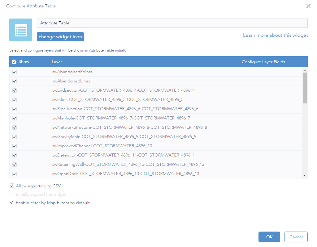
So I went into the config file and adjusted it.
{
  "layerInfos": [{
  "name": "Abandoned: Abandoned Points",
  "id": "COT_STORMWATER_4896_1",
  "layer": {
  "url": "http://maps.cityoftulsa.org/gis/rest/services/Eng/COT_STORMWATER/MapServer/1"
  },
  "show": true
  },
  {
  "name": "Abandoned: Abandoned Lines",
  "id": "COT_STORMWATER_4896_2",
  "layer": {
  "url": "http://maps.cityoftulsa.org/gis/rest/services/Eng/COT_STORMWATER/MapServer/2"
  },
  "show": true
  },
  {
  "name": "Under Construction: Endsection",
  "id": "COT_STORMWATER_4896_4",
  "layer": {
  "url": "http://maps.cityoftulsa.org/gis/rest/services/Eng/COT_STORMWATER/MapServer/4"
  },
  "show": true
  },
  {
  "name": "Under Construction: Inlets",
  "id": "COT_STORMWATER_4896_5",
  "layer": {
  "url": "http://maps.cityoftulsa.org/gis/rest/services/Eng/COT_STORMWATER/MapServer/5"
  },
  "show": true
  },
  {
  "name": "Under Construction: Pipe Junction",
  "id": "COT_STORMWATER_4896_6",
  "layer": {
  "url": "http://maps.cityoftulsa.org/gis/rest/services/Eng/COT_STORMWATER/MapServer/6"
  },
  "show": true
  },
  {
  "name": "Under Construction: Manhole",
  "id": "COT_STORMWATER_4896_7",
  "layer": {
  "url": "http://maps.cityoftulsa.org/gis/rest/services/Eng/COT_STORMWATER/MapServer/7"
  },
  "show": true
  },
  {
  "name": "Under Construction: Network Structure",
  "id": "COT_STORMWATER_4896_8",
  "layer": {
  "url": "http://maps.cityoftulsa.org/gis/rest/services/Eng/COT_STORMWATER/MapServer/8"
  },
  "show": true
  },
  {
  "name": "Under Construction: Gravity Main",
  "id": "COT_STORMWATER_4896_9",
  "layer": {
  "url": "http://maps.cityoftulsa.org/gis/rest/services/Eng/COT_STORMWATER/MapServer/9"
  },
  "show": true
  },
  {
  "name": "Under Construction: Improved Channel",
  "id": "COT_STORMWATER_4896_10",
  "layer": {
  "url": "http://maps.cityoftulsa.org/gis/rest/services/Eng/COT_STORMWATER/MapServer/10"
  },
  "show": true
  },
  {
  "name": "Under Construction: Detention",
  "id": "COT_STORMWATER_4896_11",
  "layer": {
  "url": "http://maps.cityoftulsa.org/gis/rest/services/Eng/COT_STORMWATER/MapServer/11"
  },
  "show": true
  },
  {
  "name": "Under Construction: Retaining Wall",
  "id": "COT_STORMWATER_4896_12",
  "layer": {
  "url": "http://maps.cityoftulsa.org/gis/rest/services/Eng/COT_STORMWATER/MapServer/12"
  },
  "show": true
  },
  {
  "name": "Under Construction: Open Drain",
  "id": "COT_STORMWATER_4896_13",
  "layer": {
  "url": "http://maps.cityoftulsa.org/gis/rest/services/Eng/COT_STORMWATER/MapServer/13"
  },
  "show": true
  },
  {
  "name": "Private: Endsection",
  "id": "COT_STORMWATER_4896_15",
  "layer": {
  "url": "http://maps.cityoftulsa.org/gis/rest/services/Eng/COT_STORMWATER/MapServer/15"
  },
  "show": true
  },
  {
  "name": "Private: Inlets",
  "id": "COT_STORMWATER_4896_16",
  "layer": {
  "url": "http://maps.cityoftulsa.org/gis/rest/services/Eng/COT_STORMWATER/MapServer/16"
  },
  "show": true
  },
  {
  "name": "Private: Pipe Junction",
  "id": "COT_STORMWATER_4896_17",
  "layer": {
  "url": "http://maps.cityoftulsa.org/gis/rest/services/Eng/COT_STORMWATER/MapServer/17"
  },
  "show": true
  },
  {
  "name": "Private: Manhole",
  "id": "COT_STORMWATER_4896_18",
  "layer": {
  "url": "http://maps.cityoftulsa.org/gis/rest/services/Eng/COT_STORMWATER/MapServer/18"
  },
  "show": true
  },
  {
  "name": "Private: Network Structure",
  "id": "COT_STORMWATER_4896_19",
  "layer": {
  "url": "http://maps.cityoftulsa.org/gis/rest/services/Eng/COT_STORMWATER/MapServer/19"
  },
  "show": true
  },
  {
  "name": "Private: Gravity Main",
  "id": "COT_STORMWATER_4896_20",
  "layer": {
  "url": "http://maps.cityoftulsa.org/gis/rest/services/Eng/COT_STORMWATER/MapServer/20"
  },
  "show": true
  },
  {
  "name": "Private: Open Drain",
  "id": "COT_STORMWATER_4896_21",
  "layer": {
  "url": "http://maps.cityoftulsa.org/gis/rest/services/Eng/COT_STORMWATER/MapServer/21"
  },
  "show": true
  },
  {
  "name": "Private: Detention",
  "id": "COT_STORMWATER_4896_22",
  "layer": {
  "url": "http://maps.cityoftulsa.org/gis/rest/services/Eng/COT_STORMWATER/MapServer/22"
  },
  "show": true
  },
  {
  "name": "Private: Retaining Wall",
  "id": "COT_STORMWATER_4896_23",
  "layer": {
  "url": "http://maps.cityoftulsa.org/gis/rest/services/Eng/COT_STORMWATER/MapServer/23"
  },
  "show": true
  },
  {
  "name": "Project Number Text",
  "id": "COT_STORMWATER_4896_25",
  "layer": {
  "url": "http://maps.cityoftulsa.org/gis/rest/services/Eng/COT_STORMWATER/MapServer/25"
  },
  "show": true
  },
  {
  "name": "Remarks Text",
  "id": "COT_STORMWATER_4896_26",
  "layer": {
  "url": "http://maps.cityoftulsa.org/gis/rest/services/Eng/COT_STORMWATER/MapServer/26"
  },
  "show": true
  },
  {
  "name": "City of Tulsa Owned: Endsection",
  "id": "COT_STORMWATER_4896_27",
  "layer": {
  "url": "http://maps.cityoftulsa.org/gis/rest/services/Eng/COT_STORMWATER/MapServer/27"
  },
  "show": true
  },
  {
  "name": "City of Tulsa Owned: Inlets",
  "id": "COT_STORMWATER_4896_28",
  "layer": {
  "url": "http://maps.cityoftulsa.org/gis/rest/services/Eng/COT_STORMWATER/MapServer/28"
  },
  "show": true
  },
  {
  "name": "City of Tulsa Owned: Pipe Junction",
  "id": "COT_STORMWATER_4896_29",
  "layer": {
  "url": "http://maps.cityoftulsa.org/gis/rest/services/Eng/COT_STORMWATER/MapServer/29"
  },
  "show": true
  },
  {
  "name": "City of Tulsa Owned: Manhole",
  "id": "COT_STORMWATER_4896_30",
  "layer": {
  "url": "http://maps.cityoftulsa.org/gis/rest/services/Eng/COT_STORMWATER/MapServer/30"
  },
  "show": true
  },
  {
  "name": "City of Tulsa Owned: Network Structure",
  "id": "COT_STORMWATER_4896_31",
  "layer": {
  "url": "http://maps.cityoftulsa.org/gis/rest/services/Eng/COT_STORMWATER/MapServer/31"
  },
  "show": true
  },
  {
  "name": "City of Tulsa Owned: Gravity Main",
  "id": "COT_STORMWATER_4896_32",
  "layer": {
  "url": "http://maps.cityoftulsa.org/gis/rest/services/Eng/COT_STORMWATER/MapServer/32"
  },
  "show": true
  },
  {
  "name": "City of Tulsa Owned: Improved Channel",
  "id": "COT_STORMWATER_4896_33",
  "layer": {
  "url": "http://maps.cityoftulsa.org/gis/rest/services/Eng/COT_STORMWATER/MapServer/33"
  },
  "show": true
  },
  {
  "name": "City of Tulsa Owned: Detention",
  "id": "COT_STORMWATER_4896_34",
  "layer": {
  "url": "http://maps.cityoftulsa.org/gis/rest/services/Eng/COT_STORMWATER/MapServer/34"
  },
  "show": true
  },
  {
  "name": "City of Tulsa Owned: Detention Facility Access",
  "id": "COT_STORMWATER_4896_35",
  "layer": {
  "url": "http://maps.cityoftulsa.org/gis/rest/services/Eng/COT_STORMWATER/MapServer/35"
  },
  "show": true
  },
  {
  "name": "City of Tulsa Owned: Retaining Wall",
  "id": "COT_STORMWATER_4896_36",
  "layer": {
  "url": "http://maps.cityoftulsa.org/gis/rest/services/Eng/COT_STORMWATER/MapServer/36"
  },
  "show": true
  },
  {
  "name": "City of Tulsa Owned: Open Drain",
  "id": "COT_STORMWATER_4896_37",
  "layer": {
  "url": "http://maps.cityoftulsa.org/gis/rest/services/Eng/COT_STORMWATER/MapServer/37"
  },
  "show": true
  },
  {
  "name": "City of Tulsa Owned: Drainage Basin",
  "id": "COT_STORMWATER_4896_38",
  "layer": {
  "url": "http://maps.cityoftulsa.org/gis/rest/services/Eng/COT_STORMWATER/MapServer/38"
  },
  "show": true
  },
  {
  "name": "City of Tulsa Owned: Levee",
  "id": "COT_STORMWATER_4896_39",
  "layer": {
  "url": "http://maps.cityoftulsa.org/gis/rest/services/Eng/COT_STORMWATER/MapServer/39"
  },
  "show": true
  },
  {
  "name": "City of Tulsa Owned: Bridge",
  "id": "COT_STORMWATER_4896_40",
  "layer": {
  "url": "http://maps.cityoftulsa.org/gis/rest/services/Eng/COT_STORMWATER/MapServer/40"
  },
  "show": true
  },
  {
  "name": "City of Tulsa Owned: Waterline",
  "id": "COT_STORMWATER_4896_41",
  "layer": {
  "url": "http://maps.cityoftulsa.org/gis/rest/services/Eng/COT_STORMWATER/MapServer/41"
  },
  "show": true
  },
  {
  "name": "City of Tulsa Owned: Waterbody",
  "id": "COT_STORMWATER_4896_42",
  "layer": {
  "url": "http://maps.cityoftulsa.org/gis/rest/services/Eng/COT_STORMWATER/MapServer/42"
  },
  "show": true
  }],
  "table": {
  "pageSizeOptions": [25,
  50,
  100,
  1000]
  },
  "hideExportButton": false,
  "initiallyExpand": false,
  "filterByMapExtent": true
}
and it doesn't stick. I can CLOSE the WAB. Edit the config file. And when I open the WAB and that app I still get the messed up layer names.
Any suggestions?
Solved! Go to Solution.
Accepted Solutions
- Mark as New
- Bookmark
- Subscribe
- Mute
- Subscribe to RSS Feed
- Permalink
I couldn't figure it out so I went back to the MXD and renamed each layer with a completely unique layer name. Apparently, the layers sharing a similar name (regardless of the grouping they may/may not be in) didn't matter.
swInlet under Private lines was treated a duplicated of swInlet under City owned lines.