- Home
- :
- All Communities
- :
- Products
- :
- ArcGIS Web AppBuilder
- :
- ArcGIS Web AppBuilder Questions
- :
- Accessing Map from Widget code
- Subscribe to RSS Feed
- Mark Topic as New
- Mark Topic as Read
- Float this Topic for Current User
- Bookmark
- Subscribe
- Mute
- Printer Friendly Page
- Mark as New
- Bookmark
- Subscribe
- Mute
- Subscribe to RSS Feed
- Permalink
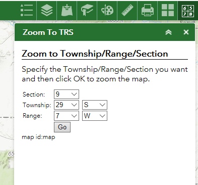
I'm likely making a stupid mistake but right now I'm not seeing it. I'm getting my feet wet with WAB Developer Edition 2.8 and I'm making a simple widget (based on demo widget template in the samplewidgets folder). In my widget, the user specifies a township/range/section and the map zooms to that location. Here's the widget:

Simple stuff. My code works up to the point of updating the map extent. I get an error that the "Object doesn't support property or method 'setExtent'". From my search, I feel like I'm referencing the map the right way but clearly I'm not. What am I missing?
There's not much to it but here's my widget.js code:
define(['dojo/_base/declare', 'dojo/dom', 'dojo/on', 'esri/tasks/query', 'esri/tasks/QueryTask', 'jimu/BaseWidget'],
function(declare, dom, on, Query, QueryTask, BaseWidget) {
//To create a widget, you need to derive from BaseWidget.
return declare([BaseWidget], {
// DemoWidget code goes here
//please note that this property is be set by the framework when widget is loaded.
//templateString: template,
baseClass: 'jimu-widget-demo',
postCreate: function() {
this.inherited(arguments);
//console.log('postCreate');
},
startup: function() {
this.inherited(arguments);
this.mapIdNode.innerHTML = 'map id:' + this.map.id;
on(dom.byId("zoomButton"), "click", function() {
var queryString = "Township=" + dom.byId('townshipNum').value + " AND TWP_CHAR='" + dom.byId('townshipDir').value + "' AND RANGE=" + dom.byId('rangeNum').value;
queryString = queryString + " AND RNG_CHAR='" +dom.byId('rangeDir').value + "' AND SECTION=" + dom.byId('sectionNum').value;
var query = new Query();
query.returnGeometry = true;
query.where = queryString;
var qTask = new QueryTask("https://navigator.state.or.us/arcgis/rest/services/Framework/Cadastral_PLSS_WM/MapServer/3");
qTask.execute(query, function(results) {
if (results.features.length != 1) {
alert('There was an issue zooming into your Township/Range/Section.');
} else {
var plssGeom = results.features[0].geometry;
this.map.setExtent(plssGeom.getExtent());
}
});
});
},
onOpen: function(){
//console.log('onOpen');
},
onClose: function(){
//console.log('onClose');
},
onMinimize: function(){
//console.log('onMinimize');
},
onMaximize: function(){
//console.log('onMaximize');
}
});
});The error happens on line 35 in my code above. Should my code be in a different event function instead of startup?
Thanks!
Steve
Solved! Go to Solution.
Accepted Solutions
- Mark as New
- Bookmark
- Subscribe
- Mute
- Subscribe to RSS Feed
- Permalink
Steve,
The scope of “this” inside of your query task function is different from the scope outside of that function. To maintain the scope you must use lang.hitch or a closure.
startup: function() {
this.inherited(arguments);
this.mapIdNode.innerHTML = 'map id:' + this.map.id;
on(dom.byId("zoomButton"), "click", lang.hitch(this, function() {
var queryString = "Township=" + dom.byId('townshipNum').value + " AND TWP_CHAR='" + dom.byId('townshipDir').value + "' AND RANGE=" + dom.byId('rangeNum').value;
queryString = queryString + " AND RNG_CHAR='" +dom.byId('rangeDir').value + "' AND SECTION=" + dom.byId('sectionNum').value;
var query = new Query();
query.returnGeometry = true;
query.where = queryString;
var qTask = new QueryTask("https://navigator.state.or.us/arcgis/rest/services/Framework/Cadastral_PLSS_WM/MapServer/3");
qTask.execute(query, lang.hitch(this, function(results) {
if (results.features.length != 1) {
alert('There was an issue zooming into your Township/Range/Section.');
} else {
var plssGeom = results.features[0].geometry;
this.map.setExtent(plssGeom.getExtent());
}
}));
}));
},- Mark as New
- Bookmark
- Subscribe
- Mute
- Subscribe to RSS Feed
- Permalink
Thanks, Robert. I'll give this a try tonight. I figured I was doing something stupid!