Turn on suggestions
Auto-suggest helps you quickly narrow down your search results by suggesting possible matches as you type.
Cancel
- Home
- :
- All Communities
- :
- Products
- :
- ArcGIS Viewer for Flex (Retired)
- :
- ArcGIS Viewer for Flex Questions
- :
- The window ???zoom in???and ???zoom out??? are mis...
Options
- Subscribe to RSS Feed
- Mark Topic as New
- Mark Topic as Read
- Float this Topic for Current User
- Bookmark
- Subscribe
- Mute
- Printer Friendly Page
The window ???zoom in???and ???zoom out??? are missed in the ???map extent??? mode,
Subscribe
12-27-2012
10:04 PM
- Mark as New
- Bookmark
- Subscribe
- Mute
- Subscribe to RSS Feed
- Permalink
The window ???zoom in???and ???zoom out??? are missed in the ???map extent??? mode,
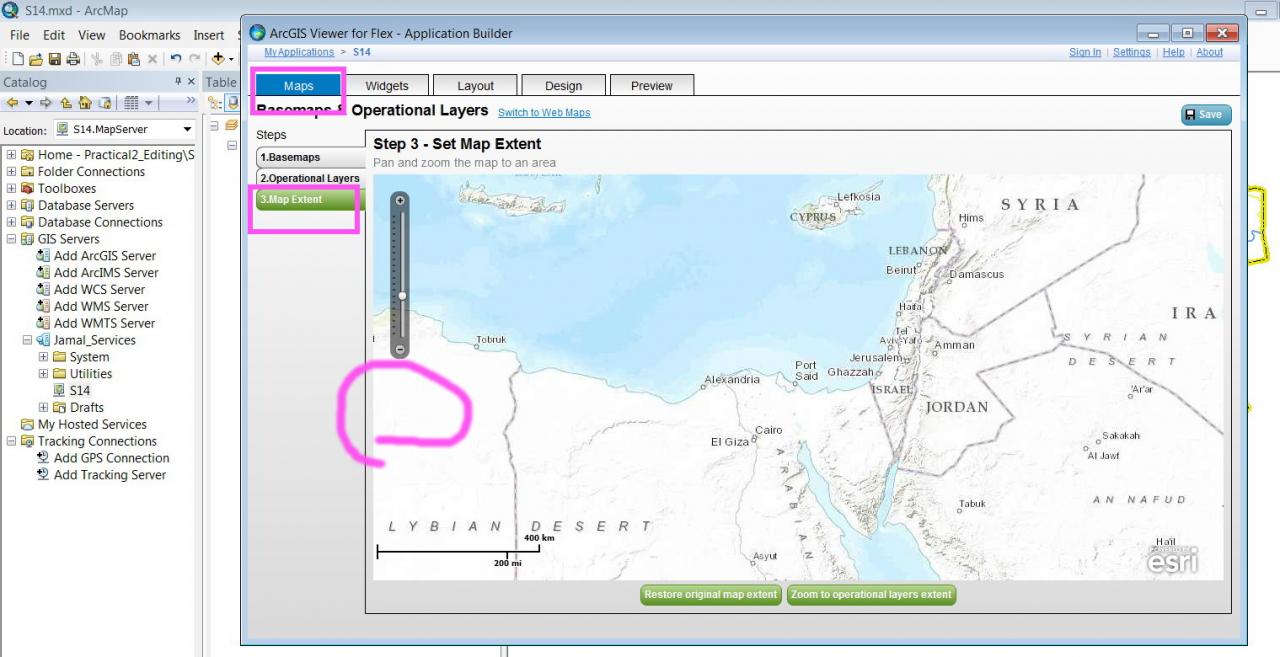
Please, have a look in the screenshot below.
[ATTACH=CONFIG]20236[/ATTACH]
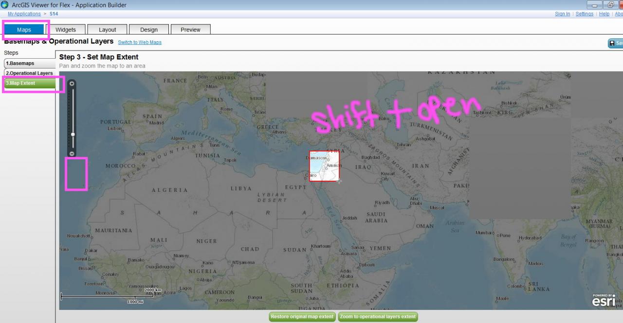
Here the ???zoom in??? and ???zoom out??? are provided which enables window zooming at the target area. While these two tools are missed in the ???map extent??? mode!
[ATTACH=CONFIG]20237[/ATTACH]
What might be the reason?
Thank you
Best
Jamal
Please, have a look in the screenshot below.
[ATTACH=CONFIG]20236[/ATTACH]
Here the ???zoom in??? and ???zoom out??? are provided which enables window zooming at the target area. While these two tools are missed in the ???map extent??? mode!
[ATTACH=CONFIG]20237[/ATTACH]
What might be the reason?
Thank you
Best
Jamal
----------------------------------------
Jamal Numan
Geomolg Geoportal for Spatial Information
Ramallah, West Bank, Palestine
Jamal Numan
Geomolg Geoportal for Spatial Information
Ramallah, West Bank, Palestine
Solved! Go to Solution.
1 Solution
Accepted Solutions
by
Anonymous User
Not applicable
12-27-2012
10:20 PM
- Mark as New
- Bookmark
- Subscribe
- Mute
- Subscribe to RSS Feed
- Permalink
Original User: Law
Hi Jamal,
This is correct and by design. In the first screen capture you provided, it shows the Preview tab of the ArcGIS Viewer for Flex application builder, which shows the navigation widget.
In the second screen capture you provided, it shows the Maps tab - which is not meant to display the navigation widget. You can still define a spatial extent bounding box on the tab by simply holding down the Shift key as you left mouse click to zoom in/out.
Hope this helps,
Hi Jamal,
The window ???zoom in??? and ???zoom out??? are missed in the ???map extent??? mode ...
This is correct and by design. In the first screen capture you provided, it shows the Preview tab of the ArcGIS Viewer for Flex application builder, which shows the navigation widget.
In the second screen capture you provided, it shows the Maps tab - which is not meant to display the navigation widget. You can still define a spatial extent bounding box on the tab by simply holding down the Shift key as you left mouse click to zoom in/out.
Hope this helps,
2 Replies
by
Anonymous User
Not applicable
12-27-2012
10:20 PM
- Mark as New
- Bookmark
- Subscribe
- Mute
- Subscribe to RSS Feed
- Permalink
Original User: Law
Hi Jamal,
This is correct and by design. In the first screen capture you provided, it shows the Preview tab of the ArcGIS Viewer for Flex application builder, which shows the navigation widget.
In the second screen capture you provided, it shows the Maps tab - which is not meant to display the navigation widget. You can still define a spatial extent bounding box on the tab by simply holding down the Shift key as you left mouse click to zoom in/out.
Hope this helps,
Hi Jamal,
The window ???zoom in??? and ???zoom out??? are missed in the ???map extent??? mode ...
This is correct and by design. In the first screen capture you provided, it shows the Preview tab of the ArcGIS Viewer for Flex application builder, which shows the navigation widget.
In the second screen capture you provided, it shows the Maps tab - which is not meant to display the navigation widget. You can still define a spatial extent bounding box on the tab by simply holding down the Shift key as you left mouse click to zoom in/out.
Hope this helps,
12-28-2012
01:42 AM
- Mark as New
- Bookmark
- Subscribe
- Mute
- Subscribe to RSS Feed
- Permalink
Hi Jamal,
This is correct and by design. In the first screen capture you provided, it shows the Preview tab of the ArcGIS Viewer for Flex application builder, which shows the navigation widget.
In the second screen capture you provided, it shows the Maps tab - which is not meant to display the navigation widget. You can still define a spatial extent bounding box on the tab by simply holding down the Shift key as you left mouse click to zoom in/out.
Hope this helps,
Thank you for the help Derek. This is very useful.
[ATTACH=CONFIG]20248[/ATTACH]
Best
Jamal
----------------------------------------
Jamal Numan
Geomolg Geoportal for Spatial Information
Ramallah, West Bank, Palestine
Jamal Numan
Geomolg Geoportal for Spatial Information
Ramallah, West Bank, Palestine