Turn on suggestions
Auto-suggest helps you quickly narrow down your search results by suggesting possible matches as you type.
Cancel
- Home
- :
- All Communities
- :
- Products
- :
- ArcGIS Viewer for Flex (Retired)
- :
- ArcGIS Viewer for Flex Questions
- :
- Print/Export offsets Layers
Options
- Subscribe to RSS Feed
- Mark Topic as New
- Mark Topic as Read
- Float this Topic for Current User
- Bookmark
- Subscribe
- Mute
- Printer Friendly Page
Print/Export offsets Layers
Subscribe
2448
4
01-06-2014 05:09 AM
by
Anonymous User
Not applicable
01-06-2014
05:09 AM
- Mark as New
- Bookmark
- Subscribe
- Mute
- Subscribe to RSS Feed
- Permalink
Original User: cblinnmrc
Hello All,
FlexViewer 3.0
AGS 10 SP5
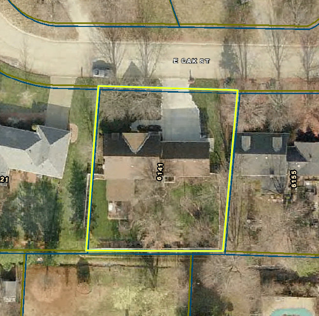
I am having a peculiar issue with the Print/Export from my flexviewer website. After the PDF, PNG, or JPG is exported and ready to print, the layers appear to be offset.
On the website and in the MXD that the dynamic service is created from, my layers appear correctly.
Here is an example, the first image showing how it appears on the website/MXD (correct):
[ATTACH=CONFIG]30279[/ATTACH]
The next image showing the offset of the layers (incorrect):
[ATTACH=CONFIG]30280[/ATTACH]
Each layer has the same projection (which shouldn't matter since they are hosted as a dynamic service).
Any insight is appreciated.
Thanks,
Chris B.
Hello All,
FlexViewer 3.0
AGS 10 SP5
I am having a peculiar issue with the Print/Export from my flexviewer website. After the PDF, PNG, or JPG is exported and ready to print, the layers appear to be offset.
On the website and in the MXD that the dynamic service is created from, my layers appear correctly.
Here is an example, the first image showing how it appears on the website/MXD (correct):
[ATTACH=CONFIG]30279[/ATTACH]
The next image showing the offset of the layers (incorrect):
[ATTACH=CONFIG]30280[/ATTACH]
Each layer has the same projection (which shouldn't matter since they are hosted as a dynamic service).
Any insight is appreciated.
Thanks,
Chris B.
4 Replies
01-07-2014
06:27 AM
- Mark as New
- Bookmark
- Subscribe
- Mute
- Subscribe to RSS Feed
- Permalink
It looks as though your parcel layer gets duplicated on the print as there are two sets of outlines showing. Is that layer in your service multiple times?
I'm seeing a similar issue here (in 3.6, but wasn't there in 3.0) where the labels that are drawn with my parcels layer are getting duplicated on the print. I have that one layer in my service multiple times however (in order to allow users to turn on different labels) and I was thinking that may contribute to the issue. If you do or do not have that layer there multiple times it may help to narrow down the issue. It sure looks like a bug though.
I'm seeing a similar issue here (in 3.6, but wasn't there in 3.0) where the labels that are drawn with my parcels layer are getting duplicated on the print. I have that one layer in my service multiple times however (in order to allow users to turn on different labels) and I was thinking that may contribute to the issue. If you do or do not have that layer there multiple times it may help to narrow down the issue. It sure looks like a bug though.
by
Anonymous User
Not applicable
01-07-2014
10:42 AM
- Mark as New
- Bookmark
- Subscribe
- Mute
- Subscribe to RSS Feed
- Permalink
Original User: cblinnmrc
Eric,
Thank you for your response.
The layer is not duplicated, it is in fact two different layers. One being current taxed parcels, another being current property boundaries (very similar, but different nonetheless).
I am at a loss on what might be causing the issue. I take it the lack of responses means one of two possibilities, 1. the issue is a bug, or 2. there is no issue, this is expected behavior of the widget and I need to get over it.
Anyways, that is where I am at right now. It's not a major deal, but there are cases where end users have both taxed parcels, and property boundaries turned on (to show a merge or split or property in most cases), and the boundaries that did not change appear to be different. What makes it worse is those stakeholders usually need extremely accurate portrayals of the data, and this widget is making the data appear inaccurate, when it's not.
-Chris B.
01-07-2014
11:21 AM
- Mark as New
- Bookmark
- Subscribe
- Mute
- Subscribe to RSS Feed
- Permalink
This isn't much help but in my map service I have the same layer (parcels) in it twice and when I turn them both on at the same time, I do not see the same issue you do.
Does this happen when you do not select anything? When you remove other layers? Might help narrow down the culprit.
Does this happen when you do not select anything? When you remove other layers? Might help narrow down the culprit.
by
Anonymous User
Not applicable
01-07-2014
11:30 AM
- Mark as New
- Bookmark
- Subscribe
- Mute
- Subscribe to RSS Feed
- Permalink
Original User: cblinnmrc
The issue still occurs when:
Like I said, I am stumped.
The issue still occurs when:
- With/Without Selection
- Other Layers On/Off
- Print Settings force scale/not force scale
- In ALL formats available in Print Tool
Like I said, I am stumped.