Turn on suggestions
Auto-suggest helps you quickly narrow down your search results by suggesting possible matches as you type.
Cancel
- Home
- :
- All Communities
- :
- Products
- :
- ArcGIS Viewer for Flex (Retired)
- :
- ArcGIS Viewer for Flex Questions
- :
- Re: Enhanced-Search-Widget-for-FlexViewer Part III
Options
- Subscribe to RSS Feed
- Mark Topic as New
- Mark Topic as Read
- Float this Topic for Current User
- Bookmark
- Subscribe
- Mute
- Printer Friendly Page
Enhanced-Search-Widget-for-FlexViewer Part III
Subscribe
116221
776
04-30-2013 03:58 PM
04-30-2013
03:58 PM
- Mark as New
- Bookmark
- Subscribe
- Mute
- Subscribe to RSS Feed
- Permalink
- Report Inappropriate Content
All,
Here is a new thread to post questions and discuss the Enhanched Search Widget. The old thread was getting too long.
Here is a new thread to post questions and discuss the Enhanched Search Widget. The old thread was getting too long.
776 Replies
10-28-2013
06:03 AM
- Mark as New
- Bookmark
- Subscribe
- Mute
- Subscribe to RSS Feed
- Permalink
- Report Inappropriate Content
Jay,
Glad you got it resolved. I hate having to say I could not help in that senario.
Glad you got it resolved. I hate having to say I could not help in that senario.
10-28-2013
12:11 PM
- Mark as New
- Bookmark
- Subscribe
- Mute
- Subscribe to RSS Feed
- Permalink
- Report Inappropriate Content
Robert,
I cannot seem to figure out how to get the results to appear in a table. The search executes correctly and I can click on the results tab in the search window to see a list of results, but I cannot figure out how to get the results to appear in a separate table. I have checked and double checked my code in both my main config.xml file and my eSearchWidget.xml file. Can you please point me into the right direction?
Thanks,
Kirsten
10-28-2013
01:37 PM
- Mark as New
- Bookmark
- Subscribe
- Mute
- Subscribe to RSS Feed
- Permalink
- Report Inappropriate Content
Kirsten,
If you look at the example eSearchWidget.xml that comes in the download or read the configuration pdf you will see that for a field to appear in the table you need to define that that field is a gridfield by using the gridfield="true" attribute on a field. If you use the
If you look at the example eSearchWidget.xml that comes in the download or read the configuration pdf you will see that for a field to appear in the table you need to define that that field is a gridfield by using the gridfield="true" attribute on a field. If you use the
<fields all="true">then you do not have this option.
10-30-2013
02:14 PM
- Mark as New
- Bookmark
- Subscribe
- Mute
- Subscribe to RSS Feed
- Permalink
- Report Inappropriate Content
Hi Robert,
Hope this message finds you well.
I'm experiencing a problem with eSearch3.5.3 in SFV3.5. The search layer and search field pick list labels are missing. It happens with or without preload. It occurs on both my customized esearch.xml and the OTB esearch.xml. I saw a previous message about this problem being fixed at 3.5.3. I downloaded and tested es3.5.3 from both esri and github. Have I missed something? Appreciate any help.
[ATTACH=CONFIG]28737[/ATTACH]
Much thanks from this SVF junkie for all over your amazing work over the years!
Ned Cake
TLCGIS
10-30-2013
07:17 PM
- Mark as New
- Bookmark
- Subscribe
- Mute
- Subscribe to RSS Feed
- Permalink
- Report Inappropriate Content
Ned,
Actually the fix for what you are seeing will not be out untill the next release. But there is a simple workaround for this isse in 3.5.3. All you need to do is add a with attribute to the widget tag in the main config:
Actually the fix for what you are seeing will not be out untill the next release. But there is a simple workaround for this isse in 3.5.3. All you need to do is add a with attribute to the widget tag in the main config:
width="400"
10-31-2013
04:45 AM
- Mark as New
- Bookmark
- Subscribe
- Mute
- Subscribe to RSS Feed
- Permalink
- Report Inappropriate Content
Thanks Robert! That did the trick...
Ned
Ned
Ned,
Actually the fix for what you are seeing will not be out untill the next release. But there is a simple workaround for this isse in 3.5.3. All you need to do is add a with attribute to the widget tag in the main config:width="400"
11-01-2013
11:58 AM
- Mark as New
- Bookmark
- Subscribe
- Mute
- Subscribe to RSS Feed
- Permalink
- Report Inappropriate Content
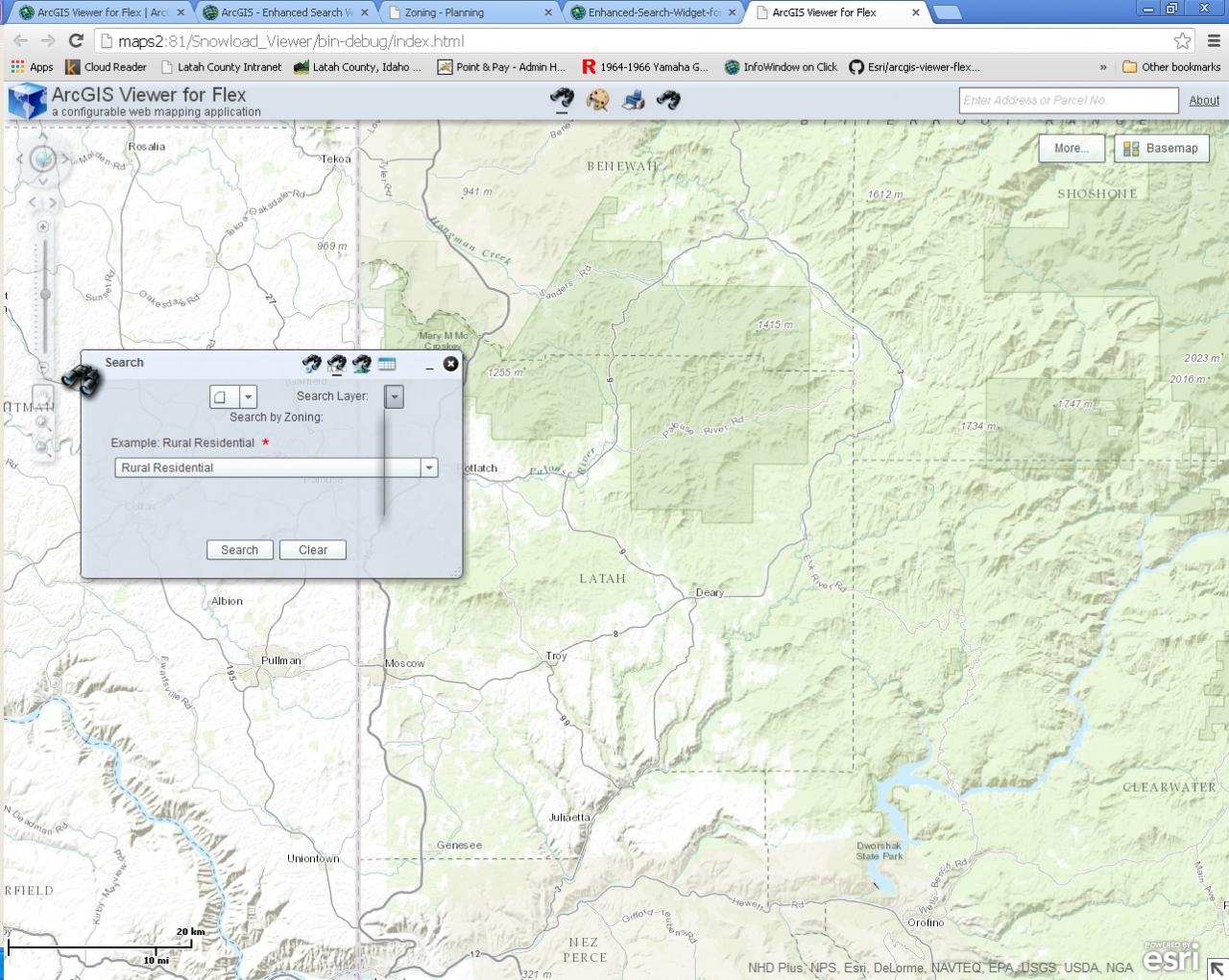
Hi There Again. Still Very new to this stuff, so I apologize in advance if my questions have previously been answered else where.
I have recently downloaded the esearch widget (uncompiled) and added it to my project in Adobe Flash Builder 4.7. I am using the api for flex 3.5, flex sdk 4.6, and esearch widget 3.5.3.
I have added the esearch to widgets, added the mxml files to my flex modules list, and added the images to src.assets.images.
I have configured the following bit of the eSearchWidget.xml, defining searches on two different layers of the same mapservice (I
think)
<layer>
<token/>
<definitionexpression></definitionexpression>
<enableexport>true</enableexport>
<name>Zoning</name>
<url>http://*************/rest/services/Planning/MapServer/4</url>
<expressions>
<expression alias="Zoning" textsearchlabel="Search by Zoning:" isvaluerequired="true">
<values>
<value prompt="Example: Rural Residential" userlist="Rural Residential,Commercial,Motor Business,
Multiple Family Residential,Municipality,Single-Family Residential,Single-Family Residential (R-1),
Suburban Residential" isvaluerequired="true" autosubmit="false" operator="AND">
upper(ZONE_TYPE) LIKE upper('%[value]%')</value>
</values>
</expression>
</expressions>
<graphicalsearchlabel>Use one of the graphical search tools to select Zoning</graphicalsearchlabel>
<spatialsearchlayer>false</spatialsearchlayer>
<titlefield>ZONING_TYPE</titlefield>
<fields all="true" />
<links/>
<zoomscale usegeometry="true" zoompercent="2"></zoomscale>
<autoopendatagrid>false</autoopendatagrid>
<queryattachments>false</queryattachments>
<relates/>
<symbology>
<simplefillsymbol color="0xff0000" alpha="0.5">
<outline color="0xff0000" alpha="0.8" width="2" />
</simplefillsymbol>
</symbology>
</layer>
<layer>
<token/>
<definitionexpression></definitionexpression>
<enableexport>false</enableexport>
<enableprintgrid title="Building Permits">true</enableprintgrid>
<name>Building Permits</name>
<url>http://***************/rest/services/Planning/MapServer/0</url>
<expressions>
<expression alias="Building Permit" textsearchlabel="Search Permits by Permit Number">
<values>
<value prompt="Example: 2009-053" isvaluerequired="true" autosubmit="false">PERMIT_ = '[value]'</value>
</values>
</expression>
</expressions>
<graphicalsearchlabel>Use one of the graphical search tools to select Building Permits</graphicalsearchlabel>
<spatialsearchlayer>false</spatialsearchlayer>
<titlefield>PERMIT_</titlefield>
<fields all="true" />
<links/>
<zoomscale usegeometry="true" zoompercent="2"></zoomscale>
<autoopendatagrid>false</autoopendatagrid>
<queryattachments>false</queryattachments>
<symbology>
<simplemarkersymbol/>
</symbology>
</layer>
The problem that I am having, is that only the first search appears in the eSearch widget when run, and the "layer" button drop down menu on the widget doesn't work. (Clicking on the Layer button produces a vertical line on the widget)
Any ideas on what I may be doing wrong here?
Thanks in advance.
-James
11-01-2013
12:14 PM
- Mark as New
- Bookmark
- Subscribe
- Mute
- Subscribe to RSS Feed
- Permalink
- Report Inappropriate Content
James,
This is a know issue in version 3.5.3 of the eSearch widget when you do not have a width attribute in the widget tag in your main config.xml.
So just add
This is a know issue in version 3.5.3 of the eSearch widget when you do not have a width attribute in the widget tag in your main config.xml.
So just add
<widget label="Enhanced Search" left="80" top="100" preload="open"
                icon="assets/images/i_search.png" width="400"
                config="widgets/eSearch/eSearchWidget.xml"
                url="widgets/eSearch/eSearchWidget.swf"/>
11-01-2013
12:27 PM
- Mark as New
- Bookmark
- Subscribe
- Mute
- Subscribe to RSS Feed
- Permalink
- Report Inappropriate Content
That did it, Thanks again!
-James
-James
11-03-2013
04:54 AM
- Mark as New
- Bookmark
- Subscribe
- Mute
- Subscribe to RSS Feed
- Permalink
- Report Inappropriate Content
Hello Robert,
I have developed a geoprocessing widget that creates a buffer around polyline segments, then clips features from one point and one polygon layer within the aforementioned buffer area. The clipped features, from the point and polygon layers, are added to the mapping application as operational layers.
Is it possible to configure the Enhanced Search Widget to search the geoprocessing results of the two layers that have been added to the mapping application as operational layers?
Thank you for your assistance.