Turn on suggestions
Auto-suggest helps you quickly narrow down your search results by suggesting possible matches as you type.
Cancel
- Home
- :
- All Communities
- :
- Products
- :
- ArcGIS Viewer for Flex (Retired)
- :
- ArcGIS Viewer for Flex Questions
- :
- Enhanced Draw Widget Functionality
Options
- Subscribe to RSS Feed
- Mark Topic as New
- Mark Topic as Read
- Float this Topic for Current User
- Bookmark
- Subscribe
- Mute
- Printer Friendly Page
02-01-2013
05:15 AM
- Mark as New
- Bookmark
- Subscribe
- Mute
- Subscribe to RSS Feed
- Permalink
Robert,
I was curious if you had any plans to incorporate the real time measurment functionality that is in the standard draw widget at 3.1 into your enhanced widget. I prefer your enhanced version, and it will continue to be my go to draw widget, but would love to see the real time functionality in the future if possible.
Thanks for all of the work you put into these widgets! They are great!
Justin
Solved! Go to Solution.
33 Replies
01-30-2014
04:51 AM
- Mark as New
- Bookmark
- Subscribe
- Mute
- Subscribe to RSS Feed
- Permalink
Aaron,
Sure to show measuring as checked at widget startup just add the <measure>true</measure> (covered in the OTB Draw widget doc). To set Feet as default just put 'ft' at the top of the distanceunits list in the XML, same for 'ac'.
You need to also add these width and height tags to the eDrawWidget in the main config.xml
width="530" height="335"
02-06-2014
10:32 AM
- Mark as New
- Bookmark
- Subscribe
- Mute
- Subscribe to RSS Feed
- Permalink
Robert,
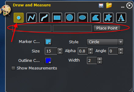
Continuing on in this Enhanced Draw Widget Functionality thread - In the 3.5 version there is a 'place point' option when the point graphic is selected. I don't see it in the 3.6 version - was it removed on purpose or am I not seeing what I should?
Thanks in advance,
~ D
Continuing on in this Enhanced Draw Widget Functionality thread - In the 3.5 version there is a 'place point' option when the point graphic is selected. I don't see it in the 3.6 version - was it removed on purpose or am I not seeing what I should?
Thanks in advance,
~ D
02-06-2014
10:54 AM
- Mark as New
- Bookmark
- Subscribe
- Mute
- Subscribe to RSS Feed
- Permalink
Daniel,
That was experimental stuff I NEVER meant to let out in version 3.5.
That was experimental stuff I NEVER meant to let out in version 3.5.
02-06-2014
11:29 AM
- Mark as New
- Bookmark
- Subscribe
- Mute
- Subscribe to RSS Feed
- Permalink
Robert,
Damn! That's too bad, it works great as long as you know the map units. Any chance you may revisit that functionality and make it work?
And man am I glad I asked. I was starting to get tangled up in that code trying to make it work differently. Thanks for responding!
~ D
Damn! That's too bad, it works great as long as you know the map units. Any chance you may revisit that functionality and make it work?
And man am I glad I asked. I was starting to get tangled up in that code trying to make it work differently. Thanks for responding!
~ D
02-06-2014
11:45 AM
- Mark as New
- Bookmark
- Subscribe
- Mute
- Subscribe to RSS Feed
- Permalink
Daniel,
It is something I am considering (that is why it accidentally got out). But I have a long way to go yet as once I add this feature I will likely have to support a few different coordinate input formats and figure out how to handle manual entry for polygon and poly lines. You can easily add back what I let slip out if you are using the source code, by comparing 3.5 to 3.6.
It is something I am considering (that is why it accidentally got out). But I have a long way to go yet as once I add this feature I will likely have to support a few different coordinate input formats and figure out how to handle manual entry for polygon and poly lines. You can easily add back what I let slip out if you are using the source code, by comparing 3.5 to 3.6.
02-06-2014
11:55 AM
- Mark as New
- Bookmark
- Subscribe
- Mute
- Subscribe to RSS Feed
- Permalink
Ah, but therein lies the rub - I'm still using the 3.5 version, so the 'place point' ability is in there, but I'm stuck as I wanted to give my users the ability to place a point by decimal degrees (just like you said where you would have to support a few different coordinate input formats ) and making that work is beyond my skill set. I'm stuck specifically on converting the map units to DD and then making the tool plot the point correctly instead of at 0,0.
Thanks again for all your work and help,
~ D
Thanks again for all your work and help,
~ D
02-06-2014
12:09 PM
- Mark as New
- Bookmark
- Subscribe
- Mute
- Subscribe to RSS Feed
- Permalink
Daniel,
Ahh. So you are one of my case in point situations then... I can not release something without trying to consider what MORE people will want from the new feature and weight the development cost with the potential usage of the feature (I gauge these things by listening to the forums and seeing what functionality people are talking about wanting in widgets).
Ahh. So you are one of my case in point situations then... I can not release something without trying to consider what MORE people will want from the new feature and weight the development cost with the potential usage of the feature (I gauge these things by listening to the forums and seeing what functionality people are talking about wanting in widgets).
02-06-2014
12:13 PM
- Mark as New
- Bookmark
- Subscribe
- Mute
- Subscribe to RSS Feed
- Permalink
Yessir. In the meantime, I'll look forward to the day you revisit this and release eDraw with a working 'place point' function. Thanks.
06-13-2014
08:34 AM
- Mark as New
- Bookmark
- Subscribe
- Mute
- Subscribe to RSS Feed
- Permalink
Robert, Can you elaborate on the highlight of a selected tool? I have searched (within the mxml and the forum (for comments)) for the code to change the highlight color, or image, of the selected draw method, but can't find it. It seems very hard to see which one is selected compared to those around it. IE----if I have draw by rectangle selected, you can't really tell that its active. I see in the app builder Draw widget that the selected tool is apparent.
06-13-2014
09:40 AM
- Mark as New
- Bookmark
- Subscribe
- Mute
- Subscribe to RSS Feed
- Permalink
Derek,
The graphical buttons use a glow filter that just applies a white subdued glow to the image. You will have to adjust the GlowFilter to something thatg works with your viewers color scheme (Or adjust your color scheme).
The graphical buttons use a glow filter that just applies a white subdued glow to the image. You will have to adjust the GlowFilter to something thatg works with your viewers color scheme (Or adjust your color scheme).