- Home
- :
- All Communities
- :
- Products
- :
- ArcGIS Viewer for Flex (Retired)
- :
- ArcGIS Viewer for Flex Questions
- :
- Creating a 'tooltip' for variables in a Choice lis...
- Subscribe to RSS Feed
- Mark Topic as New
- Mark Topic as Read
- Float this Topic for Current User
- Bookmark
- Subscribe
- Mute
- Printer Friendly Page
Creating a 'tooltip' for variables in a Choice list - Model Builder/GeoProcessing
- Mark as New
- Bookmark
- Subscribe
- Mute
- Subscribe to RSS Feed
- Permalink
Hi,
I've created a GeoProcessing task that allows users to select a series of variables from a choice list. The results of which are sent into a raster calculation process.
Unfortunately the variable names are very long and I'd like to be able to use an abbreviated version of the variable names and have a tooltip displaying the full name when the user does a mouse over. Another alternative would be to use a Label but for some reason I can't get either of these to work.
For example, National_Inventory_of_ArchHeritage would become 'NIAH' as the variable name with a tool tip displaying ‘National Inventory of Architectural Heritage’.
See image below and a snippet from the widget config containing the variables
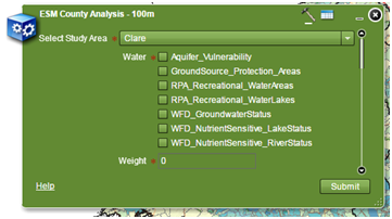
<param type="multivalue:string" name="Water" required="true" visible="true" label="Water">
<choicelist>
<choice value="Aquifer_Vulnerability" />
<choice value="GroundSource_Protection_Areas"/>
<choice value="RPA_Recreational_WaterAreas"/>
<choice value="RPA_Recreational_WaterLakes"/>
<choice value="WFD_GroundwaterStatus"/>
<choice value="WFD_NutrientSensitive_LakeStatus"/>
<choice value="WFD_NutrientSensitive_RiverStatus"/>
</choicelist>
</param>
Any suggestions or comments welcome
Thanks
Justin