- Home
- :
- All Communities
- :
- Learning
- :
- ArcGIS Tutorials
- :
- ArcGIS Tutorials Questions
- :
- Re: Extract roof form tool from lidar data errors
- Subscribe to RSS Feed
- Mark Topic as New
- Mark Topic as Read
- Float this Topic for Current User
- Bookmark
- Subscribe
- Mute
- Printer Friendly Page
Extract roof form tool from lidar data errors
- Mark as New
- Bookmark
- Subscribe
- Mute
- Subscribe to RSS Feed
- Permalink
Hello,
I want to extract the roof forms of buildings using Lidar data and buildings of Amsterdam.
I followed all the steps of the Esri tutorial for extracting rooftops from Lidar data.
I created a all the elevations layers (DSM, DTM, and nDSM) following all the steps of the tasks.
After running the extract roof form I get an error
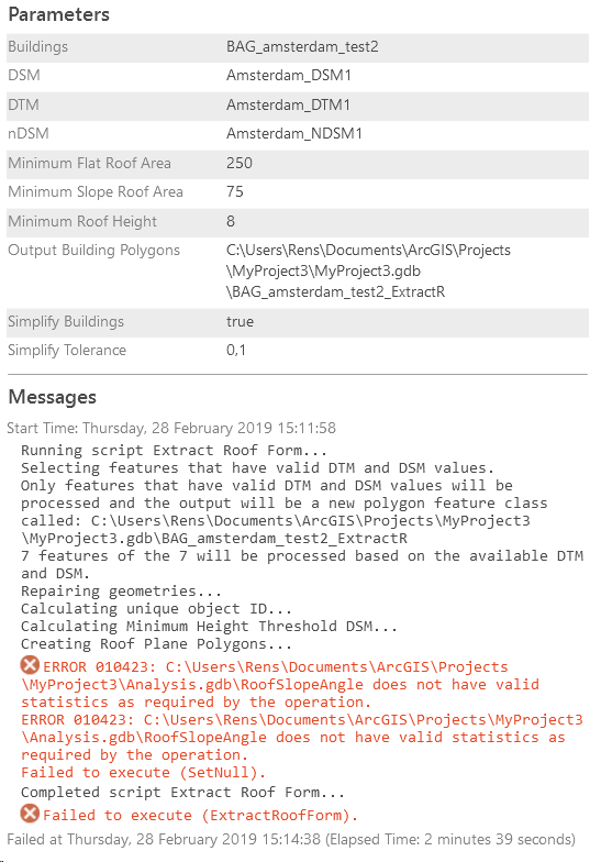
The parameters are as following:
- minimum flat roof area: 250
- minimum slope roof area: 75
- minimum roof height: 8
First, after running I got the error 000735 that said that the parameters are invalid.
After playing with the parameters and using other building data I got the error 010423.
Who can help me out?

Greetings,
Rens
Solved! Go to Solution.
- Mark as New
- Bookmark
- Subscribe
- Mute
- Subscribe to RSS Feed
- Permalink
Honestly, the only thing I can tell you is keep trying. My experience is that I get the tools to work sometimes, but not every time. I just kept running through it, and eventually it works. I'm fairly certain that I don't change the parameters I'm using, so I don't know why it only works sometimes. Half the time my data is floating hundreds of feet in the air and nothing I do can get it to sit on the ground. There is not nearly enough information in the Local Government 3D Basemaps solution both online and in the individual task steps to explain to me what's happening and why.
Essentially, my tip for you is that I hit "Run" and hope for the best.
- Mark as New
- Bookmark
- Subscribe
- Mute
- Subscribe to RSS Feed
- Permalink
Hi Jen,
We just (2 days ago) fixed a number of bugs including the SetNull (Andrew) and Invalid field type bugs in our latest release. Could you try and see if you still have issues with your data using this release:
http://solutions.arcgis.com/local-government/help/local-government-scenes/get-started/
If issues continue, can you please share some of data so we can get to the bottom of this. To speed up your testing, just select a couple of buildings and run.
Thanks Gert
- Mark as New
- Bookmark
- Subscribe
- Mute
- Subscribe to RSS Feed
- Permalink
I have two issues now with it. Extracting an elevation surface used to take at most an hour, but I have tried to do this multiple times and has taken 8+ hours each time, one of them taking 63 hours to run. I'm currently in the middle of trying to extract elevation surfaces and it has thus far taken 4 hours. It has also generated a DSM/DTM/nDSM that sits about 800 ft in the air, which is why I'm running it again, with different parameters and environments this time.
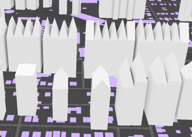
My other issue is with editing the 3D buildings once they are generated. For the buildings that I have generated, both with this version and the last version, I want to make them more realistic. My borough has many twin and row homes, and the roof forms generated often end up looking like this (in addition to no matter what I do, they will not sit on the ground):

The Roof Form Extraction Process page from the Local Government 3D Basemaps solution page describes editing the Roof Form attributes, but then doesn't explain how to turn the newly updated polygon attribute information into the multipatch feature class I'm looking for. I made changes to hundreds of buildings in the RoofForm polygon layer generated in the building creation process, but these changes don't modify the multipatch 3D buildings. The editing that can be done to a multipatch feature class is proving to be very difficult, and much more time consuming than editing the polygon attributes. This issue may be more user error than the program itself, but I am not finding any resources that describe how to make changes to, and then update the multipatch feature class that isn't manually moving vertices.
Please let me know if there's something I'm missing, but currently, though the process may generate less non-specific error messages, it's just as frustrating.
- Mark as New
- Bookmark
- Subscribe
- Mute
- Subscribe to RSS Feed
- Permalink
Hi Jen,
Extracting elevation all depends on extent of the lidar and the resolution of the rasters. So what size area are you trying to process and at what resolution? We have done county wide lidar sets at 0.5m resolution and that took around 12h.
If your DEM etc are too high / low, there might be an issue with your units so potentially issues with the projection of the las files. Check you are using the correct projected coordinate system and that the las Z values are the same as the XY units.
If you want to manually edit multipatches, you need to convert the polygons with rules. This can be done through the Fuse Roof Form Segments task in the solution template or alternatively use Layer 3D to Feature Class to create multipatches from a 3D polygon layer.
Regards gert
- Mark as New
- Bookmark
- Subscribe
- Mute
- Subscribe to RSS Feed
- Permalink
Gert,
The borough I work for is less than 3 square miles, with the LAS dataset being just about the same area at a resolution of 1.5 feet. I did not have this problem of taking 8+ hours before the update. I was trying to run it again with a different projected coordinate system but after it ran for 6 hours, I had to stop the process, so I will be trying again soon.
I will look into the Fuse Roof Form Segments task and the Layer 3D to Feature Class tool for my other issue. Thank you!
- Mark as New
- Bookmark
- Subscribe
- Mute
- Subscribe to RSS Feed
- Permalink
I was finally able to create acceptable multipatch buildings, but I'm running into an issue with trying to create schematic trees.
ERROR 010423: C:\Users\james\Documents\ArcGIS\Packages\LocalGovernment3Dbasemaps_B9FE7822-0621-4271-8E3D-FA3C4CA7C26B\p20\Intermediate.gdb\VegSinkRaster does not have valid statistics as required by the operation.
ERROR 010423: C:\Users\james\Documents\ArcGIS\Packages\LocalGovernment3Dbasemaps_B9FE7822-0621-4271-8E3D-FA3C4CA7C26B\p20\Intermediate.gdb\VegSinkRaster does not have valid statistics as required by the operation.
Failed to execute (SetNull).
I tried to run the Calculate Statistics tool on VegSinkRaster, but I'm still receiving this message. Is there something else I can do to get this task to work?
Thank you!
- Mark as New
- Bookmark
- Subscribe
- Mute
- Subscribe to RSS Feed
- Permalink
Hi Jen, can you share the parameters that you used? I may need to see a sample of your data to reproduce if you are able to provide it.
Thanks,
Dan
- Mark as New
- Bookmark
- Subscribe
- Mute
- Subscribe to RSS Feed
- Permalink
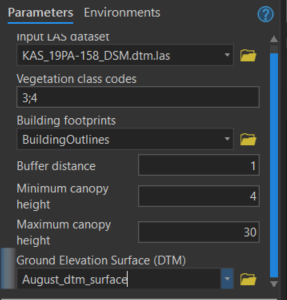
Here are my parameters. For buffer distance, and canopy heights, I just accepted the values it auto-populated.

Let me know if you want me to email you a copy of my data.
- Mark as New
- Bookmark
- Subscribe
- Mute
- Subscribe to RSS Feed
- Permalink
Thank you Jen. It looks like you are using a straight LAS file as an input. Can you try adding that to a LAS Dataset and try again? If that still doesn't work, please send a sample of your data over, dhedges at esri dot com.
- Mark as New
- Bookmark
- Subscribe
- Mute
- Subscribe to RSS Feed
- Permalink
Hi all,
I apologize that this lesson is causing you some problems. We are currently working on updating the workflow, and will post to this thread once it is released. In the meantime, you should refer to this workflow instead: Local Government 3D Basemaps. You can navigate through the lesson using the tabs on the left (Install add-in, etc.)