- Home
- :
- All Communities
- :
- Products
- :
- ArcGIS Survey123
- :
- ArcGIS Survey123 Questions
- :
- Survey123 sometimes mis-placing points on map
- Subscribe to RSS Feed
- Mark Topic as New
- Mark Topic as Read
- Float this Topic for Current User
- Bookmark
- Subscribe
- Mute
- Printer Friendly Page
- Mark as New
- Bookmark
- Subscribe
- Mute
- Subscribe to RSS Feed
- Permalink
It seems that Survey123 is putting two points in the wrong location. Perhaps the most interesting piece of this puzzle is that of the 8 surveys assigned to this point, 6 are in the correct location and two are not. Also interesting is that the two mis-placed sites are not exactly on top of each other; they are placed about 53 feet apart.
Our survey does not have a visible map where a user can place a point for the survey. Instead, a user is required to select a ‘Site Name’. Once the site name is selected, we use the pulldata() function to pull the lat/lon of the selected site from a csv file (IPM_Sites.csv). Once that info is available, the point for the survey is calculated based on the lat/lon pulled.

This works as expected except for one site two times - River Island. For some reason, the map point is placed about 40 miles southwest of the actual location (see screen cap below). I am unable to figure out why that is happening.

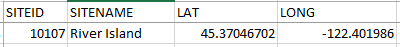
The screen cap below is from the Choices worksheet. You can see that when ‘River Island’ is selected, the site id value is 10107. I have verified that within the ipmSiteList that there is only one record with a label of River Island and only one instance of the name/siteid 10107

The next screen cap is from the csv file that the pulldata() function hits. Siteid 10107 should return the correct/expected lat/lon. I have verified that in the csv file there is only one record with a siteid 10107
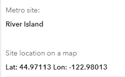
Instead of putting the point at the River Island lat/lon, Survey123 is putting it at 44.97, -122.98 (screen cap below is from the ‘individual response report’ on the data tab of survey123 web site).
Any thoughts about what’s going on with those two surveys?
Solved! Go to Solution.
Accepted Solutions
- Mark as New
- Bookmark
- Subscribe
- Mute
- Subscribe to RSS Feed
- Permalink
I worked with Tom offline on this. There was an issue with the geopoint questions being non relevant and receiving a calculation- given the change to make non-relevant questions not calculate in 2.7, the calculation was no longer working.
- Mark as New
- Bookmark
- Subscribe
- Mute
- Subscribe to RSS Feed
- Permalink
Hi Tom,
Can you provide the XLS file of the survey? When you say that there is no map, does that mean there is no geopoint question? If so, how does the location get calculated?
- Mark as New
- Bookmark
- Subscribe
- Mute
- Subscribe to RSS Feed
- Permalink
Hi James. I have previously shared the survey with you. If you'd like, i can send you another copy.
There is a geopoint question which is a calculation (see first screen cap in the original post). The result of the 'pulldata()' operation is the calculated value that is assigned to the geopoint question.
I appreciate how quickly you responded to my question. thanks.
- Mark as New
- Bookmark
- Subscribe
- Mute
- Subscribe to RSS Feed
- Permalink
I worked with Tom offline on this. There was an issue with the geopoint questions being non relevant and receiving a calculation- given the change to make non-relevant questions not calculate in 2.7, the calculation was no longer working.