- Home
- :
- All Communities
- :
- Products
- :
- ArcGIS Survey123
- :
- ArcGIS Survey123 Questions
- :
- Re: Survey123 Pulldata zoom to location
- Subscribe to RSS Feed
- Mark Topic as New
- Mark Topic as Read
- Float this Topic for Current User
- Bookmark
- Subscribe
- Mute
- Printer Friendly Page
Survey123 Pulldata zoom to location
- Mark as New
- Bookmark
- Subscribe
- Mute
- Subscribe to RSS Feed
- Permalink
Is there a way to use PULLDATA to zoom to the location for a record in pulldata? I want to read a barcode for an existing feature (sign) that has attributes in the media\*.CSV. I then want to geocode an XY location that is stored in the CSV file and then show it on the map in Survey123. A new survey record will be created at the new location. Can this be done?
- Mark as New
- Bookmark
- Subscribe
- Mute
- Subscribe to RSS Feed
- Permalink
Hi Jonathan,
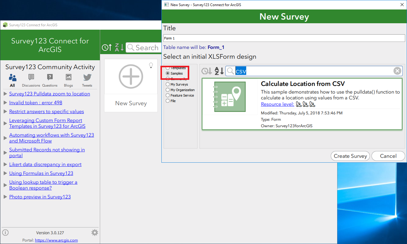
If I'm not mistaken, the exact functionality you describe is covered in the 'Calculate Location from CSV' sample provided in Survey123 Connect.
- Mark as New
- Bookmark
- Subscribe
- Mute
- Subscribe to RSS Feed
- Permalink
Thanks Claire, can you point me to exactly where I can find this sample? Where do I click to see it?
- Mark as New
- Bookmark
- Subscribe
- Mute
- Subscribe to RSS Feed
- Permalink
OK, I found it online but there is no option to download it. Can you enable download or attach the file so I can see how this was done? Thanks!
http://survey123.maps.arcgis.com/home/item.html?id=8767424aa9b745d98af62eab34808780
- Mark as New
- Bookmark
- Subscribe
- Mute
- Subscribe to RSS Feed
- Permalink
Hi Jonathan,
You can access the Samples via Survey123 Connect as below:

Mikie
- Mark as New
- Bookmark
- Subscribe
- Mute
- Subscribe to RSS Feed
- Permalink
Excellent, thanks Michael! I was searching to enhance an existing survey, would have never thought about creating a new one to find these samples.