- Home
- :
- All Communities
- :
- Products
- :
- ArcGIS Survey123
- :
- ArcGIS Survey123 Questions
- :
- Re: Reverse Geocoding in Survey123 Webform not wor...
- Subscribe to RSS Feed
- Mark Topic as New
- Mark Topic as Read
- Float this Topic for Current User
- Bookmark
- Subscribe
- Mute
- Printer Friendly Page
Reverse Geocoding in Survey123 Webform not working
- Mark as New
- Bookmark
- Subscribe
- Mute
- Subscribe to RSS Feed
- Permalink
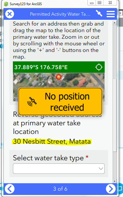
I was wondering if reverse geocoding using the pull down function published out of Survey123 Connects works in the the Survey123 web form. I have tested this in the Survey123 field app for desktop and it works but it does not seem to be pulling the location info from our geocoding service through the webform.
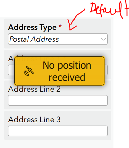
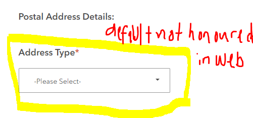
Another issue is the default value for a select_one type question is not working in the webform either when it is working fine in the Survey123 field app for desktop.
Any ideas? Let me know if I need to provide additional information.
Survey is public and can be accessed here: https://arcg.is/0LDLSe but the geocoder used is not accessible if not signed into our organisation but it is a public geocoder so should still populate the address in the database even if you are not able to select it in the map address search.
Thank you,
Simon
- Mark as New
- Bookmark
- Subscribe
- Mute
- Subscribe to RSS Feed
- Permalink
Hi Simon,
I can see an issue in the reverse geocode request - it is sending a token, causing a security error.
Could I also ask that you confirm the reverse geocoding task works with a lat,long coordinate? When trying to work with the geocode (for example, Reverse Geocode: (LINZ_Street_Address_Locator_Test) ), I'm not getting a result.
- Mark as New
- Bookmark
- Subscribe
- Mute
- Subscribe to RSS Feed
- Permalink
Hi James,
Thank you for your reply. I can’t seem to get the correct syntax for populating the geocoded address from a lat long coordinate using the rest end geocoding service that we’ve created from LINZ data https://gistest.boprc.govt.nz/server/rest/services/LINZ_Street_Address_Locator_Test/GeocodeServer/reverseGeocode
Here is the feature service (public) that is used to store the records from the survey. https://services1.arcgis.com/TWsoAGve3wb3oFHK/arcgis/rest/services/service_6d293b9993ab4a708a05940c8f52c079/FeatureServer
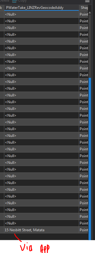
I have repeated the same test using the same address. 6 Mair Street, Matatā. See Object ID 51 and 52. I have entered similar data both in the webapp and in the desktop field app of survey123 and the results are different.
The X and Y lat long fields are populated everytime in both apps using the esri geocoder with simply the pulldata function but the reversegeocode.location and reversegeocode.adress.Match_addy only seem to be working when being run out of the desktop app (tested using both ESRI and our test LINZ geocoder).
Is it possible that this could be a bug?
hidden
PWaterTake_LINZRevGeocodeAddy
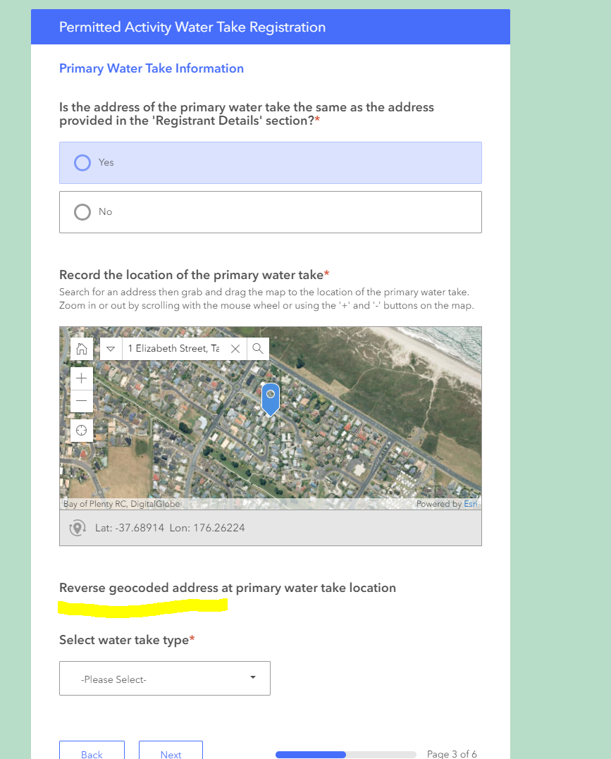
Reverse geocoded address at primary water take location
pulldata("@geopoint",$,"reversegeocode.address.Match_addr", "https://gistest.boprc.govt.nz/server/rest/services/LINZ_Street_Address_Locator_Test/GeocodeServer") hidden PWaterTake_LINZRevGeocodeX Reverse geocoded location at LINZ address point X Coordinate pulldata("@geopoint",$, "reversegeocode.location.x", "https://gistest.boprc.govt.nz/server/rest/services/LINZ_Street_Address_Locator_Test/GeocodeServer")
hidden
PWaterTake_LINZRevGeocodeY
Reverse geocoded location at LINZ address point Y Coordinate
pulldata("@geopoint",$, "reversegeocode.location.y", "https://gistest.boprc.govt.nz/server/rest/services/LINZ_Street_Address_Locator_Test/GeocodeServer") hidden ESRIGeocodedAddressPrimaryTake ESRIGeocodedAddressPrimaryTake pulldata("@geopoint",$,"reversegeocode.address.Match_addr")
hidden
LatitudePrimaryTake
Latitude
pulldata("@geopoint", $,"y") hidden LongitudePrimaryTake Longitude pulldata("@geopoint", $,"x")
Cheers,
Simon Allard
GIS Analyst
Bay of Plenty Regional Council Toi Moana
- Mark as New
- Bookmark
- Subscribe
- Mute
- Subscribe to RSS Feed
- Permalink
Hi Simon,
The issue with regard to the token is a bug and we will look to fix it.
- Mark as New
- Bookmark
- Subscribe
- Mute
- Subscribe to RSS Feed
- Permalink
Do we have a BUG number logged for this?
- Mark as New
- Bookmark
- Subscribe
- Mute
- Subscribe to RSS Feed
- Permalink
Hi Éric,
There is not an Esri Support BUG-# number associated with this issue. If you want to work with Support to have one filed, please let me know.
- Mark as New
- Bookmark
- Subscribe
- Mute
- Subscribe to RSS Feed
- Permalink
Has this been fixed yet?