- Home
- :
- All Communities
- :
- Products
- :
- ArcGIS Survey123
- :
- ArcGIS Survey123 Questions
- :
- pulldata() to geopoint the facility being surveyed...
- Subscribe to RSS Feed
- Mark Topic as New
- Mark Topic as Read
- Float this Topic for Current User
- Bookmark
- Subscribe
- Mute
- Printer Friendly Page
pulldata() to geopoint the facility being surveyed, not location of submitter
- Mark as New
- Bookmark
- Subscribe
- Mute
- Subscribe to RSS Feed
- Permalink
I'm trying to do a pulldata() function to do the following: I have a list of facilities to choose from, and want the survey location to be recorded as the address of the specific facility that is chosen from the dropdown menu. The reason I need to do this is so that I can attach the survey to the facility when used as a service layer in AGOL. Does that make sense? I don't want the survey to be geocoded to where the person is when the complete and submit the survey.
I've been working on it the entire day and for some reason, it keeps returning the wrong X,Y coordinates for some and is returning nothing for others. Here is what I have:
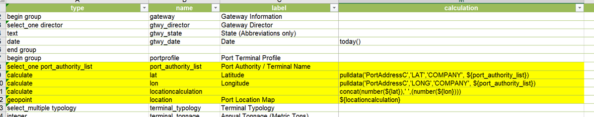
NOTE: PortAddressC is the csv file
COMPANY is the list of facilities that match up to the port_authority_list
PLEASE HELP ME! I'm losing my mind.
- Mark as New
- Bookmark
- Subscribe
- Mute
- Subscribe to RSS Feed
- Permalink
Hi Branden
At first glance your XLSForm looks okay (besides a superfluous closing parenthesis on the location calculation). Could you please provide your XLSForm and CSV so I can take a closer look? You can attach files to a GeoNet post using the 'advanced editor'.
Best,
Jim
- Mark as New
- Bookmark
- Subscribe
- Mute
- Subscribe to RSS Feed
- Permalink
hi
i have a similar problem and this is what i do to fix:
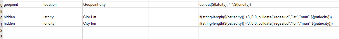
in this case ${patietcity} is porth_authority_list.
i need to check if my city is not selected and put a defautl lat lon of 0 0.
also check in the csv the values for port_authority_list is exact as in the the xlsx.
- Mark as New
- Bookmark
- Subscribe
- Mute
- Subscribe to RSS Feed
- Permalink
Hi Jose,
your latcity and loncity should both only have '0' - combined, the caclulation in location would create '0 0'.