- Home
- :
- All Communities
- :
- Products
- :
- ArcGIS Survey123
- :
- ArcGIS Survey123 Questions
- :
- Hiding a geopoint populated via pulldata
- Subscribe to RSS Feed
- Mark Topic as New
- Mark Topic as Read
- Float this Topic for Current User
- Bookmark
- Subscribe
- Mute
- Printer Friendly Page
- Mark as New
- Bookmark
- Subscribe
- Mute
- Subscribe to RSS Feed
- Permalink
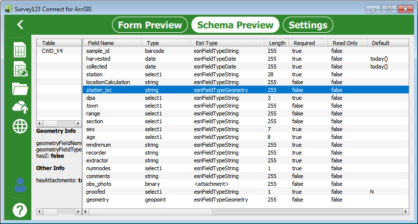
I have series of deer check stations where the station's location does not need to be collected by the user, but is needed for later data displays. I've employed the pulldata function to populate the field, but would like to hide it from users, especially because many of the stations will not have connectivity anyway. I tried using type "hidden" and defining the field as esriFieldTypeGeometry, but when I try to publish the form I get an error message that it has 2 geopoints and only one is allowed. In the screen shot below the field of interest (station_loc) is listed as Type string though the ESRI Type is Geometry. The second geopoint does not show up in the spreadsheet, but does in the schema (last row). Is there a workaround? Thanks.
Solved! Go to Solution.
Accepted Solutions
- Mark as New
- Bookmark
- Subscribe
- Mute
- Subscribe to RSS Feed
- Permalink
Hi Bob. This is an interesting use case. We had not run into this one before. The reason why you are getting the error is that Connect is trying to add to geometry fields into the feature layer and this is not supported in the ArcGIS data model. Once you add a geopoint question, you can't add any more geometry fields within that layer.
I guess it would be handy in this case to have an appearance that would allow you hide the geopoint question, but at this point we do not have it. I would suggest that you for now put the geopoint at the end and you calculate the location as you are currently doing. Try making the geopoint question read-only so the user cannot overwrite the location you assign.
As for the hidden question, you can either remove it, or if you prefer you can add two hidden questions where you can store the X and Y coordinates separately (as the result of your calculation).
- Mark as New
- Bookmark
- Subscribe
- Mute
- Subscribe to RSS Feed
- Permalink
How about a "hidden_geopoint" question?
What matters in this survey is the analyze tool of the web map version, providing data grouped by a question in the survey called division.
In my case, the user do not need to enter lat long as they are being pulled from the external file using a fixed location of each division. Since a geopoint is a required value of every survey - whether I use it or not, I might as well add lat long since they look better on the web map by Division than having an arbitrary 0,0 location.
- Mark as New
- Bookmark
- Subscribe
- Mute
- Subscribe to RSS Feed
- Permalink
+1 to the idea of a hidden geopoint (if it is still being considered), as it would be rather helpful to us in a workflow very similar to what the original poster described.