- Home
- :
- All Communities
- :
- Products
- :
- ArcGIS Spatial Analyst
- :
- ArcGIS Spatial Analyst Questions
- :
- Re: Topographic profiles with the highest slope
- Subscribe to RSS Feed
- Mark Topic as New
- Mark Topic as Read
- Float this Topic for Current User
- Bookmark
- Subscribe
- Mute
- Printer Friendly Page
Topographic profiles with the highest slope
- Mark as New
- Bookmark
- Subscribe
- Mute
- Subscribe to RSS Feed
- Permalink
- Report Inappropriate Content
Hi everybody,
First, sorry for my english, it's not perfect and i'll try to do my best here
I'm actually working on a project in Madagascar and i have a lot of work do to with rockslide. Some place might be concern by this phenom and i'd like to work on Arcgis to calculate the propagation of blocks from a cliff in my area.
The idea is "simple" and i've done it (in the past) on Mapinfo using topographic profile (with a raster) and then priting the profile and working on it. I'd like to do this on Arcgis with the software if it's possible.
I have a DTM and a raster with the slopes of my area. I have some cliffs (materialized by a polylign for example) and i'll like to draw a topographic profile in the highest slope. This is relatively easy i think as there is a tool in arcmap to draw this directly.
BUT, i'd like to draw a profile who start from the cliff, and with a certain angle (°). The angle is from an imaginary horizontal line at the top of the cliff. I would like to know where the line (from the top of the cliff) intersect the ground.
An image is better to illustrate (see bellow).

Drawing the topographic profile with the highest slope is possible for sure (even if i'm not sure how arcgis draw this profil)...
This procedure is doable is Arcscène (in 3D) also and it might help me to work with that.
Maybe it's possible. If someone have any leeds, clues, that'd be great
I would really much appreciate some help here
Have a nice evening
Sylvain
- Mark as New
- Bookmark
- Subscribe
- Mute
- Subscribe to RSS Feed
- Permalink
- Report Inappropriate Content
Nobody has any idea where to start, or if it's even possible?
I have check and i know drawing with a certain angle from a point is possible in Covadis (on a profile). Maybe there is a way to do on Arcgis?
If not, maybe can i draw all my profile in Arcgis, and work then in Covadi.
Any help would be much appareciated
Thanks
Sylvain
- Mark as New
- Bookmark
- Subscribe
- Mute
- Subscribe to RSS Feed
- Permalink
- Report Inappropriate Content
I've done something similar for showing where railroad tracks at different percent grades would need to go into tunnel. You'll want to create a contour line along your cliff edge and assign it the actual ground elevation in an elevation field. Then draw another line well past where you would expect the slope to intersect the ground (make it a nice round horizontal distance like 1000 feet). Then calculate what the elevation would be for a 32 degree slope at 1000 feet out based on your initial elevation and add that elevation to your elevation field. Copy your 2 lines into 2 new feature classes and adjust the elevation based on your other slopes of interest. Then convert your contour lines to a surface (1 surface for each slope) and add to your profile graph along with the real ground elevation surface. You can also use raster calculator to create a surface that shows where the slope is below ground versus above ground.
- Mark as New
- Bookmark
- Subscribe
- Mute
- Subscribe to RSS Feed
- Permalink
- Report Inappropriate Content
HI Bond,
Thanks a lot for your answer. That's seems a lot more difficult than i thought!
There is a lot of things to do, even if it's seems that you understand very well my problem.
Can you take some times to explain step by step how can i do.
1) Draw a contour line along my cliff edge and assign the actual elevation (in a field)-> OK, understood
2) I don't understand why i need to draw approximatively an other line where i expect the slope intersect the ground?
3) Then i'm lost!
Do you think it will be easier with the rastr calculator to do this problem?
At the end, i'd need a polygone from the edge of my cliff for my first slope 32° and 2 othes ones for the 2 others slope
Thanks a lot for your help!
- Mark as New
- Bookmark
- Subscribe
- Mute
- Subscribe to RSS Feed
- Permalink
- Report Inappropriate Content
The second line just needs to be a fixed horizontal distance from your cliff so you can determine the elevation based on the angle (see image - I hope that helps a little and I haven't made any math mistakes). Then after you have your two surfaces (ground surface and slope surface) you can show both on a profile graph or use raster calculator to compare the ground surface to the slope surface to get the line of intersection.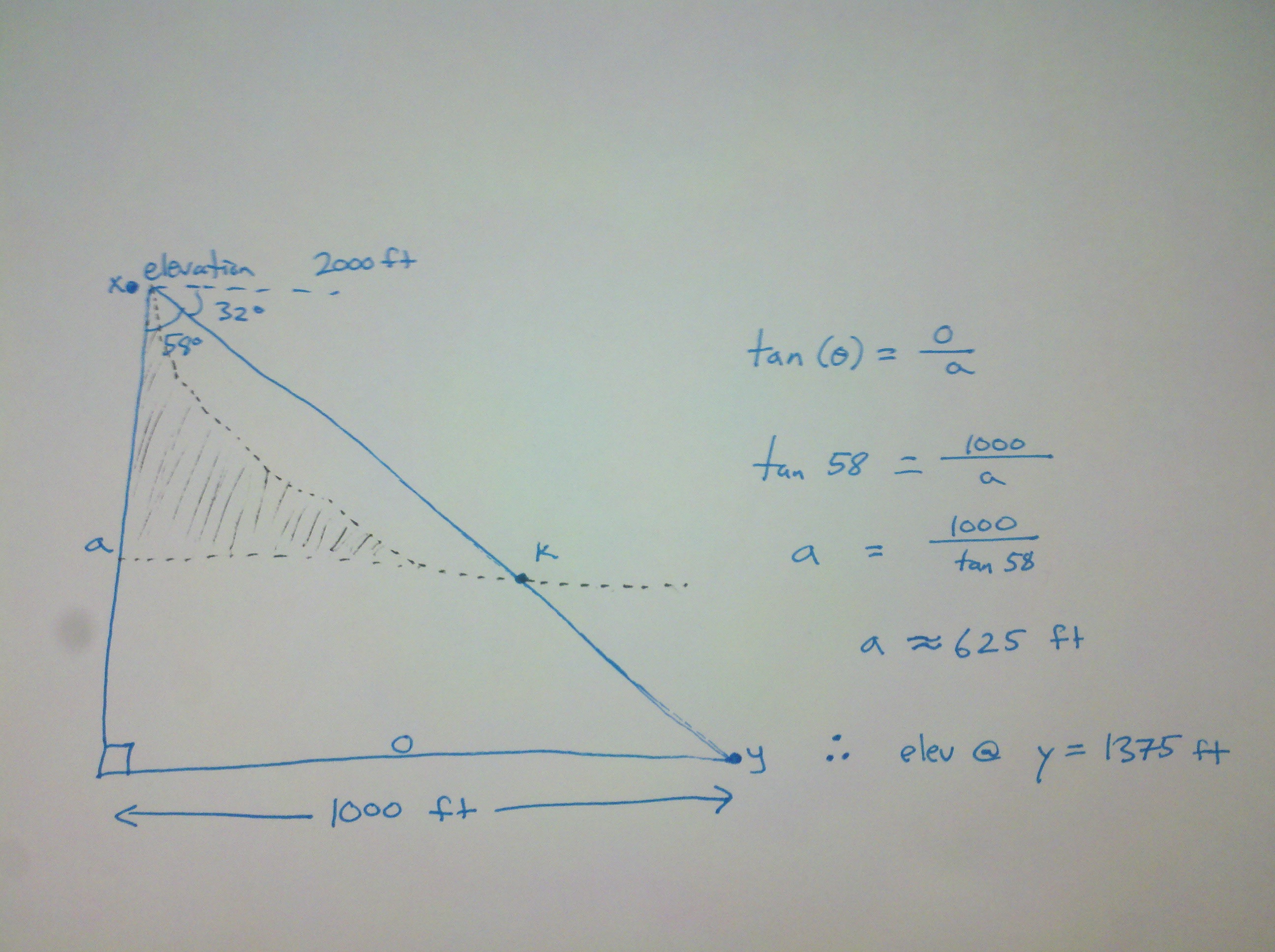
There is likely an easier way, but this method worked for me.
- Mark as New
- Bookmark
- Subscribe
- Mute
- Subscribe to RSS Feed
- Permalink
- Report Inappropriate Content
HI Bond,
Thanks for the explanation about my problem. The real problem here is that
my first line has not only one ground elevation. The height of the line is
different of course, depend where you are. So i'm not sure this system will
work?
But i understand the idea, thanks to your image.
Also, the problem is that i have to do a lot of profile (hundred, maybe
more). I could maybe cut my polylign into small polylign (same height).
2014-12-08 23:22 GMT+03:00 Bond Harper <geonet@esri.com>:
Topographic profiles with the highest slope
reply from Bond Harper
<http://jiveon.jivesoftware.com/wf/click?upn=Dg1s4x8le7Lmxv8KWGaqo7A4BXwO9PY1WvQ5cXCtK4-2FSrrmH2XhO94E70TEoPWcSsvlBNEYiyITFkGY670Tsj-2BEary0mv1TncXIQ8wZ6vs8-3D_SR9W2VKDgu2LLmpLZHslzXRkGhkz6BZH-2F0HfqCVFo3sobsKDgsW1OYnVfLhvDxwJAoetRCHoL5oSClGFsAHN3rcoVGPdIbsDpU9KYc9rJ2y4G-2F-2BxMAB98e-2FendKS00GJ-2Blf5oJQRXjMQei5Yk8gW-2ByWiu6hbCfB5ooV8b8uKyccfuvVzSttIKkvrVRPgl7ppUKMaT2ZYWdVlPpifBBnbj6pYHPVtR6aY-2FT-2F71BZzeE6J1W4BYXkF3TffX7h36namM66ToH4pzy5WT-2FpOBYKyugVswDEkwimvjaEHAdSuxFMUZv7yCxfDQoaC2d-2BJ2y5E>
in PONS Sylvain - View the full discussion
<http://jiveon.jivesoftware.com/wf/click?upn=Dg1s4x8le7Lmxv8KWGaqo0VQjeJBYpG9HGC8QZBT-2FEyBD042-2B6joj7mkOCOX5beoFnc6aZOAe4H70-2BxAfXbjEGgckRQ9vhmjslIgJHZxPTs-3D_SR9W2VKDgu2LLmpLZHslzXRkGhkz6BZH-2F0HfqCVFo3sobsKDgsW1OYnVfLhvDxwJAoetRCHoL5oSClGFsAHN3rcoVGPdIbsDpU9KYc9rJ2y4G-2F-2BxMAB98e-2FendKS00GJ-2Blf5oJQRXjMQei5Yk8gW-2B53cHpc3o18hUuDrS-2FJYqi5vp6HuSIjRbhhIOMhKQgcIhMqsszCN1JynBG7uP8QfGnzg8vgMBh-2BGj3pF6qoYOiZiNTRG0IKqBowWG2iyz4bkU47BBEbBgawlvU2ygYj-2FOiKdmLrxoxU1k4V9RXlQJXVdRgw9D6hfg3oqJQcSSxZt>
- Mark as New
- Bookmark
- Subscribe
- Mute
- Subscribe to RSS Feed
- Permalink
- Report Inappropriate Content
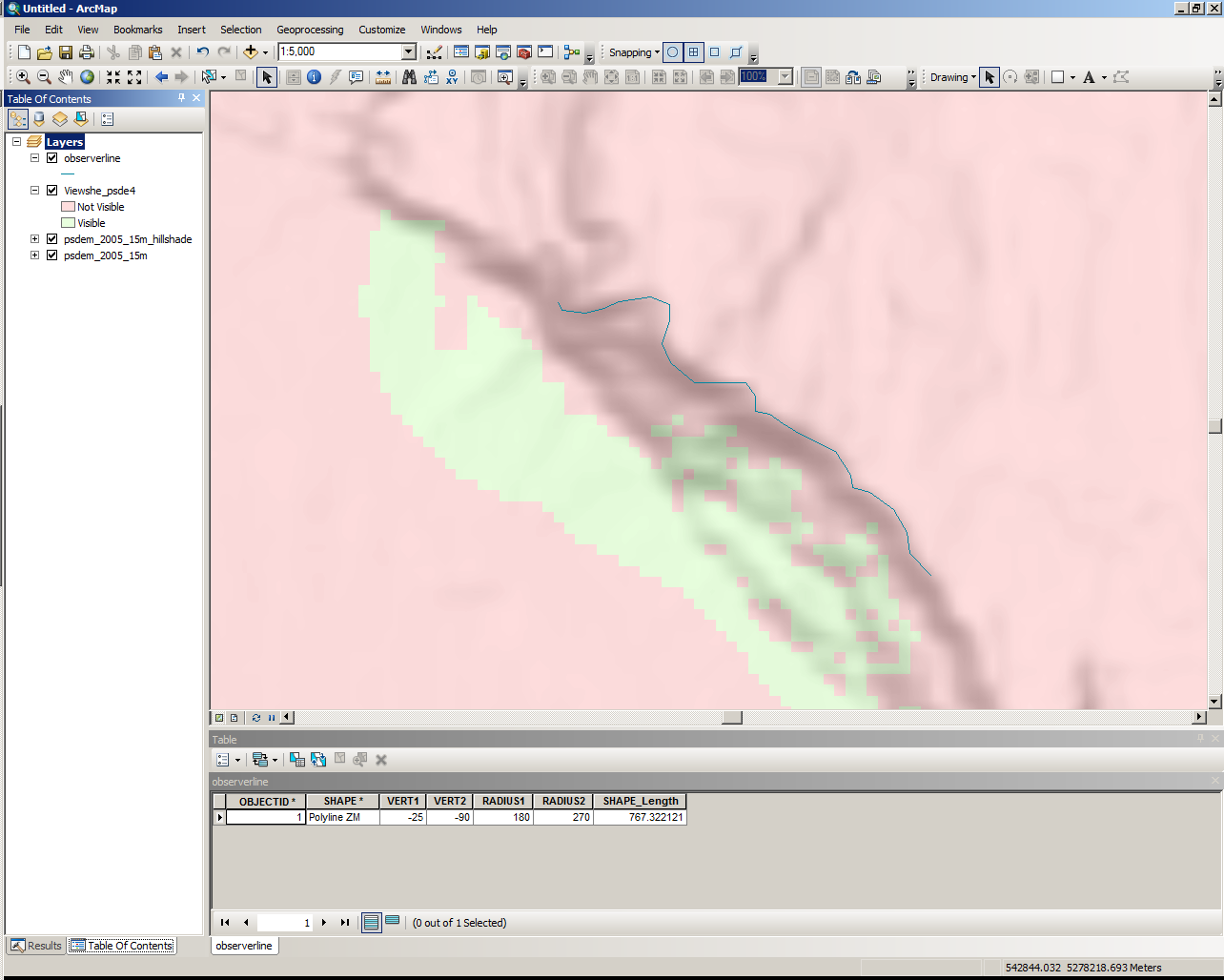
I might not be understanding the problem completely here, but it occurs to me that another approach you might take is to use Viewshed in map view. You could create a line along the top of your landslide scarp and then define angles to bracket the search area on the raster below, as if you were standing on the bluff and using an inclinometer. See the attached image. The power of this method is that you could do zonal statistics on an intersection of the visible areas with your slope map. You could also vectorize this raster and convert it to cross section features. That should give the same result as starting with a surface profile in cross section view and then drawing a line with your angle of declination to find the intersection on the surface below the bluff.
- Mark as New
- Bookmark
- Subscribe
- Mute
- Subscribe to RSS Feed
- Permalink
- Report Inappropriate Content
Hi Evan,
Also, thanks a lot for taking the time to answer me about this.
I understand perfectly the idea with the Viewshed in Mapview, even if i'm
not aware how to do this on Arcmap.
Actually, i have not drawn the actual line (on the top of my cliffs), but
it will be easy. The idea of an inclinometer is actually pretty good i
think, if i can choose the angles to bracket the search area.
But obviously for me, it's seems pretty difficult to realized this
operation on Arcgis. I have no idea where to start, sadly.
2014-12-09 0:11 GMT+03:00 Evan Thoms <geonet@esri.com>:
Topographic profiles with the highest slope
reply from Evan Thoms
<http://jiveon.jivesoftware.com/wf/click?upn=Dg1s4x8le7Lmxv8KWGaqo7A4BXwO9PY1WvQ5cXCtK4-2Bh-2B-2FpGP4gx082DJOp-2Bz6mhojPMCSBw07RwL42-2B1XBFppS3XV-2Fd0hu-2BpZIrtnh-2FmeE-3D_SR9W2VKDgu2LLmpLZHslzXRkGhkz6BZH-2F0HfqCVFo3sobsKDgsW1OYnVfLhvDxwJAoetRCHoL5oSClGFsAHN3rcoVGPdIbsDpU9KYc9rJ2yu8aXkHb9tRLgeXoSddLDc7IeNGUY3xJlY6Yn3kZVbtXLvvB-2FAUtDsD8Wm9JvSjZysAUwUVkkuqWEReBKypWjNKhB0v5gBf-2BmVHC85lP02i-2F8qYlydwoMheCRa-2FlA7HcT8r8ZR-2FzpaBb8pJgW-2B7DX4B9ZwtVNvquhTVCYLTlsyvgFLJ1KOrcGYYaABEcq4PsTMYRftaUJggNa61cZI-2F-2FcO>
in PONS Sylvain - View the full discussion
<http://jiveon.jivesoftware.com/wf/click?upn=Dg1s4x8le7Lmxv8KWGaqo0VQjeJBYpG9HGC8QZBT-2FExyn-2Bw7viFnKzL0MXnEu8GqUKAm3oOuHuEXJk1z75hxO0oibTk-2BrEKftdcI6tvOCJM-3D_SR9W2VKDgu2LLmpLZHslzXRkGhkz6BZH-2F0HfqCVFo3sobsKDgsW1OYnVfLhvDxwJAoetRCHoL5oSClGFsAHN3rcoVGPdIbsDpU9KYc9rJ2yu8aXkHb9tRLgeXoSddLDc7IeNGUY3xJlY6Yn3kZVbtd5Onh0MnOp1bOJgAJ14dvFVEd8tHuBDHqRKIwWwblB56AWNjw0a5b0EDnmi2epoGyX-2BNCdL25JlSCUpEdP2y-2BnI1dKsWAAhetfBjiDohXaD9PR0IQAbFCe4uQaTKV2MrQSCob8KJUMREMm8kU9KQnioz-2F-2FZqJhuGWpxHUoGuB4w>