- Home
- :
- All Communities
- :
- Products
- :
- ArcGIS Spatial Analyst
- :
- ArcGIS Spatial Analyst Questions
- :
- Reclassify slope (values from 0-10) MCE analysis
- Subscribe to RSS Feed
- Mark Topic as New
- Mark Topic as Read
- Float this Topic for Current User
- Bookmark
- Subscribe
- Mute
- Printer Friendly Page
Reclassify slope (values from 0-10) MCE analysis
- Mark as New
- Bookmark
- Subscribe
- Mute
- Subscribe to RSS Feed
- Permalink
I'm preparing the factors for my Multi Criteria Evaluation Analysis and I need to reclassify my slope with values from 0 - 10
(10 the most ideal aspect , 0 the worst)
(as flatter as better - 10 ....)
I'm not sure how I need to proceed
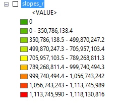
As you can see these are the values of my slope (attached)
Any help is welcome
- Mark as New
- Bookmark
- Subscribe
- Mute
- Subscribe to RSS Feed
- Permalink
If you use the Reclassify tool (Spatial Analyst Toolbox), you can assign an output value to each range of slope value. You can read more about this here: ArcGIS Help (10.2, 10.2.1, and 10.2.2)
Create the 11 classes, reclassify and assign 10 to the flattest area and 0 to highest slope (and 1-9 to the intermediate classes).
- Mark as New
- Bookmark
- Subscribe
- Mute
- Subscribe to RSS Feed
- Permalink
I would also suggest that you use % slope in the initial classification of the slope data PRIOR to going to an ordinal scale, you will notice that your values are a tad ridiculous...this is most probably caused by using meters for your elevation Z and your grid coordinates are in decimal degrees. Project your raster (just don't define it) to a planar coordinate system like UTM etc etc, then calculate you slope as a percentage, examine the histogram, make an informed judgement as to where to place the breaks (ie equal interval, natural breaks, SDev etc etc) then do the reclass. It is so easy to get a nice legend and produce totally useless data.
