- Home
- :
- All Communities
- :
- Products
- :
- ArcGIS Spatial Analyst
- :
- ArcGIS Spatial Analyst Questions
- :
- Point Density Error
- Subscribe to RSS Feed
- Mark Topic as New
- Mark Topic as Read
- Float this Topic for Current User
- Bookmark
- Subscribe
- Mute
- Printer Friendly Page
Point Density Error
- Mark as New
- Bookmark
- Subscribe
- Mute
- Subscribe to RSS Feed
- Permalink
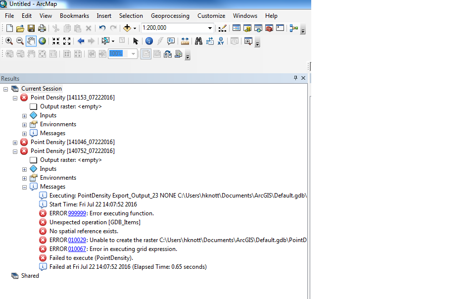
I am working with an excel document of lat/long data and I have displayed the xy data and exported the data and now I am trying to run a point density analysis, however I keep receiving the attached error. I am not sure how to create a spatial reference and I don't remember experiencing this problem in the past while running this tool. I am using coordinate system WGS 1984.
- Mark as New
- Bookmark
- Subscribe
- Mute
- Subscribe to RSS Feed
- Permalink
The layers must have a defined coordinate system, check its properties. If it says undefined, then you need to define it using the Define Projection tool.
In any event, if you are wanting to do density, you should actually project the layer to some projected coordinate system since units/square degree is pretty useless since it is not a consistent measure over the surface of earth.
- Mark as New
- Bookmark
- Subscribe
- Mute
- Subscribe to RSS Feed
- Permalink
It doesn't seem to want to work. Both the project tool and define projection tool ended with error 000289: failed to alter spatial reference.
- Mark as New
- Bookmark
- Subscribe
- Mute
- Subscribe to RSS Feed
- Permalink
You have to give the file the proper spatial reference so that it matches its extent. If the define projection tool doesn't work, then the Project tool will surely fail, since it depends on a properly defined coordinate system.
This error message basically boils down to that, you can examine a recent thread on that error number or view a recent thread where the confusion on what a file is defined as and what someone wants it to be is quite protracted.
Project Raster: Error 000289 Failed to alter spatial reference
try rebooting the computer, moving the file to a new, local drive, examine what the file extent is through its properties and try to get it defined appropriately. Good luck
- Mark as New
- Bookmark
- Subscribe
- Mute
- Subscribe to RSS Feed
- Permalink
so if my data is in decimal degrees what would I want to define as my coordinate system and how would I go about projecting this data
- Mark as New
- Bookmark
- Subscribe
- Mute
- Subscribe to RSS Feed
- Permalink
If your coordinates are in decimal degrees, you would define it as a Geographic Coordinate System with some datum, depending where you got it. Lets say a GCS WGS84
Define Projection—Help | ArcGIS for Desktop
Then you need to pick an appropriate projection for your area... like a UTM, Albers, Lambert (1000s more) or even the web mercator projection (yuck) and project it using the Project tool
for vector Project—Help | ArcGIS for Desktop
for raster Project Raster—Help | ArcGIS for Desktop
Then your quantities/ unit area will have a standard common basis... like units per meter squared, units per kilometer squared or however you want to factor the units/area term. units/square degree is non-sensical since 1 square degree near the north pole is extremely small, compared to the same square degree at the equator,
- Mark as New
- Bookmark
- Subscribe
- Mute
- Subscribe to RSS Feed
- Permalink
Now when trying to project the data to a projected coordinate system I receive an error that says the table was not found. This is just lat long data from an excel file that I added to arcmap, I don't understand what this error entails.
- Mark as New
- Bookmark
- Subscribe
- Mute
- Subscribe to RSS Feed
- Permalink
that table has to be used as an event layer so that it is added to arcmap, then you convert it to a featureclass in a geodatabase and finally you can project it
Adding x,y coordinate data as a layer—Help | ArcGIS for Desktop will get you started
- Mark as New
- Bookmark
- Subscribe
- Mute
- Subscribe to RSS Feed
- Permalink
I still receive the "table not found" error after exporting the data to a feature class.
- Mark as New
- Bookmark
- Subscribe
- Mute
- Subscribe to RSS Feed
- Permalink
zip and post a sample