- Home
- :
- All Communities
- :
- Products
- :
- ArcGIS Spatial Analyst
- :
- ArcGIS Spatial Analyst Questions
- :
- Including rivers into Least Cost Path
- Subscribe to RSS Feed
- Mark Topic as New
- Mark Topic as Read
- Float this Topic for Current User
- Bookmark
- Subscribe
- Mute
- Printer Friendly Page
Including rivers into Least Cost Path
- Mark as New
- Bookmark
- Subscribe
- Mute
- Subscribe to RSS Feed
- Permalink
Hi,
I want to include a river as possible path in the least cost analysis, hence not as barrier yet as a possible alternative route. I read about it in Wheatley-Gillings 2002 in which the authors say that it makes by creating a central corridor with a central low value and the surroundings with an high values in order to force the estimation to choose the river as path.
I looked for it in letterature, yet I didn't find anything that could give me a detailed answer.
Does someone know how to do that and how, afterwords, to include this friction surface into a more general one so as to estimate the paths?
Thanx
P.s. I use ArcGIS 10.1
- Mark as New
- Bookmark
- Subscribe
- Mute
- Subscribe to RSS Feed
- Permalink
assign the river a raster value of 1.
perform a Euclidean distance from the river.
take the inverse (1/above) of the above and multiply by some factor (ie 10, 20 whatever) and take the integer of that.
Effectively, the values beside the river will be high, decaying as you go away from the river. but the river itself is low, so it will b e the preferred route... if not the only route.
There is no 'science' to this... it is an 'art' to create such a cost surface... experiment
- Mark as New
- Bookmark
- Subscribe
- Mute
- Subscribe to RSS Feed
- Permalink
Thank you for replying me... Well, the river is a polyline shp, therefore I could convert it in a raster and then assign the value by using reclassify tool or mapalgebra tool, is it correct?
Thanks
- Mark as New
- Bookmark
- Subscribe
- Mute
- Subscribe to RSS Feed
- Permalink
Yes... you might want to class the non-river area as 0 (zero).
Make sure that when working with rasters, you specify the cell size, extent and snap raster to match any other data that you want to work with... explicitly! don't let the software make the decisions for you
- Mark as New
- Bookmark
- Subscribe
- Mute
- Subscribe to RSS Feed
- Permalink
well, I tried in this way: I extracted by mask the river raster, reclassified it with a value of 0; then I reclassified the slope raster (the main one, I mean) with values starting from 2 up to 10 and merged both into a new raster. Afterwards, I used the path distance tool (in order to obtain the cost surface, the back link raster and using also the tobler's function). In the end I applied the cost path tool. I worked, the river is used as main path to reach the other points.
But I have two questions: could it be considered correct this method? Since I gave an higher value to the main slope (i.e. reclassifying it), could the result be wrong (see pic1 not reclassified, pic2 reclassified)?
- Mark as New
- Bookmark
- Subscribe
- Mute
- Subscribe to RSS Feed
- Permalink
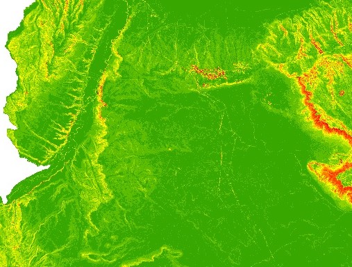
Pic1_not recls
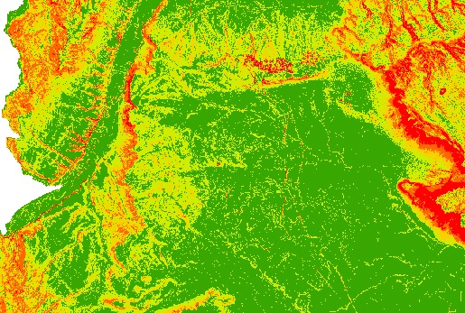
Pic2_reclas