- Home
- :
- All Communities
- :
- Products
- :
- ArcGIS Spatial Analyst
- :
- ArcGIS Spatial Analyst Questions
- :
- How to rank pixel values from multiple rasters in ...
- Subscribe to RSS Feed
- Mark Topic as New
- Mark Topic as Read
- Float this Topic for Current User
- Bookmark
- Subscribe
- Mute
- Printer Friendly Page
How to rank pixel values from multiple rasters in ArcGIS Pro with Python
- Mark as New
- Bookmark
- Subscribe
- Mute
- Subscribe to RSS Feed
- Permalink
Hi,
I have a stack of 20 ecosystem service rasters (values from 0 to 1) and I want to derive a ranked list of values from the stack when clicking on a pixel. Any ideas or recommendations? I am a newbee in Python, and would like to use the python code as a parametric tool in modelbuilder.
Best regards,
Frank
- Mark as New
- Bookmark
- Subscribe
- Mute
- Subscribe to RSS Feed
- Permalink
I think you may be underestimating the dimensionality of the problem, to pre-calculate this information per cell with a script tool would require cranking through an awful lot of data, it sounds like what you would want to do would require a sort of 20 values for every pixel, for an 1000x1000 x20 raster that's 20 million sorts. Unless I'm not understanding what you are asking for in your brief description.
- Mark as New
- Bookmark
- Subscribe
- Mute
- Subscribe to RSS Feed
- Permalink
What I meant was to rank and list 20 values for a spesific pixel by clicking on it
Skaff deg Outlook for Android<https://aka.ms/ghei36>
- Mark as New
- Bookmark
- Subscribe
- Mute
- Subscribe to RSS Feed
- Permalink
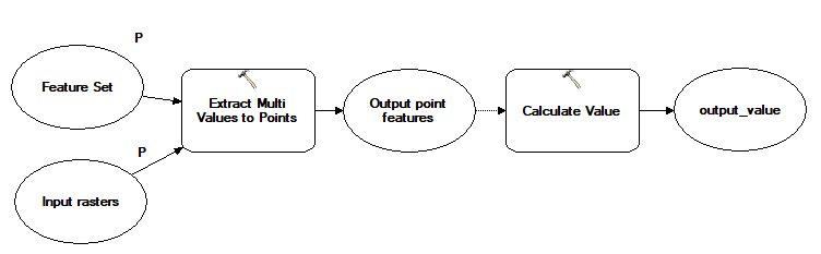
Something along the lines of this, with the Feature Set linked to a point feature class as a tempalte, and Calculate Value populated with a python function to read results from the table, sort, and return a formatted result, should do the trick.
- Mark as New
- Bookmark
- Subscribe
- Mute
- Subscribe to RSS Feed
- Permalink
Thanks a lot! I will check it out?
Skaff deg Outlook for Android<https://aka.ms/ghei36>