Turn on suggestions
Auto-suggest helps you quickly narrow down your search results by suggesting possible matches as you type.
Cancel
- Home
- :
- All Communities
- :
- Products
- :
- ArcGIS Spatial Analyst
- :
- ArcGIS Spatial Analyst Questions
- :
- How to combine these three rasters according to th...
Options
- Subscribe to RSS Feed
- Mark Topic as New
- Mark Topic as Read
- Float this Topic for Current User
- Bookmark
- Subscribe
- Mute
- Printer Friendly Page
How to combine these three rasters according to this logic?
Subscribe
2465
3
05-25-2011 12:25 AM
by
Anonymous User
Not applicable
05-25-2011
12:25 AM
- Mark as New
- Bookmark
- Subscribe
- Mute
- Subscribe to RSS Feed
- Permalink
Original User: [email protected]
How to combine these three rasters according to this logic?
please, see the attached images that show my question
explanation:
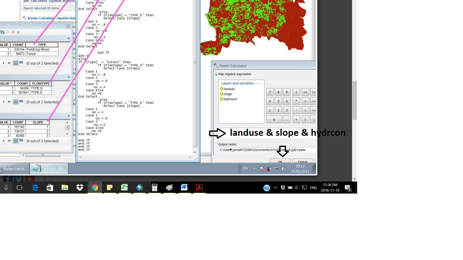
I've three rasters: slope, landuse and hydraulic conductivity. i need to combine them according the relation shown in the table (second attachment)
i convert the table shown in the second attachment to the following code:
-----------------------------------------------------------
if [Type] = "FieldCrop-Shrub" then
if [FlowType] = "TYPE D" then
Select Case [Slope]
Case 1
oo = .6
Case 2
oo =.4
Case 3
oo =.2
Case Else
oo =0
End Select
else
if [FlowType] = "TYPE E" then
Select Case [Slope]
Case 1
oo = .8
Case 2
oo =.6
Case 3
oo =.4
Case Else
oo =0
End Select
end if
end if
else
if [Type] = "Forest" then
if [FlowType] = "TYPE D" then
Select Case [Slope]
Case 1
oo = .8
Case 2
oo =.6
Case 3
oo =.4
Case Else
oo =0
End Select
else
if [FlowType] = "TYPE E" then
Select Case [Slope]
Case 1
oo = 1
Case 2
oo =.6
Case 3
oo =.4
Case Else
oo =0
End Select
end if
end if
end if
end if
---------------------------------------------------------------------------
Now, how can i include this code to combine these three rasters?
thank you
regards
Jamal
How to combine these three rasters according to this logic?
please, see the attached images that show my question
explanation:
I've three rasters: slope, landuse and hydraulic conductivity. i need to combine them according the relation shown in the table (second attachment)
i convert the table shown in the second attachment to the following code:
-----------------------------------------------------------
if [Type] = "FieldCrop-Shrub" then
if [FlowType] = "TYPE D" then
Select Case [Slope]
Case 1
oo = .6
Case 2
oo =.4
Case 3
oo =.2
Case Else
oo =0
End Select
else
if [FlowType] = "TYPE E" then
Select Case [Slope]
Case 1
oo = .8
Case 2
oo =.6
Case 3
oo =.4
Case Else
oo =0
End Select
end if
end if
else
if [Type] = "Forest" then
if [FlowType] = "TYPE D" then
Select Case [Slope]
Case 1
oo = .8
Case 2
oo =.6
Case 3
oo =.4
Case Else
oo =0
End Select
else
if [FlowType] = "TYPE E" then
Select Case [Slope]
Case 1
oo = 1
Case 2
oo =.6
Case 3
oo =.4
Case Else
oo =0
End Select
end if
end if
end if
end if
---------------------------------------------------------------------------
Now, how can i include this code to combine these three rasters?
thank you
regards
Jamal
3 Replies
11-08-2016
01:33 PM
- Mark as New
- Bookmark
- Subscribe
- Mute
- Subscribe to RSS Feed
- Permalink
I know this is an old thread, but it popped up to the top, so here's a quick answer. The equivalent of if/then/else logic for rasters is the Con tool/statement.
Con(condition,do this if true, do this if false)
11-15-2016
09:11 AM
- Mark as New
- Bookmark
- Subscribe
- Mute
- Subscribe to RSS Feed
- Permalink
As an alternative one could use the Combine—Help | ArcGIS for Desktop tool to combine the rasters (have to be integer) and perform the analysis in the attribute table (create a new field with the result) and use the Lookup—Help | ArcGIS for Desktop tool to create the output raster based on the generated field.