- Home
- :
- All Communities
- :
- Products
- :
- ArcGIS Spatial Analyst
- :
- ArcGIS Spatial Analyst Questions
- :
- How do I figure out elevation statistics around ea...
- Subscribe to RSS Feed
- Mark Topic as New
- Mark Topic as Read
- Float this Topic for Current User
- Bookmark
- Subscribe
- Mute
- Printer Friendly Page
How do I figure out elevation statistics around each point?
- Mark as New
- Bookmark
- Subscribe
- Mute
- Subscribe to RSS Feed
- Permalink
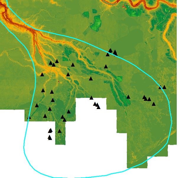
Hi! I would like to obtain some data from the image above - I would like to know the distribution of elevations around each of the black triangles shown above - perhaps within a radius of 15 meters of each point?
Can anyone help me figure out how to do this? I particularly want to know the highest elevations, the lowest elevations, the avg. elevation, and modal elevations around each of these points.
- Mark as New
- Bookmark
- Subscribe
- Mute
- Subscribe to RSS Feed
- Permalink
Thanks Dan! Can you please also tell me how to buffer each of my points by 15 meters?
- Mark as New
- Bookmark
- Subscribe
- Mute
- Subscribe to RSS Feed
- Permalink
Yes, you use the Buffer tool in Arctoolbox but you want to make sure you are using projected data or you have your data in a projected data frame to ensure that your buffer distances are in meters and not in decimal degrees.
- Mark as New
- Bookmark
- Subscribe
- Mute
- Subscribe to RSS Feed
- Permalink
you could also use Focal Statistics