- Home
- :
- All Communities
- :
- Products
- :
- ArcGIS Spatial Analyst
- :
- ArcGIS Spatial Analyst Questions
- :
- Re: How do I calculate cost distance?
- Subscribe to RSS Feed
- Mark Topic as New
- Mark Topic as Read
- Float this Topic for Current User
- Bookmark
- Subscribe
- Mute
- Printer Friendly Page
How do I calculate cost distance?
- Mark as New
- Bookmark
- Subscribe
- Mute
- Subscribe to RSS Feed
- Permalink
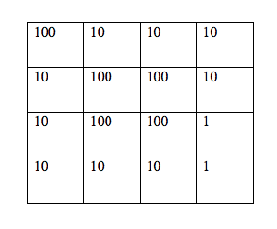
I know this is probably pretty basic, but i'm a student and can't get it right. I'm looking at this chart with several boxes and i'm supposed to estimate the cheapest costs and paths. I've looked at the examples but can't get it to come out right. All I need is a little nudge in the right direction so I know what i'm doing.
Thanks. 
- Mark as New
- Bookmark
- Subscribe
- Mute
- Subscribe to RSS Feed
- Permalink
How cost distance tools work—ArcGIS Pro | Documentation
then the legacy toolset
Understanding cost distance analysis—ArcGIS Pro | Documentation
then the actual tools
Cost Distance (Spatial Analyst)—ArcGIS Pro | Documentation
... sort of retired...
- Mark as New
- Bookmark
- Subscribe
- Mute
- Subscribe to RSS Feed
- Permalink
Thank you! I've read these but there's no information on exactly how to calculate it. They say to use the Pythagoras theorem. I know how to use it, but what values? The values in the boxes (10, 100, etc.) or the amount of steps I take?
If I start in the upper right cell (value 10) and I go two steps down, and one step to the left. I will end up at 100. Where do I go from here?