- Home
- :
- All Communities
- :
- Products
- :
- ArcGIS Spatial Analyst
- :
- ArcGIS Spatial Analyst Questions
- :
- How do I bring in an ArcGIS ascii grid file so tha...
- Subscribe to RSS Feed
- Mark Topic as New
- Mark Topic as Read
- Float this Topic for Current User
- Bookmark
- Subscribe
- Mute
- Printer Friendly Page
How do I bring in an ArcGIS ascii grid file so that it is visible with a map of North America?
- Mark as New
- Bookmark
- Subscribe
- Mute
- Subscribe to RSS Feed
- Permalink
I have an ascii grid file containing some air quality data over the North American region. I've already brought in boundary shape files for Mexico, the US, and Canada so that the grid file can hopefully adopt their projection (NAD 1983). The grid file:
- extends from 10.0N/-200.0W to 76.0N/-62.0W
- has 460 columns and 220 rows
- has a cell size of 0.3 degrees
I've written a header like this:
NCOLS 460
NROWS 220
XLLCENTER 10.15
YLLCENTER -199.85
CELLSIZE 0.3
NODATA_VALUE -999
I'm attempting to bring the grid file in using the ASCII to Raster tool and then use the the define projection tool to define a NAD 1983 projection (ArcGIS) insists in bringing in the data without a projection. Once this is done I can see one or the other, but not what I should see: the ascii data displayed over North America. I'm kind of at my wit's end!!!! Can I get some ideas of how I should be doing this? Thanks VERY MUCH in advance for your help!!
Solved! Go to Solution.
Accepted Solutions
- Mark as New
- Bookmark
- Subscribe
- Mute
- Subscribe to RSS Feed
- Permalink
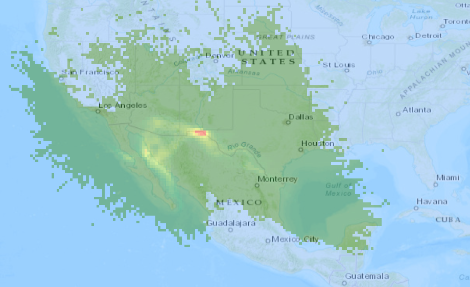
If you switch the XLL and YLL values in the header and set the coordinate system to WGS1984 before you load the raster, it will look like this:
- Mark as New
- Bookmark
- Subscribe
- Mute
- Subscribe to RSS Feed
- Permalink
That would be a Geographic Coordinate System (GCS)?
460 columns * 0.3 degs per column relative to the XLL of -199.85 (weird to begin with)
would put the lower left at -61.85 degrees, sound right? (I don't think so)
Where did you get this file?
- Mark as New
- Bookmark
- Subscribe
- Mute
- Subscribe to RSS Feed
- Permalink
If you switch the XLL and YLL values in the header and set the coordinate system to WGS1984 before you load the raster, it will look like this: