- Home
- :
- All Communities
- :
- Products
- :
- ArcGIS Spatial Analyst
- :
- ArcGIS Spatial Analyst Questions
- :
- Extracting data within polygon shapefile
- Subscribe to RSS Feed
- Mark Topic as New
- Mark Topic as Read
- Float this Topic for Current User
- Bookmark
- Subscribe
- Mute
- Printer Friendly Page
- Mark as New
- Bookmark
- Subscribe
- Mute
- Subscribe to RSS Feed
- Permalink
Hello,
I am trying to determine the percentage of each type of land use within delineated sub-basins. The land use data is in a shape file and the land use types are coded 1-15 and the sub-basins are in a polygon shape file. Is there a way to determine this? I have tried merge, union, join, relate. tabulate area under the zonal spatial analyst tools, etc. The most promising appeared to be the tabulate area tool, but the areas that come out are in unrecognizable units so it is difficult to back check for accuracy.
I would like to have a end result that shows something like:
Area ID Total Area (ac) LU1 (ac) LU2 (ac) LU3 (ac) etc.
Area 1 3.25 0.27 1.64 0.11
Area 2 1.52 0.33 0.57 0.29
Area 3 5.87 0.98 1.64 2.00
etc.
Thanks in advance for your help!
Solved! Go to Solution.
Accepted Solutions
- Mark as New
- Bookmark
- Subscribe
- Mute
- Subscribe to RSS Feed
- Permalink
Here is a straight-forward way to do this calculation using only vector feature classes:
1.) Add a new field and calculate the total area for each sub-basin
2.) Intersect the sub-basins with land use. If you have advanced licensing, the ideal tool would be Identity, to guarantee that your final sub-basins add to 100%. With Intersect, if your land uses do not entirely cover the sub-basins, the final total percents will be less than 100%, but if they are covered Intersect will work fine.
3.) Add a new field and calculate the area of the intersected polygons
4.) Use Summary Statistics or Dissolve to sum the areas, group by land use and sub-basin ID
This will result in more of a list than the desired grid, so additional formatting may be required.
- Mark as New
- Bookmark
- Subscribe
- Mute
- Subscribe to RSS Feed
- Permalink
If the areas are in unrecognizable units...my guess is that you are working with unprojected data...aka those pesky decimal degree coordinates... You could try projecting the files and trying again which would give you units in meters (assuming a projection that is in meters, like, utm, albers, lambert, state plane and most others)
But more likely, you have at least one layer which is raster, hence, you should again have a raster that is projected and the count field represents the number of cells of a certain area (cell size**2 to get area per cell). In the spatial analyst extension, there are a variety of other options which can be pursued..
As you indicate Tabulate Area—Help | ArcGIS for Desktop is one option, but have a look a these as well
Zonal Statistics—Help | ArcGIS for Desktop
Zonal Statistics as Table—Help | ArcGIS for Desktop
and this if you need to combine two layers.
Combine—Help | ArcGIS for Desktop
PS if one of the files is a shapefile, then you can convert it to a raster...since you should use the same cell size, extent and snap raster as the file you are trying to summarize.
- Mark as New
- Bookmark
- Subscribe
- Mute
- Subscribe to RSS Feed
- Permalink
No, they are all on the same projected coordinate system, NAD_1983_StatePlane_Louisiana_South_FIPS_1702_Feet.
None of the layers are rasters. The land use raster was converted to a polygon shape file prior to trying the tabulate area command.
- Mark as New
- Bookmark
- Subscribe
- Mute
- Subscribe to RSS Feed
- Permalink
Becky
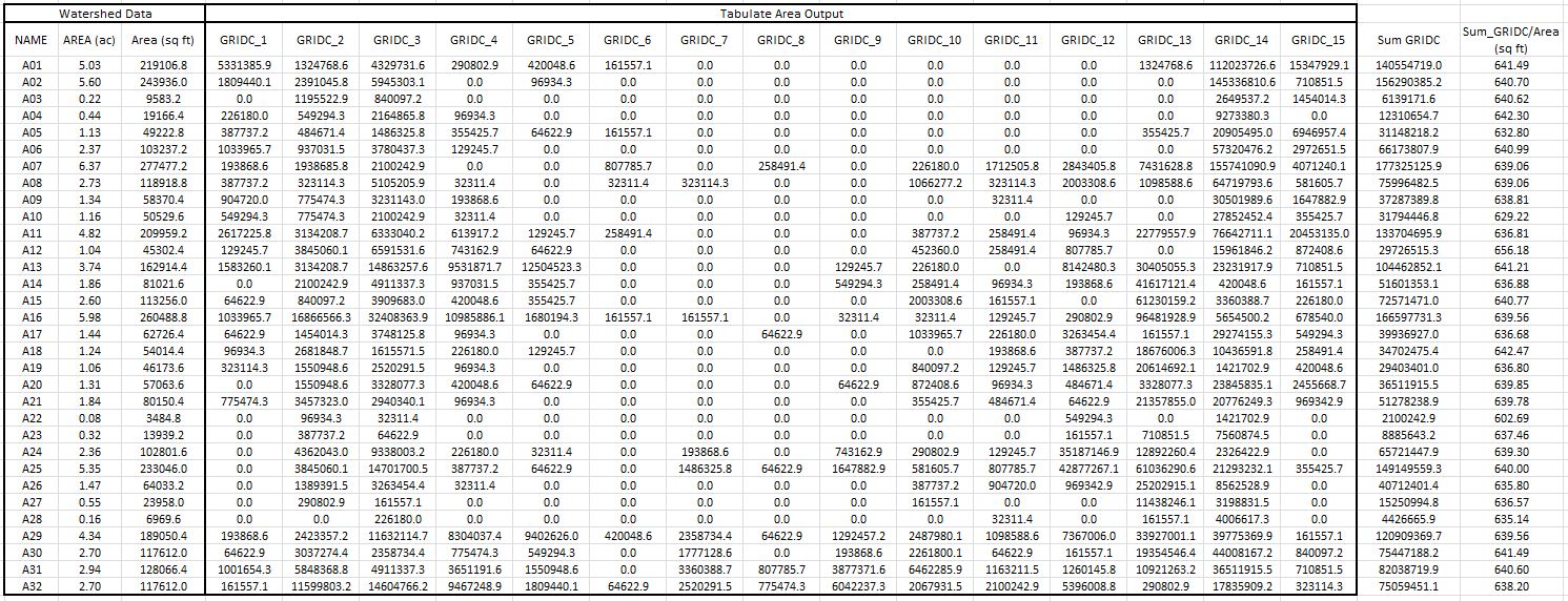
Can you post an image or at least the units that it was returning? I would expect them to be in feet squared...which you will have to convert to square miles or whatever suits you.
Since you had a raster already, did you not try the spatial analyst tools options?
- Mark as New
- Bookmark
- Subscribe
- Mute
- Subscribe to RSS Feed
- Permalink
Well SumGridC/area makes no sense. the sum of the grid cells is the number of cells...what you need to do now is divide that sum by the cell area...so if you have know what the cell area is (cell size squared, since cell size is reported as width, not area)
- Mark as New
- Bookmark
- Subscribe
- Mute
- Subscribe to RSS Feed
- Permalink
Here is a straight-forward way to do this calculation using only vector feature classes:
1.) Add a new field and calculate the total area for each sub-basin
2.) Intersect the sub-basins with land use. If you have advanced licensing, the ideal tool would be Identity, to guarantee that your final sub-basins add to 100%. With Intersect, if your land uses do not entirely cover the sub-basins, the final total percents will be less than 100%, but if they are covered Intersect will work fine.
3.) Add a new field and calculate the area of the intersected polygons
4.) Use Summary Statistics or Dissolve to sum the areas, group by land use and sub-basin ID
This will result in more of a list than the desired grid, so additional formatting may be required.
- Mark as New
- Bookmark
- Subscribe
- Mute
- Subscribe to RSS Feed
- Permalink
This sounds like what I want to do. What license do I need to use Identify? I currently only see Intersect, Spatial Join, and Union under Analysis Tools -> Overlay.
- Mark as New
- Bookmark
- Subscribe
- Mute
- Subscribe to RSS Feed
- Permalink
Advanced...
for all tools, scroll to the bottom of its help topic and rejoice or weep depending on your level
- Mark as New
- Bookmark
- Subscribe
- Mute
- Subscribe to RSS Feed
- Permalink
You likely have basic licensing. Intersect should work - just be aware that it will only return the areas that are covered by both a sub-basin and a land use polygon. It can be an issue if, for example, one of the sub-basins is only covered 50% by land use, and then the summed percents will not add to 100%, but as long as you know what you're getting into, it's not a problem.