- Home
- :
- All Communities
- :
- Products
- :
- ArcGIS Spatial Analyst
- :
- ArcGIS Spatial Analyst Questions
- :
- errors on performing "cell statistics" (error 9999...
- Subscribe to RSS Feed
- Mark Topic as New
- Mark Topic as Read
- Float this Topic for Current User
- Bookmark
- Subscribe
- Mute
- Printer Friendly Page
errors on performing "cell statistics" (error 99999) or "raster calculator" (000539) on 27 rasters
- Mark as New
- Bookmark
- Subscribe
- Mute
- Subscribe to RSS Feed
- Permalink
Hi, I need to do some statistics (mean, std) in order to compare each cell of 27 rasters. I get error using "cell statistics" (error 99999) or "raster calculator" (000539). Any ideas where come from the error (my formula in raster calculator has been rechecked and it is correct).
- Mark as New
- Bookmark
- Subscribe
- Mute
- Subscribe to RSS Feed
- Permalink
perhaps you could provide it anyway, but things to check when working with rasters would include
- file paths with spaces
- files in different coordinate systems
- mismatched cell sizes, extents and/or alignment can cause problems when they are attempted to be accounted for on the fly
- not saving a raster with a *.tif file extension produces an esri grid, which raises a whole different set of concerns
- data sources sometimes on servers have caused issues which are resolved when working with locally stored data
the 99999xxxx errors are generic errors, suggesting there is no specific category of error but potentially many errors or one that doesn't fit nicely into a 'mistake'
Also, version of arcmap and/or Pro
- Mark as New
- Bookmark
- Subscribe
- Mute
- Subscribe to RSS Feed
- Permalink
Error 000539... some from the ESRI support home
- Mark as New
- Bookmark
- Subscribe
- Mute
- Subscribe to RSS Feed
- Permalink
Thank you very much for your advice. Unfortunetaly, all rasters seem to have appropriate configuration (the 27 rasters have been created in modelbuider using cell statistics and raster calculation tools from the same initial parameter and I did not get any issue....all file path have no space, I working on my internal hardrive only). The error comes from somewhere else.
- Mark as New
- Bookmark
- Subscribe
- Mute
- Subscribe to RSS Feed
- Permalink
Please copy and paste your tool messages into the thread, this may shed some light as to what is going on. It really is hard to suggest a fix without more information.
That said, another thing to look for is to make sure your workspace and scratch workspace environments are set to a valid path.
- Mark as New
- Bookmark
- Subscribe
- Mute
- Subscribe to RSS Feed
- Permalink
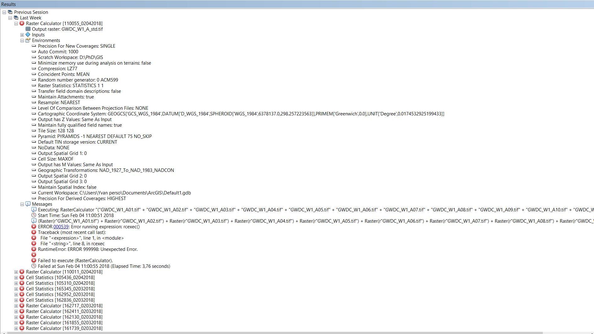
See the screen shot of both error. I never change the current workspace since I installed ARCGIS (and i did not get any issue with it) but I get sure that the scratch workspace doesnt have space. My raster caculator expression is the simple mean calculation as below (as raster statistics was not working I try raster calculator but I test with mean while I am more interested with std)
("GWDC_W1_A01.tif" + "GWDC_W1_A02.tif" + "GWDC_W1_A03.tif" + "GWDC_W1_A04.tif" + "GWDC_W1_A05.tif" + "GWDC_W1_A06.tif" + "GWDC_W1_A07.tif" + "GWDC_W1_A08.tif" + "GWDC_W1_A09.tif" + "GWDC_W1_A10.tif" + "GWDC_W1_A11.tif" + "GWDC_W1_A12.tif" + "GWDC_W1_A13.tif" + "GWDC_W1_A14.tif" + "GWDC_W1_A15.tif" + "GWDC_W1_A16.tif" + "GWDC_W1_A17.tif" + "GWDC_W1_A18.tif" + "GWDC_W1_A19.tif" + "GWDC_W1_A20.tif" + "GWDC_W1_A21.tif" + "GWDC_W1_A22.tif" + "GWDC_W1_A23.tif" + "GWDC_W1_A24.tif" + "GWDC_W1_A25.tif" + "GWDC_W1_A26.tif" + "GWDC_W1_A27.tif") / 27
- Mark as New
- Bookmark
- Subscribe
- Mute
- Subscribe to RSS Feed
- Permalink
If you chop it up in three parts of 9 rasters does any of the expressions in the Raster calculator or using Cell Statistics run correctly? It might be related to 1 or more rasters?
Can you try to run these calculations and see if any one works:
("GWDC_W1_A01.tif" + "GWDC_W1_A02.tif" + "GWDC_W1_A03.tif" + "GWDC_W1_A04.tif" + "GWDC_W1_A05.tif" + "GWDC_W1_A06.tif" + "GWDC_W1_A07.tif" + "GWDC_W1_A08.tif" + "GWDC_W1_A09.tif") / 9
("GWDC_W1_A10.tif" + "GWDC_W1_A11.tif" + "GWDC_W1_A12.tif" + "GWDC_W1_A13.tif" + "GWDC_W1_A14.tif" + "GWDC_W1_A15.tif" + "GWDC_W1_A16.tif" + "GWDC_W1_A17.tif" + "GWDC_W1_A18.tif") / 9
("GWDC_W1_A19.tif" + "GWDC_W1_A20.tif" + "GWDC_W1_A21.tif" + "GWDC_W1_A22.tif" + "GWDC_W1_A23.tif" + "GWDC_W1_A24.tif" + "GWDC_W1_A25.tif" + "GWDC_W1_A26.tif" + "GWDC_W1_A27.tif") / 9If they do, you can finish by calculating the mean of the 3 resulting rasters.
Some other questions:
- What range of values do the rasters have?
- What pixel type do they have?
- Do the have NoData cells?
Try as Dan suggested earlier to use a proprietary data format (such as FGDB raster) to see if the problem continues. If possible share the rasters to this thread so we can investigate a little more to find out what the possible reason for the error might be.
- Mark as New
- Bookmark
- Subscribe
- Mute
- Subscribe to RSS Feed
- Permalink
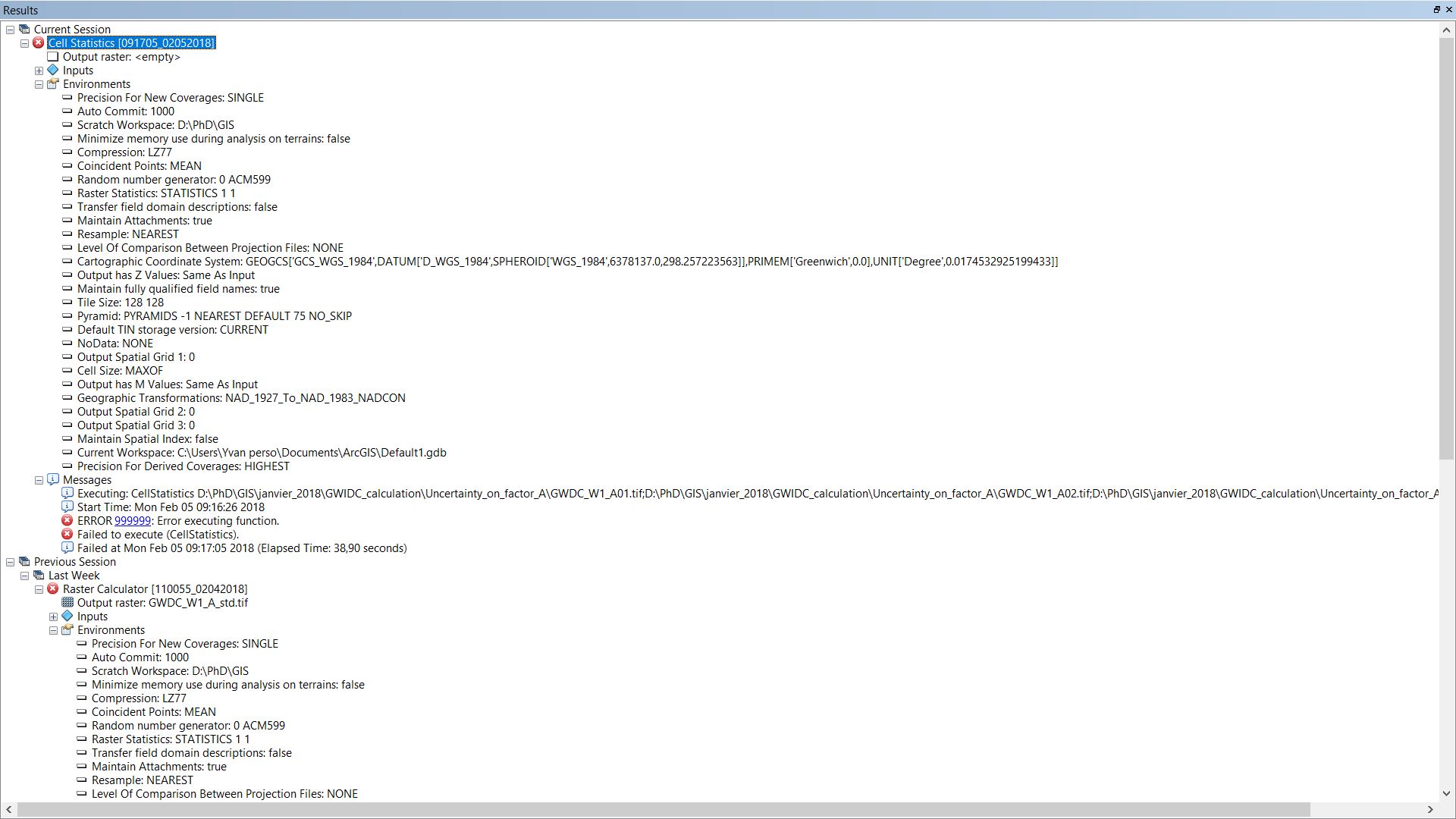
Hi, thanks. The cell statitics is working if I am splitting into 3 group ou 2 group the 27 rasters (but I have to open a new map document for making it working) but it doesnt work with the 27 rasters.
- Mark as New
- Bookmark
- Subscribe
- Mute
- Subscribe to RSS Feed
- Permalink
Share your raster calculator expression or your modelbuilder script export if you can.
- Mark as New
- Bookmark
- Subscribe
- Mute
- Subscribe to RSS Feed
- Permalink
Hi see below the script export of the modelbuilder. Thanks
# -*- coding: utf-8 -*-
# ---------------------------------------------------------------------------
# statistics.py
# Created on: 2018-02-06 10:09:49.00000
# (generated by ArcGIS/ModelBuilder)
# Description:
# ---------------------------------------------------------------------------
# Import arcpy module
import arcpy
# Local variables:
GWDC_W1_A01_tif = "D:\\PhD\\GIS\\janvier_2018\\GWIDC_calculation\\Uncertainty_on_factor_A\\GWDC_W1_A01.tif"
GWDC_W1_A02_tif = "D:\\PhD\\GIS\\janvier_2018\\GWIDC_calculation\\Uncertainty_on_factor_A\\GWDC_W1_A02.tif"
GWDC_W1_A03_tif = "D:\\PhD\\GIS\\janvier_2018\\GWIDC_calculation\\Uncertainty_on_factor_A\\GWDC_W1_A03.tif"
GWDC_W1_A04_tif = "D:\\PhD\\GIS\\janvier_2018\\GWIDC_calculation\\Uncertainty_on_factor_A\\GWDC_W1_A04.tif"
GWDC_W1_A05_tif = "D:\\PhD\\GIS\\janvier_2018\\GWIDC_calculation\\Uncertainty_on_factor_A\\GWDC_W1_A05.tif"
GWDC_W1_A06_tif = "D:\\PhD\\GIS\\janvier_2018\\GWIDC_calculation\\Uncertainty_on_factor_A\\GWDC_W1_A06.tif"
GWDC_W1_A07_tif = "D:\\PhD\\GIS\\janvier_2018\\GWIDC_calculation\\Uncertainty_on_factor_A\\GWDC_W1_A07.tif"
GWDC_W1_A08_tif = "D:\\PhD\\GIS\\janvier_2018\\GWIDC_calculation\\Uncertainty_on_factor_A\\GWDC_W1_A08.tif"
GWDC_W1_A09_tif = "D:\\PhD\\GIS\\janvier_2018\\GWIDC_calculation\\Uncertainty_on_factor_A\\GWDC_W1_A09.tif"
GWDC_W1_A10_tif = "D:\\PhD\\GIS\\janvier_2018\\GWIDC_calculation\\Uncertainty_on_factor_A\\GWDC_W1_A10.tif"
GWDC_W1_A11_tif = "D:\\PhD\\GIS\\janvier_2018\\GWIDC_calculation\\Uncertainty_on_factor_A\\GWDC_W1_A11.tif"
GWDC_W1_A12_tif = "D:\\PhD\\GIS\\janvier_2018\\GWIDC_calculation\\Uncertainty_on_factor_A\\GWDC_W1_A12.tif"
GWDC_W1_A13_tif = "D:\\PhD\\GIS\\janvier_2018\\GWIDC_calculation\\Uncertainty_on_factor_A\\GWDC_W1_A13.tif"
GWDC_W1_A14_tif = "D:\\PhD\\GIS\\janvier_2018\\GWIDC_calculation\\Uncertainty_on_factor_A\\GWDC_W1_A14.tif"
GWDC_W1_A15_tif = "D:\\PhD\\GIS\\janvier_2018\\GWIDC_calculation\\Uncertainty_on_factor_A\\GWDC_W1_A15.tif"
GWDC_W1_A16_tif = "D:\\PhD\\GIS\\janvier_2018\\GWIDC_calculation\\Uncertainty_on_factor_A\\GWDC_W1_A16.tif"
GWDC_W1_A17_tif = "D:\\PhD\\GIS\\janvier_2018\\GWIDC_calculation\\Uncertainty_on_factor_A\\GWDC_W1_A17.tif"
GWDC_W1_A18_tif = "D:\\PhD\\GIS\\janvier_2018\\GWIDC_calculation\\Uncertainty_on_factor_A\\GWDC_W1_A18.tif"
GWDC_W1_A19_tif = "D:\\PhD\\GIS\\janvier_2018\\GWIDC_calculation\\Uncertainty_on_factor_A\\GWDC_W1_A19.tif"
GWDC_W1_A20_tif = "D:\\PhD\\GIS\\janvier_2018\\GWIDC_calculation\\Uncertainty_on_factor_A\\GWDC_W1_A20.tif"
GWDC_W1_A21_tif = "D:\\PhD\\GIS\\janvier_2018\\GWIDC_calculation\\Uncertainty_on_factor_A\\GWDC_W1_A21.tif"
GWDC_W1_A22_tif = "D:\\PhD\\GIS\\janvier_2018\\GWIDC_calculation\\Uncertainty_on_factor_A\\GWDC_W1_A22.tif"
GWDC_W1_A23_tif = "D:\\PhD\\GIS\\janvier_2018\\GWIDC_calculation\\Uncertainty_on_factor_A\\GWDC_W1_A23.tif"
GWDC_W1_A24_tif = "D:\\PhD\\GIS\\janvier_2018\\GWIDC_calculation\\Uncertainty_on_factor_A\\GWDC_W1_A24.tif"
GWDC_W1_A25_tif = "D:\\PhD\\GIS\\janvier_2018\\GWIDC_calculation\\Uncertainty_on_factor_A\\GWDC_W1_A25.tif"
GWDC_W1_A26_tif = "D:\\PhD\\GIS\\janvier_2018\\GWIDC_calculation\\Uncertainty_on_factor_A\\GWDC_W1_A26.tif"
GWDC_W1_A27_tif = "D:\\PhD\\GIS\\janvier_2018\\GWIDC_calculation\\Uncertainty_on_factor_A\\GWDC_W1_A27.tif"
GWDC_W1_A_std_tif = "D:\\PhD\\GIS\\janvier_2018\\GWIDC_calculation\\Uncertainty_on_factor_A\\GWDC_W1_A_std.tif"
# Process: Cell Statistics
arcpy.gp.CellStatistics_sa("D:\\PhD\\GIS\\janvier_2018\\GWIDC_calculation\\Uncertainty_on_factor_A\\GWDC_W1_A01.tif;D:\\PhD\\GIS\\janvier_2018\\GWIDC_calculation\\Uncertainty_on_factor_A\\GWDC_W1_A02.tif;D:\\PhD\\GIS\\janvier_2018\\GWIDC_calculation\\Uncertainty_on_factor_A\\GWDC_W1_A03.tif;D:\\PhD\\GIS\\janvier_2018\\GWIDC_calculation\\Uncertainty_on_factor_A\\GWDC_W1_A04.tif;D:\\PhD\\GIS\\janvier_2018\\GWIDC_calculation\\Uncertainty_on_factor_A\\GWDC_W1_A05.tif;D:\\PhD\\GIS\\janvier_2018\\GWIDC_calculation\\Uncertainty_on_factor_A\\GWDC_W1_A06.tif;D:\\PhD\\GIS\\janvier_2018\\GWIDC_calculation\\Uncertainty_on_factor_A\\GWDC_W1_A07.tif;D:\\PhD\\GIS\\janvier_2018\\GWIDC_calculation\\Uncertainty_on_factor_A\\GWDC_W1_A08.tif;D:\\PhD\\GIS\\janvier_2018\\GWIDC_calculation\\Uncertainty_on_factor_A\\GWDC_W1_A09.tif;D:\\PhD\\GIS\\janvier_2018\\GWIDC_calculation\\Uncertainty_on_factor_A\\GWDC_W1_A10.tif;D:\\PhD\\GIS\\janvier_2018\\GWIDC_calculation\\Uncertainty_on_factor_A\\GWDC_W1_A11.tif;D:\\PhD\\GIS\\janvier_2018\\GWIDC_calculation\\Uncertainty_on_factor_A\\GWDC_W1_A12.tif;D:\\PhD\\GIS\\janvier_2018\\GWIDC_calculation\\Uncertainty_on_factor_A\\GWDC_W1_A13.tif;D:\\PhD\\GIS\\janvier_2018\\GWIDC_calculation\\Uncertainty_on_factor_A\\GWDC_W1_A14.tif;D:\\PhD\\GIS\\janvier_2018\\GWIDC_calculation\\Uncertainty_on_factor_A\\GWDC_W1_A15.tif;D:\\PhD\\GIS\\janvier_2018\\GWIDC_calculation\\Uncertainty_on_factor_A\\GWDC_W1_A16.tif;D:\\PhD\\GIS\\janvier_2018\\GWIDC_calculation\\Uncertainty_on_factor_A\\GWDC_W1_A17.tif;D:\\PhD\\GIS\\janvier_2018\\GWIDC_calculation\\Uncertainty_on_factor_A\\GWDC_W1_A18.tif;D:\\PhD\\GIS\\janvier_2018\\GWIDC_calculation\\Uncertainty_on_factor_A\\GWDC_W1_A19.tif;D:\\PhD\\GIS\\janvier_2018\\GWIDC_calculation\\Uncertainty_on_factor_A\\GWDC_W1_A20.tif;D:\\PhD\\GIS\\janvier_2018\\GWIDC_calculation\\Uncertainty_on_factor_A\\GWDC_W1_A21.tif;D:\\PhD\\GIS\\janvier_2018\\GWIDC_calculation\\Uncertainty_on_factor_A\\GWDC_W1_A22.tif;D:\\PhD\\GIS\\janvier_2018\\GWIDC_calculation\\Uncertainty_on_factor_A\\GWDC_W1_A23.tif;D:\\PhD\\GIS\\janvier_2018\\GWIDC_calculation\\Uncertainty_on_factor_A\\GWDC_W1_A24.tif;D:\\PhD\\GIS\\janvier_2018\\GWIDC_calculation\\Uncertainty_on_factor_A\\GWDC_W1_A25.tif;D:\\PhD\\GIS\\janvier_2018\\GWIDC_calculation\\Uncertainty_on_factor_A\\GWDC_W1_A26.tif;D:\\PhD\\GIS\\janvier_2018\\GWIDC_calculation\\Uncertainty_on_factor_A\\GWDC_W1_A27.tif", GWDC_W1_A_std_tif, "STD", "DATA")