- Home
- :
- All Communities
- :
- Products
- :
- ArcGIS Spatial Analyst
- :
- ArcGIS Spatial Analyst Questions
- :
- Creating Heatmap from attribute value of point fea...
- Subscribe to RSS Feed
- Mark Topic as New
- Mark Topic as Read
- Float this Topic for Current User
- Bookmark
- Subscribe
- Mute
- Printer Friendly Page
Creating Heatmap from attribute value of point features in ArcGIS for Desktop?
- Mark as New
- Bookmark
- Subscribe
- Mute
- Subscribe to RSS Feed
- Permalink
I've run through tutorial from ArcGIS on how to create a heat map using Spatial Analysis.
Based on the example, point features are scattered around the map and we need do the following to generate heat map.
Run Project Data -> Integrate Data -> Collect Events -> Run "Hotspot Analysis" -> Run "Spatial Analysis"
Is it possible to generate a heat map if I don't have point features that are scattered around the map but instead I have point features that have an attribute value that represent "Number of point" around this point features?
For example: I have 5 locations.
In the first scenario, I will have
- 5 points feature around area #1
- 20 points feature around area #2
- 40 points feature around area #3
- 30 points feature around area #4
- 10 points feature around area #5
While for second scenario, I will have
- Point feature 1, attribute value: 5
- Point feature 2, attribute value: 20
- Point feature 3, attribute value: 40
- Point feature 4, attribute value: 30
- Point feature 5, attribute value: 10
Solved! Go to Solution.
Accepted Solutions
- Mark as New
- Bookmark
- Subscribe
- Mute
- Subscribe to RSS Feed
- Permalink
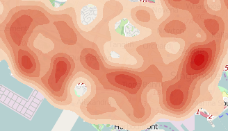
I managed to achieve the heat map I'm looking for using Kernel Density (Spatial Analysis) and use the respective attribute as a value for "Population Field".
- Mark as New
- Bookmark
- Subscribe
- Mute
- Subscribe to RSS Feed
- Permalink
Henri, you should mark your question as "assumed answered" since you were able to answer your own question. That will allow this thread to be closed. thanks.
- Mark as New
- Bookmark
- Subscribe
- Mute
- Subscribe to RSS Feed
- Permalink
You should also move this to a more appropriate space, such as GIS or Spatial Analyst, and use tags to help those searching on this subject in the future.