- Home
- :
- All Communities
- :
- Products
- :
- ArcGIS Spatial Analyst
- :
- ArcGIS Spatial Analyst Questions
- :
- Re: Could I create a raster depicting cells that a...
- Subscribe to RSS Feed
- Mark Topic as New
- Mark Topic as Read
- Float this Topic for Current User
- Bookmark
- Subscribe
- Mute
- Printer Friendly Page
Could I create a raster depicting cells that are visible from a road?
- Mark as New
- Bookmark
- Subscribe
- Mute
- Subscribe to RSS Feed
- Permalink
- Report Inappropriate Content
I have a 30m DEM raster and a polyline shapefile for a road network. I would like to produce a 30m raster of I/0 values showing whether or not each cell is visible from a road up to 2000m. I'd like to use a height of 2m above the road to represent the height of a commercial vehicle.
Is this possible with the viewshed tool? The examples I have found work best for smaller point shapefiles, like whether a tower is visible, and do not help for a large, polyline feature.
Thank you for any ideas!
- Mark as New
- Bookmark
- Subscribe
- Mute
- Subscribe to RSS Feed
- Permalink
- Report Inappropriate Content
Viewshed (and related tools) can take a polyline as input - there will just a be a trade-off between speed/storage and resolution depending on how dense you want the observation points along the line. For example, it may not be reasonable to calculate the viewshed every metre along a road, but every 100 m may work fine.
- Mark as New
- Bookmark
- Subscribe
- Mute
- Subscribe to RSS Feed
- Permalink
- Report Inappropriate Content
Viewshed limits are 16 points per test... so you have to batch and choose wisely
- Mark as New
- Bookmark
- Subscribe
- Mute
- Subscribe to RSS Feed
- Permalink
- Report Inappropriate Content
I can't test right now, but I only see that limitation for Observer Points, not Viewshed.
- Mark as New
- Bookmark
- Subscribe
- Mute
- Subscribe to RSS Feed
- Permalink
- Report Inappropriate Content
That would be the limit I refer to... If the interest is in just to see if the road is visible, it just needs to be elevated, it is usually the observer points that is the limitation, not what is being looked at. Convert the road to raster, a con could be used ... ie, if road, then elevation + 2m, otherwise elevation, then there is no issue, unless the landscape needs to be viewed from multiple locations
- Mark as New
- Bookmark
- Subscribe
- Mute
- Subscribe to RSS Feed
- Permalink
- Report Inappropriate Content
The way the problem is described, they want Viewshed in this case, so there shouldn't be an issue.
- Mark as New
- Bookmark
- Subscribe
- Mute
- Subscribe to RSS Feed
- Permalink
- Report Inappropriate Content
In 2012 (I cant recall which version of ArcMap, probably 10.1), I ran a Viewshed analysis on about 300 000 buildings and the process took 33 days to complete (805 hours)! So it is possible, it just computationally intensive. Last year I ran a Visibility analysis on 17 716 points (as Input Points) and the process took just under a week to complete. Both of these analysis used the 90m DEM as input.
So I would think you need to reduce your number of inputs so best to subsample as Darren suggested. There is a geoprocessing tool called Generate points along line that you can use to create points every 100 m or so. It may be a good idea to use topography to inform the distance values for certain areas (more hilly, more points) but the trade-off would be that it then complicates the number of times a cell is visible (if that is of importance).
- Mark as New
- Bookmark
- Subscribe
- Mute
- Subscribe to RSS Feed
- Permalink
- Report Inappropriate Content
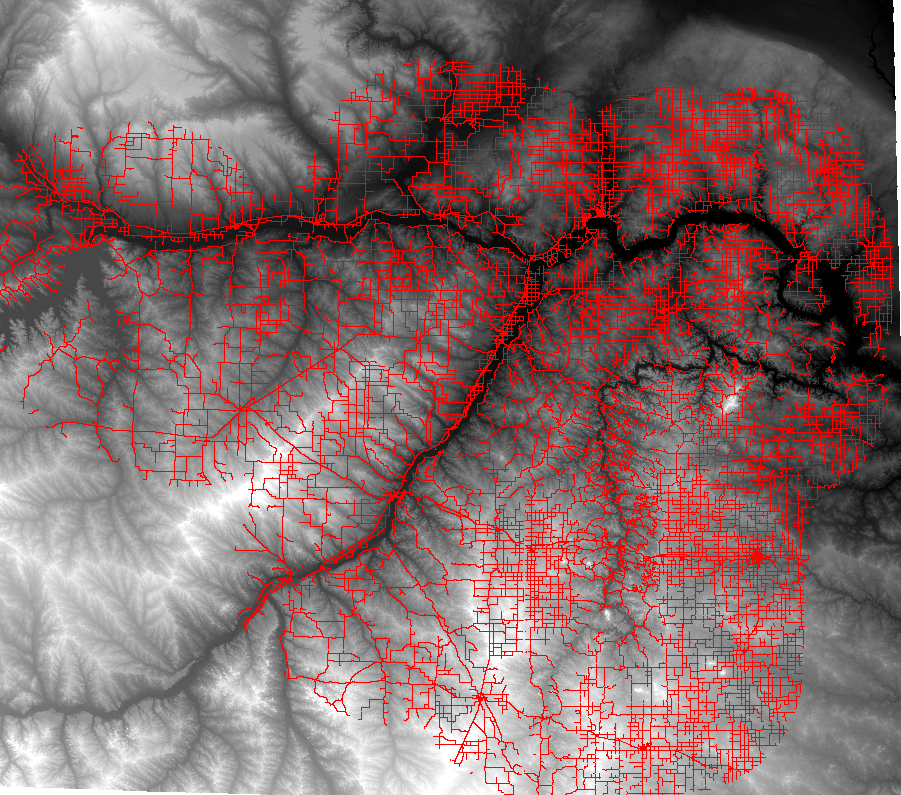
I am looking at a large area approximately 80x80 miles with an extensive road network (see attached, roads are clipped by a study area buffer). So I cannot use the observer option because of the 32 point limit on observers.
I am currently running the Visibility tool with the DEM as the input raster, and roads as the input polyline. Analysis type: FREQUENCY, observer parameters-- Surface offset: 2, Outer radius: 1600.
I thought the Surface offset would account for the 2m vehicle height.
However, the tool has been running for 4+ hours, and I do not think it is working. With an outer radius of 1600, it seems like the calculation would just look at the center of each 30m pixel and calculate visibility from roads up to 1600m. However, I believe it is counting a density, which is taking too much resources.
Is there any way to calculate I's/0/s so that after confirming a pixel is visible from a road, the calculation could move on?
- Mark as New
- Bookmark
- Subscribe
- Mute
- Subscribe to RSS Feed
- Permalink
- Report Inappropriate Content
And thank you very much for trying to help. If it clarifies my question at all, I'm looking at the influence of roads on deer movements. I hypothesize that deer will not be as affected by roads if the roads are out of sight. I have 600,000 (and counting) deer locations, so I was hoping to calculate the entire raster instead of calculating visibility for each deer location. This will also help to create predictive maps to highlight areas that are currently not visible from roads.
Thanks again!
- Mark as New
- Bookmark
- Subscribe
- Mute
- Subscribe to RSS Feed
- Permalink
- Report Inappropriate Content
Interesting. Where are the sighting locations with respect to the roads? In my area, deer runs have preferential road crossing locations which are quite historic in nature and associated with forest coverage meeting the road edge. Sadly, adjacent fields which would provide a sight line for both animals and vehicles are rarely traversed. Similarily the interior network of runs is also well established and deviations from existing ones are usually only seen when a new predator enters the area.